
Regional summary of 8 dive sites (7 with their own page). Figures are averages across the sites that report them (n = sites with a value); each site's own page has its individual values. Part of the Taiwan overview.
⬇ Download this region as a report card

Taiwan's southern Kenting coast and offshore islands are known mainly from Anderson's 2008-2011 dive logs, including more than fifty Kenting dives for the diver's upwelling coral research. The diver's logs praise Lanyu's coral caverns and Green Island's soft coral meadows, though no coral cover was measured.
Heat stress
Long-term record: 9 years from 1985 through 2025 reached 8 or more °C-weeks at NOAA’s Southern Taiwan station. Download the annual DHW data (CSV).
8 sites in this region — click a marker to open that site.
Regional setting
Although Taiwan lies well north of the main reef belt, Spalding et al. (2001) note that it supports well-developed coral communities, chiefly along its southern coast and around offshore islands. The Kuroshio Current brings warm water along the southern and eastern shores, though its influence weakens in winter under the Northeast Monsoon, and some 300 hard coral species and 1,200 fish species have been recorded for the island. Among the best-known mainland reefs are the fringing communities of the Hengchun Peninsula and Kenting National Park (established 1982). Sand channels break them into a discontinuous chain, their fauna varies markedly from place to place, and some areas are dominated by alcyonarians; about 250 scleractinian species in 58 genera and 39 alcyonarian species in 11 genera have been recorded there. Hsiao-Liu-Chiu, in the northern South China Sea, has diverse fringing reefs, and the volcanic islands of Lan-Yu and Lu-Tao off the east coast sit in the path of the Kuroshio and carry diverse reef communities. The atlas estimates about 940 km² of coral reef for Taiwan as a whole, not for these coasts alone. Surveys in 1999 and 2000 suggested that about 20% of coral colonies died in the extensive 1998 bleaching. The authors list fishing, coastal development, and tourism as the main pressures, and report nuclear power plants near several reefs and a nuclear waste site on Lan-Yu.
Summarizing the 2004 status reports for East and North Asia, Wilkinson (2006) found human activity still the main threat, made worse by coral bleaching and several severe recent typhoons, with heavy sediment runoff, rapid coastal development, and fishing pressure at extreme levels in most areas; reefs near dense human activity kept declining while remote reefs recovered from the 1998 losses. Souter et al. (2021) do not report Taiwan's trends separately. Across the East Asian Seas they found that hard coral cover rose from 33% in 1999 to 41% in 2009, fell to 35% by 2012 after the 2010 mass bleaching, and slipped to 33.9% in 2017 after the 2016 event, a relative loss of about 11% over the decade. They also list Taiwan among the places hit by severe bleaching in 2020.
Overview
The eight sites in this group cover the Kenting/Nanwan coast at Taiwan's southern tip, Hsiao Liouchiou off the southwest coast, and Green Island and five Lanyu (Orchid Island) sites off the southeast. The record here is mainly Anderson's own 2008-2011 dive logs rather than surveys; no coral cover was measured at any of these sites. Recorded maximum depths per site ran from 13.7 m at Green Island to 35.1 m at Yeyou on Lanyu, and the dated offshore dives fall between 12 July and 21 September 2008. Kenting/Nanwan is a regional marker covering more than fifty logged dives from 3.7 m to 33.5 m. They support the diver's SHVTS work comparing Seriatopora hystrix at cold-upwelling Houbihu with non-upwelling Houwan, and include collections of Seriatopora, Pocillopora damicornis, and Stylophora pistillata, a coral-spawning night dive, dives in a power-plant thermal outlet at roughly 30°C, and a dive near a sewage outfall where coral was overgrown by algae.
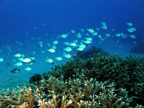
The Kenting photographs show a branching Acropora thicket at the edge of a silt-sand plain, a densely covered but turbid slope of stacked plating colonies and a large brain coral, and a steep plating wall hung with feather stars. Murky water is a recurring complaint in the logs. The offshore islands read very differently in them. At Green Island, four shallow dives in August 2008 logged visibility of more than 45 m ('150 ft-plus'), soft coral meadows, and '1,000 year old Porites colonies.' The Lanyu dives in July and September 2008 logged a 20 m ledge of high coral diversity with sea snakes at Yeyou, a fish-filled cavern and tunnel system at Blue Hole, coral caverns and 50 m visibility at Hen's Rock, a sea snake that followed the divers for 15 minutes at Lion's Head Rock, and abundant hard coral south of Twin Lion Rocks. The three Hsiao Liouchiou dives were fieldwork, checking an artificial reef and swapping settlement tiles, in water murky from run-off but over surprisingly nice coral.
These are unquantified diver impressions. Reef Check surveys around Lanyu recorded 6.3-67% hard coral cover between 1998 and 2019. Reef Check surveys at Houbihu, 1.5 km from the Kenting marker, averaged 18% hard coral in 2024 and 22% in 2025.
Highlights
- Kenting/Nanwan hosts more than fifty logged dives (2008-2011) behind the SHVTS Seriatopora hystrix upwelling work.
- Anderson's Lanyu logs record sea snakes, coral caverns, and 50 m visibility.
- Anderson's Green Island log records soft coral meadows and very old Porites colonies.
- No coral cover has been measured at any site in this unit; nearby Reef Check values range from 6.3% to 67%.
本文為英文摘要的機器翻譯;內容以英文原文為準。 AI translation of this summary; the English is authoritative.
Regional setting
雖然台灣位於主要珊瑚礁帶以北,Spalding et al. (2001) 指出,台灣仍有發育良好的珊瑚群聚,主要分布在南部海岸和離島周圍。黑潮沿著南部和東部海岸帶來溫暖的海水,但其影響在冬季東北季風期間減弱,全島已記錄約300種石珊瑚和1,200種魚類。本島最知名的珊瑚礁是恆春半島和墾丁國家公園(1982年成立)的裙礁群聚。沙溝將它們分隔成不連續的鏈狀,各地動物相差異明顯,有些區域以軟珊瑚(alcyonarians)為主;當地已記錄約250種、分屬58屬的石珊瑚,以及39種、分屬11屬的軟珊瑚。位於南海北部的小琉球擁有多樣的裙礁,而東岸外海的火山島蘭嶼和綠島位於黑潮流經之處,擁有多樣的珊瑚礁群聚。地圖集估計台灣全境約有940 km²的珊瑚礁,並非僅指這些海岸。1999年和2000年的調查顯示,在1998年大範圍白化中約有20%的珊瑚群體死亡。作者列出漁業、海岸開發和觀光為主要壓力,並指出數座核能電廠靠近珊瑚礁,以及蘭嶼的核廢料貯存場。
Wilkinson (2006) 在總結2004年東亞和北亞的珊瑚礁狀況報告時發現,人類活動仍是主要威脅,並因珊瑚白化和近年數個強烈颱風而更加嚴重,大多數地區有大量沉積物逕流、快速的海岸開發,以及極高的漁業壓力;靠近密集人類活動的珊瑚礁持續衰退,而偏遠的珊瑚礁則從1998年的損失中恢復。Souter et al. (2021) 沒有單獨報告台灣的趨勢。他們發現整個東亞海域的石珊瑚覆蓋率從1999年的33%上升到2009年的41%,在2010年大規模白化後於2012年降至35%,並在2016年事件後於2017年滑落至33.9%,十年間相對損失約11%。他們也將台灣列入2020年遭受嚴重白化的地區之一。
Overview
這一組的八個站點涵蓋台灣南端的墾丁/南灣海岸、西南外海的小琉球,以及東南外海的綠島和蘭嶼的五個站點。這裡的紀錄主要來自 Anderson 本人2008-2011年的潛水日誌,而非調查;這些站點都沒有測量珊瑚覆蓋率。各站紀錄的最大深度從綠島的13.7 m 到蘭嶼椰油的35.1 m,有日期的離島潛水介於2008年7月12日至9月21日之間。墾丁/南灣是一個區域標記,涵蓋五十多次紀錄的潛水,深度從3.7 m 到33.5 m。這些潛水支持他的 SHVTS 研究,比較冷水湧升的後壁湖與無湧升的後灣的細枝鹿角珊瑚(Seriatopora hystrix),包括採集 Seriatopora、Pocillopora damicornis 和 Stylophora pistillata、一次珊瑚產卵夜潛、在約30°C 的發電廠溫排水口的潛水,以及一次在排污口附近、珊瑚被藻類覆蓋的潛水。
墾丁的照片顯示粉砂沙地邊緣的一叢枝狀軸孔珊瑚(Acropora)、一片覆蓋茂密但水質混濁、由層疊板狀群體和一個大型腦珊瑚組成的斜坡,以及一面掛滿海百合的陡峭板狀珊瑚壁。日誌中經常抱怨水質混濁。離島在日誌中的描述則截然不同。在綠島,2008年八月的四次淺潛記錄了超過45 m(「150 ft-plus」)的能見度、軟珊瑚草原,以及「1,000 year old Porites colonies」。2008年七月和九月的蘭嶼潛水記錄了椰油一處珊瑚多樣性很高、有海蛇的20 m 礁台,藍洞一個魚群密集的洞穴與隧道系統,雞母岩的珊瑚洞穴和50 m 能見度,獅頭岩一條跟隨潛水員15分鐘的海蛇,以及雙獅岩南側豐富的石珊瑚。小琉球的三次潛水是野外工作——檢查一座人工魚礁並更換附著板——海水因地表逕流而混濁,但珊瑚出乎意料地漂亮。
這些都是未經量化的潛水員印象。蘭嶼周邊的 Reef Check 調查在1998年至2019年間記錄到6.3-67%的石珊瑚覆蓋率。距墾丁標記1.5 km的後壁湖 Reef Check 調查,2024年石珊瑚平均覆蓋率為18%,2025年為22%。
Highlights
- 墾丁/南灣有五十多次紀錄的潛水(2008-2011),支持 SHVTS 細枝鹿角珊瑚(Seriatopora hystrix)湧升研究。
- Anderson 的蘭嶼日誌記錄了海蛇、珊瑚洞穴和50 m 的能見度。
- 他的綠島日誌記錄了軟珊瑚草原和非常古老的 Porites 群體。
- 本單元所有站點都沒有測量珊瑚覆蓋率;附近 Reef Check 的數值介於6.3%至67%之間。
Notable observations
- Taiwan - Kenting / Nanwan (mainland): Log entries record coral overgrown by algae beside a sewage outfall, dives in a power-plant thermal outlet (~30°C), and 2009 typhoon destruction of branching acroporids; one of Anderson's frames, recorded as bleaching, shows partial bleaching of a large massive coral (photo not shown); no disease or predation resolvable in the photographs

Coral cover over time (pooled)
Sites in this region
- Taiwan - Green Island (Ludao, offshore) — 38% (nearest station surveyed in the last 10 years, not this site: Reef Check, Chenshiang station, 2019-04-11, 1.70 km away)
- Taiwan - Hsiao Liouchiou Island (north shore) — 19% (nearest station surveyed in the last 10 years, not this site: Reef Check, Beauty Cave station, mean of 2 surveys (5 m and 10 m), 2019-10-30, 0.97 km away)
- Taiwan - Kenting / Nanwan (mainland) — 15% (nearest survey station, not this site: XL Catlin Seaview Survey, transect 42011 station, 2018-05-03, 0.71 km away)
- Taiwan - Lanyu (Orchid Island): Blue Hole (Yeyou large boat harbor) — 48% (nearest station surveyed in the last 10 years, not this site: Reef Check, Beauty Rock station, mean of 2 surveys (5 m and 10 m), 2019-06-30, 1.94 km away; the station's published position is on land)
- Taiwan - Lanyu (Orchid Island): Hen's Rock (north shore) — 57% (survey at this site: Reef Check, Hen Rock station, mean of 2 surveys (5 m and 10 m), 2019-06-30, 0.00 km away)
- Taiwan - Lanyu (Orchid Island): Lion's Head Rock — 44% (nearest station surveyed in the last 10 years, not this site: Reef Check, Nipple Mountain station, mean of 2 surveys (5 m and 10 m), 2017-06-10, 1.96 km away)
- Taiwan - Lanyu (Orchid Island): South of Twin Lion Rocks — 43% (survey at this site: Reef Check, Lion Couple Rock South station, mean of 2 surveys (5 m and 10 m), 2019-06-30, 0.00 km away)
- Taiwan - Lanyu (Orchid Island): Yeyou
Nearby external survey stations
245 independent survey records within 5 km of a site in this region (each record counted once; 139 lines, and a line that pools several records says how many).
Show all 245 records
- Meng et al. (Kenting monitoring, unpublished) — Nuclear power plant outlet, left (出水口左) (2003): 10% hard coral cover, mean of 3 transects, 2.28 km from Taiwan - Kenting / Nanwan (mainland)
- Meng et al. (Kenting monitoring, unpublished) — Nuclear power plant outlet, left (出水口左) (2004): 9.6% hard coral cover, mean of 3 transects, 2.28 km from Taiwan - Kenting / Nanwan (mainland)
- Meng et al. (Kenting monitoring, unpublished) — Nuclear power plant outlet, left (出水口左) (2005): 12% hard coral cover, mean of 3 transects, 2.28 km from Taiwan - Kenting / Nanwan (mainland)
- Meng et al. (Kenting monitoring, unpublished) — Nuclear power plant outlet, left (出水口左) (2006): 6.6% hard coral cover, mean of 3 transects, 2.28 km from Taiwan - Kenting / Nanwan (mainland)
- Meng et al. (Kenting monitoring, unpublished) — Nuclear power plant outlet, right (出水口右) (2003): 8.7% hard coral cover, mean of 3 transects, 2.28 km from Taiwan - Kenting / Nanwan (mainland)
- Meng et al. (Kenting monitoring, unpublished) — Nuclear power plant outlet, right (出水口右) (2004): 12% hard coral cover, mean of 3 transects, 2.28 km from Taiwan - Kenting / Nanwan (mainland)
- Meng et al. (Kenting monitoring, unpublished) — Nuclear power plant outlet, right (出水口右) (2005): 9.2% hard coral cover, mean of 3 transects, 2.28 km from Taiwan - Kenting / Nanwan (mainland)
- Meng et al. (Kenting monitoring, unpublished) — Nuclear power plant outlet, right (出水口右) (2006): 7.2% hard coral cover, mean of 3 transects, 2.28 km from Taiwan - Kenting / Nanwan (mainland)
- Meng et al. (Kenting monitoring, unpublished) — Tiaoshi (跳石) (2003): 29% hard coral cover, mean of 3 transects, 2.34 km from Taiwan - Kenting / Nanwan (mainland)
- Meng et al. (Kenting monitoring, unpublished) — Tiaoshi (跳石) (2004): 32% hard coral cover, mean of 3 transects, 2.34 km from Taiwan - Kenting / Nanwan (mainland)
- Meng et al. (Kenting monitoring, unpublished) — Tiaoshi (跳石) (2005): 38% hard coral cover, mean of 3 transects, 2.34 km from Taiwan - Kenting / Nanwan (mainland)
- Meng et al. (Kenting monitoring, unpublished) — Tiaoshi (跳石) (2006): 31% hard coral cover, mean of 3 transects, 2.34 km from Taiwan - Kenting / Nanwan (mainland)
- Reef Check — Beauty Cave (2009): 10% hard coral cover, mean of 2 surveys (5 m and 10 m), 0.35 km from Taiwan - Hsiao Liouchiou Island (north shore) (2 records)
- Reef Check — Beauty Cave (2010): 9.4% hard coral cover, mean of 2 surveys (5 m and 10 m), 1.02 km from Taiwan - Hsiao Liouchiou Island (north shore) (2 records)
- Reef Check — Beauty Cave (2014): 25% hard coral cover, mean of 2 surveys (5 m and 10 m), 0.97 km from Taiwan - Hsiao Liouchiou Island (north shore) (2 records)
- Reef Check — Beauty Cave (2015): 32% hard coral cover, mean of 2 surveys (5 m and 10 m), 0.97 km from Taiwan - Hsiao Liouchiou Island (north shore) (2 records)
- Reef Check — Beauty Cave (2016): 23% hard coral cover, mean of 2 surveys (5 m and 10 m), 1.25 km from Taiwan - Hsiao Liouchiou Island (north shore) (2 records)
- Reef Check — Beauty Cave (2017): 26% hard coral cover, mean of 2 surveys, 0.97 km from Taiwan - Hsiao Liouchiou Island (north shore) (2 records)
- Reef Check — Beauty Cave (2018): 25% hard coral cover, mean of 2 surveys (5 m and 10 m), 0.97 km from Taiwan - Hsiao Liouchiou Island (north shore) (2 records)
- Reef Check — Beauty Cave (2019): 19% hard coral cover, mean of 2 surveys (5 m and 10 m), 0.97 km from Taiwan - Hsiao Liouchiou Island (north shore) (2 records)
- Reef Check — Beauty Rock (2016): 67% hard coral cover, mean of 2 surveys (5 m and 10 m), 3.31 km from Taiwan - Lanyu (Orchid Island): Blue Hole (Yeyou large boat harbor) (2 records)
- Reef Check — Beauty Rock (2017): 50% hard coral cover, mean of 2 surveys, 1.94 km from Taiwan - Lanyu (Orchid Island): Blue Hole (Yeyou large boat harbor) (2 records)
- Reef Check — Beauty Rock (2018): 49% hard coral cover, mean of 2 surveys (5 m and 10 m), 1.94 km from Taiwan - Lanyu (Orchid Island): Blue Hole (Yeyou large boat harbor) (2 records)
- Reef Check — Beauty Rock (2019): 48% hard coral cover, mean of 2 surveys (5 m and 10 m), 1.94 km from Taiwan - Lanyu (Orchid Island): Blue Hole (Yeyou large boat harbor) (2 records)
- Reef Check — Chaikou (2008): 34% hard coral cover, mean of 2 surveys (5 m and 9 m), 2.24 km from Taiwan - Green Island (Ludao, offshore) (2 records)
- Reef Check — Chaikou (2009): 50% hard coral cover, mean of 2 surveys (5 m and 10 m), 2.24 km from Taiwan - Green Island (Ludao, offshore) (2 records)
- Reef Check — Chaikou (2010): 38% hard coral cover, mean of 2 surveys (5 m and 10 m), 2.48 km from Taiwan - Green Island (Ludao, offshore) (2 records)
- Reef Check — Chaikou (2014): 51% hard coral cover, mean of 2 surveys (5 m and 10 m), 2.29 km from Taiwan - Green Island (Ludao, offshore) (2 records)
- Reef Check — Chaikou (2015): 49% hard coral cover, mean of 2 surveys (5 m and 10 m), 2.13 km from Taiwan - Green Island (Ludao, offshore) (2 records)
- Reef Check — Chaikou (2016): 46% hard coral cover, mean of 2 surveys (5 m and 10 m), 2.29 km from Taiwan - Green Island (Ludao, offshore) (2 records)
- Reef Check — Chaikou (2017): 58% hard coral cover, mean of 2 surveys (5 m and 10 m), 2.13 km from Taiwan - Green Island (Ludao, offshore) (2 records)
- Reef Check — Chaikou (2018): 60% hard coral cover, mean of 2 surveys (5 m and 10 m), 2.29 km from Taiwan - Green Island (Ludao, offshore) (2 records)
- Reef Check — Chenshiang (2019): 38% hard coral cover, 1.70 km from Taiwan - Green Island (Ludao, offshore)
- Reef Check — Dabaisha (2016): 52% hard coral cover, mean of 2 surveys (5 m and 10 m), 2.50 km from Taiwan - Green Island (Ludao, offshore) (2 records)
- Reef Check — Dabaisha (2018): 24% hard coral cover, mean of 2 surveys (5 m and 10 m), 2.50 km from Taiwan - Green Island (Ludao, offshore) (2 records)
- Reef Check — Dabaisha (2019): 24% hard coral cover, mean of 2 surveys (5 m and 10 m), 2.50 km from Taiwan - Green Island (Ludao, offshore) (2 records)
- Reef Check — Gateway Rock (2008): 32% hard coral cover, mean of 2 surveys (4.5 m and 10 m), 2.56 km from Taiwan - Green Island (Ludao, offshore) (2 records)
- Reef Check — Geban Bay (2009): 10% hard coral cover, mean of 2 surveys (5 m and 14 m), 2.56 km from Taiwan - Hsiao Liouchiou Island (north shore) (2 records)
- Reef Check — Geban Bay (2010): 6.9% hard coral cover, mean of 2 surveys (5 m and 10 m), 3.11 km from Taiwan - Hsiao Liouchiou Island (north shore) (2 records)
- Reef Check — GeeChang (1998): 6.3% hard coral cover, mean of 2 surveys (3 m and 10 m), 3.71 km from Taiwan - Lanyu (Orchid Island): Yeyou (2 records)
- Reef Check — General Rock (2010): 41% hard coral cover, mean of 2 surveys (5 m and 10 m), 2.09 km from Taiwan - Green Island (Ludao, offshore) (2 records)
- Reef Check — General Rock (2017): 40% hard coral cover, mean of 2 surveys (5 m and 10 m), 2.09 km from Taiwan - Green Island (Ludao, offshore) (2 records)
- Reef Check — Gong-guan (2010): 39% hard coral cover, mean of 2 surveys (5 m and 10 m), 1.97 km from Taiwan - Green Island (Ludao, offshore) (2 records)
- Reef Check — Gongguanbi (2017): 40% hard coral cover, mean of 2 surveys (5 m and 10 m), 2.20 km from Taiwan - Green Island (Ludao, offshore) (2 records)
- Reef Check — Haishen Flats (2008): 37% hard coral cover, mean of 2 surveys (4 m and 11 m), 2.18 km from Taiwan - Green Island (Ludao, offshore) (2 records)
- Reef Check — Hejie (2016): 43% hard coral cover, mean of 2 surveys, 3.98 km from Taiwan - Kenting / Nanwan (mainland) (2 records)
- Reef Check — Hejie (2017): 45% hard coral cover, mean of 4 surveys, 3.98 km from Taiwan - Kenting / Nanwan (mainland) (4 records)
- Reef Check — Hejie (2018): 43% hard coral cover, mean of 4 surveys, 3.98 km from Taiwan - Kenting / Nanwan (mainland) (4 records)
- Reef Check — Hejie (2019): 49% hard coral cover, mean of 4 surveys, 3.98 km from Taiwan - Kenting / Nanwan (mainland) (4 records)
- Reef Check — Hejie (2024): 31% hard coral cover, mean of 4 surveys, 3.98 km from Taiwan - Kenting / Nanwan (mainland) (4 records)
- Reef Check — Hejie (2025): 26% hard coral cover, mean of 4 surveys, 3.98 km from Taiwan - Kenting / Nanwan (mainland) (4 records)
- Reef Check — Hen Rock (2015): 62% hard coral cover, mean of 2 surveys (5 m and 10 m), 0.48 km from Taiwan - Lanyu (Orchid Island): Hen's Rock (north shore) (2 records)
- Reef Check — Hen Rock (2017): 50% hard coral cover, mean of 2 surveys (5 m and 10 m), 0.00 km from Taiwan - Lanyu (Orchid Island): Hen's Rock (north shore) (2 records)
- Reef Check — Hen Rock (2018): 63% hard coral cover, mean of 2 surveys (5 m and 10 m), 0.00 km from Taiwan - Lanyu (Orchid Island): Hen's Rock (north shore) (2 records)
- Reef Check — Hen Rock (2019): 57% hard coral cover, mean of 2 surveys (5 m and 10 m), 0.00 km from Taiwan - Lanyu (Orchid Island): Hen's Rock (north shore) (2 records)
- Reef Check — Hongtoe (1998): 8.8% hard coral cover, 2.26 km from Taiwan - Lanyu (Orchid Island): Blue Hole (Yeyou large boat harbor)
- Reef Check — Houbihu (2024): 18% hard coral cover, mean of 4 surveys, 1.52 km from Taiwan - Kenting / Nanwan (mainland) (4 records)
- Reef Check — Houbihu (2025): 22% hard coral cover, mean of 4 surveys, 1.52 km from Taiwan - Kenting / Nanwan (mainland) (4 records)
- Reef Check — Houshi (2010): 38% hard coral cover, mean of 2 surveys (5 m and 10 m), 3.97 km from Taiwan - Hsiao Liouchiou Island (north shore) (2 records)
- Reef Check — Houshi (2016): 7.2% hard coral cover, mean of 2 surveys (5 m and 10 m), 3.97 km from Taiwan - Hsiao Liouchiou Island (north shore) (2 records)
- Reef Check — Houshi (2018): 8.4% hard coral cover, mean of 2 surveys (5 m and 10 m), 3.97 km from Taiwan - Hsiao Liouchiou Island (north shore) (2 records)
- Reef Check — Houshi (2019): 6.6% hard coral cover, mean of 2 surveys (5 m and 10 m), 3.97 km from Taiwan - Hsiao Liouchiou Island (north shore) (2 records)
- Reef Check — Houshi Fringing Reef (2009): 27% hard coral cover, mean of 2 surveys (5 m and 10 m), 3.56 km from Taiwan - Hsiao Liouchiou Island (north shore) (2 records)
- Reef Check — Houshi Fringing Reef (2014): 42% hard coral cover, mean of 2 surveys (5 m and 10 m), 3.69 km from Taiwan - Hsiao Liouchiou Island (north shore) (2 records)
- Reef Check — Houshi Fringing Reef (2015): 51% hard coral cover, mean of 2 surveys (5 m and 10 m), 3.69 km from Taiwan - Hsiao Liouchiou Island (north shore) (2 records)
- Reef Check — Houshi Fringing Reef (2017): 13% hard coral cover, mean of 2 surveys (5 m and 10 m), 3.69 km from Taiwan - Hsiao Liouchiou Island (north shore) (2 records)
- Reef Check — Hutoupo (2014): 50% hard coral cover, mean of 2 surveys (5 m and 10 m), 1.58 km from Taiwan - Lanyu (Orchid Island): Yeyou (2 records)
- Reef Check — Jiangjunyan (2014): 56% hard coral cover, mean of 2 surveys (5 m and 10 m), 2.14 km from Taiwan - Green Island (Ludao, offshore) (2 records)
- Reef Check — Kungkuan (2009): 36% hard coral cover, mean of 2 surveys (5 m and 10 m), 1.99 km from Taiwan - Green Island (Ludao, offshore) (2 records)
- Reef Check — Land Temple/Earth God Temple (2016): 20% hard coral cover, mean of 2 surveys (5 m and 10 m), 1.78 km from Taiwan - Lanyu (Orchid Island): Blue Hole (Yeyou large boat harbor) (2 records)
- Reef Check — Langdao Harbor (2015): 46% hard coral cover, mean of 2 surveys (5 m and 10 m), 2.45 km from Taiwan - Lanyu (Orchid Island): Hen's Rock (north shore) (2 records)
- Reef Check — Lion Couple Rock (2010): 43% hard coral cover, mean of 2 surveys (3 m and 11 m), 0.18 km from Taiwan - Lanyu (Orchid Island): South of Twin Lion Rocks (2 records)
- Reef Check — Lion Couple Rock South (2018): 51% hard coral cover, mean of 2 surveys (5 m and 10 m), 0.00 km from Taiwan - Lanyu (Orchid Island): South of Twin Lion Rocks (2 records)
- Reef Check — Lion Couple Rock South (2019): 43% hard coral cover, mean of 2 surveys (5 m and 10 m), 0.00 km from Taiwan - Lanyu (Orchid Island): South of Twin Lion Rocks (2 records)
- Reef Check — Maiden Rock (2015): 57% hard coral cover, mean of 2 surveys (5 m and 10 m), 3.34 km from Taiwan - Lanyu (Orchid Island): Blue Hole (Yeyou large boat harbor) (2 records)
- Reef Check — Nanliao (1997): 22% hard coral cover, mean of 2 surveys (3 m and 10 m), 2.84 km from Taiwan - Green Island (Ludao, offshore) (2 records)
- Reef Check — Nanliao (1998): 7.7% hard coral cover, mean of 3 surveys (1 m, 3 m, and 10 m), 2.84 km from Taiwan - Green Island (Ludao, offshore) (3 records)
- Reef Check — Nipple Mountain (2017): 44% hard coral cover, mean of 2 surveys (5 m and 10 m), 1.96 km from Taiwan - Lanyu (Orchid Island): Lion's Head Rock (2 records)
- Reef Check — Reef Outside Airport (2009): 11% hard coral cover, mean of 2 surveys (3 m and 6 m), 3.71 km from Taiwan - Lanyu (Orchid Island): Lion's Head Rock (2 records)
- Reef Check — Shilang (2014): 18% hard coral cover, mean of 2 surveys (5 m and 10 m), 1.79 km from Taiwan - Green Island (Ludao, offshore) (2 records)
- Reef Check — Shilang (2015): 18% hard coral cover, mean of 2 surveys (5 m and 10 m), 1.95 km from Taiwan - Green Island (Ludao, offshore) (2 records)
- Reef Check — Shilang (2016): 13% hard coral cover, mean of 2 surveys (5 m and 10 m), 2.15 km from Taiwan - Green Island (Ludao, offshore) (2 records)
- Reef Check — Shilang (2018): 19% hard coral cover, mean of 2 surveys (5 m and 10 m), 2.15 km from Taiwan - Green Island (Ludao, offshore) (2 records)
- Reef Check — Shilang (2019): 16% hard coral cover, mean of 2 surveys (5 m and 10 m), 2.15 km from Taiwan - Green Island (Ludao, offshore) (2 records)
- Reef Check — Shuemezen (1997): 47% hard coral cover, mean of 2 surveys (3 m and 10 m), 1.41 km from Taiwan - Green Island (Ludao, offshore) (2 records)
- Reef Check — Tsaikou (1997): 53% hard coral cover, mean of 2 surveys (3 m and 10 m), 2.39 km from Taiwan - Green Island (Ludao, offshore) (2 records)
- Reef Check — Tsaikou (1998): 31% hard coral cover, mean of 3 surveys (1 m, 3 m, and 10 m), 2.39 km from Taiwan - Green Island (Ludao, offshore) (3 records)
- Reef Check — Tudigong Temple (2009): 14% hard coral cover, mean of 2 surveys (3 m and 6 m), 0.67 km from Taiwan - Lanyu (Orchid Island): Blue Hole (Yeyou large boat harbor) (2 records)
- Reef Check — Turtle Bay (2015): 49% hard coral cover, mean of 2 surveys (5 m and 10 m), 2.06 km from Taiwan - Green Island (Ludao, offshore) (2 records)
- Reef Check — Turtle Bay (2019): 33% hard coral cover, mean of 2 surveys (5 m and 10 m), 2.06 km from Taiwan - Green Island (Ludao, offshore) (2 records)
- Reef Check — Virgin Rock (2010): 48% hard coral cover, mean of 2 surveys (3 m and 10 m), 3.01 km from Taiwan - Lanyu (Orchid Island): Hen's Rock (north shore) (2 records)
- Reef Check — Yeyou (2009): 28% hard coral cover, mean of 2 surveys (3 m and 6 m), 0.00 km from Taiwan - Lanyu (Orchid Island): Yeyou (2 records)
- Reef Check — Yeyou (2016): 20% hard coral cover, mean of 2 surveys (5 m and 10 m), 1.86 km from Taiwan - Lanyu (Orchid Island): Yeyou (2 records)
- Reef Check — Yeyou Harbor (2014): 24% hard coral cover, mean of 2 surveys (5 m and 10 m), 0.47 km from Taiwan - Lanyu (Orchid Island): Yeyou (2 records)
- Reef Check — Yie-yin Village (2010): 45% hard coral cover, mean of 2 surveys (3 m and 12 m), 1.86 km from Taiwan - Lanyu (Orchid Island): Lion's Head Rock (2 records)
- Reef Check — Yuchengwei (2014): 19% hard coral cover, mean of 2 surveys (5 m and 10 m), 1.51 km from Taiwan - Hsiao Liouchiou Island (north shore) (2 records)
- Reef Check — Yuchengwei (2015): 12% hard coral cover, mean of 2 surveys (5 m and 10 m), 1.51 km from Taiwan - Hsiao Liouchiou Island (north shore) (2 records)
- Reef Check — Yuchengwei (2016): 7.5% hard coral cover, mean of 2 surveys (5 m and 10 m), 1.17 km from Taiwan - Hsiao Liouchiou Island (north shore) (2 records)
- Reef Check — Yuchengwei (2017): 10% hard coral cover, mean of 2 surveys (5 m and 10 m), 1.17 km from Taiwan - Hsiao Liouchiou Island (north shore) (2 records)
- Reef Check — Yuchengwei (2018): 8.4% hard coral cover, mean of 2 surveys (5 m and 10 m), 1.17 km from Taiwan - Hsiao Liouchiou Island (north shore) (2 records)
- Reef Check — Yuchengwei (2019): 11% hard coral cover, mean of 2 surveys (5 m and 10 m), 1.17 km from Taiwan - Hsiao Liouchiou Island (north shore) (2 records)
- Ribas-Deulofeu et al. (2016) — Chaikou (2011): 41% hard coral cover, 2.45 km from Taiwan - Green Island (Ludao, offshore)
- Ribas-Deulofeu et al. (2016) — Dabaisha (2011): 41% hard coral cover, 2.22 km from Taiwan - Green Island (Ludao, offshore)
- Ribas-Deulofeu et al. (2016) — Dingbaisha (2011): 4.8% hard coral cover, 4.27 km from Taiwan - Kenting / Nanwan (mainland)
- Ribas-Deulofeu et al. (2016) — Gongguan (2011): 45% hard coral cover, 2.22 km from Taiwan - Green Island (Ludao, offshore)
- Ribas-Deulofeu et al. (2016) — Hongchai (2011): 2.3% hard coral cover, 3.81 km from Taiwan - Kenting / Nanwan (mainland)
- Ribas-Deulofeu et al. (2016) — Houbihu (2011): 48% hard coral cover, 1.11 km from Taiwan - Kenting / Nanwan (mainland)
- Ribas-Deulofeu et al. (2016) — Leidashih (2011): 28% hard coral cover, 2.45 km from Taiwan - Kenting / Nanwan (mainland)
- Ribas-Deulofeu et al. (2016) — Outlet (2011): 45% hard coral cover, 2.22 km from Taiwan - Kenting / Nanwan (mainland)
- Ribas-Deulofeu et al. (2016) — Shihlang (2011): 25% hard coral cover, 2.33 km from Taiwan - Green Island (Ludao, offshore)
- Ribas-Deulofeu et al. (2016) — Tanzihwan (2011): 14% hard coral cover, 3.09 km from Taiwan - Kenting / Nanwan (mainland)
- Ribas-Deulofeu et al. (2016) — Tioashih (2011): 10% hard coral cover, 2.34 km from Taiwan - Kenting / Nanwan (mainland)
- Tkachenko and Soong (2010) — Hobihu No-Take area (2007): 27% hard coral cover, 1.11 km from Taiwan - Kenting / Nanwan (mainland) (2 records)
- Tkachenko and Soong (2010) — Outlet (2007): 30% hard coral cover, 3.49 km from Taiwan - Kenting / Nanwan (mainland) (2 records)
- Tkachenko and Soong (2010) — Tiaoshi (2007): 40% hard coral cover, 2.34 km from Taiwan - Kenting / Nanwan (mainland) (2 records)
- XL Catlin Seaview Survey — transect 42003 (2016): 19% hard coral cover, 1.79 km from Taiwan - Green Island (Ludao, offshore)
- XL Catlin Seaview Survey — transect 42003 (2018): 11% hard coral cover, 1.80 km from Taiwan - Green Island (Ludao, offshore)
- XL Catlin Seaview Survey — transect 42004 (2016): 31% hard coral cover, 2.44 km from Taiwan - Green Island (Ludao, offshore)
- XL Catlin Seaview Survey — transect 42004 (2018): 21% hard coral cover, 2.21 km from Taiwan - Green Island (Ludao, offshore)
- XL Catlin Seaview Survey — transect 42006 (2016): 20% hard coral cover, 2.39 km from Taiwan - Green Island (Ludao, offshore)
- XL Catlin Seaview Survey — transect 42006 (2018): 17% hard coral cover, 1.97 km from Taiwan - Green Island (Ludao, offshore)
- XL Catlin Seaview Survey — transect 42007 (2016): 25% hard coral cover, 2.27 km from Taiwan - Green Island (Ludao, offshore)
- XL Catlin Seaview Survey — transect 42008 (2016): 31% hard coral cover, 2.00 km from Taiwan - Green Island (Ludao, offshore)
- XL Catlin Seaview Survey — transect 42008 (2018): 31% hard coral cover, 2.94 km from Taiwan - Green Island (Ludao, offshore)
- XL Catlin Seaview Survey — transect 42009 (2016): 20% hard coral cover, 1.96 km from Taiwan - Green Island (Ludao, offshore)
- XL Catlin Seaview Survey — transect 42009 (2018): 22% hard coral cover, 1.95 km from Taiwan - Green Island (Ludao, offshore)
- XL Catlin Seaview Survey — transect 42010 (2016): 29% hard coral cover, 2.31 km from Taiwan - Green Island (Ludao, offshore)
- XL Catlin Seaview Survey — transect 42011 (2016): 18% hard coral cover, 0.66 km from Taiwan - Kenting / Nanwan (mainland)
- XL Catlin Seaview Survey — transect 42011 (2018): 15% hard coral cover, 0.71 km from Taiwan - Kenting / Nanwan (mainland)
- XL Catlin Seaview Survey — transect 42012 (2016): 5.1% hard coral cover, 1.26 km from Taiwan - Kenting / Nanwan (mainland)
- XL Catlin Seaview Survey — transect 42012 (2018): 9.9% hard coral cover, 1.23 km from Taiwan - Kenting / Nanwan (mainland)
- XL Catlin Seaview Survey — transect 42013 (2016): 13% hard coral cover, 2.10 km from Taiwan - Kenting / Nanwan (mainland)
- XL Catlin Seaview Survey — transect 42013 (2018): 16% hard coral cover, 2.86 km from Taiwan - Kenting / Nanwan (mainland)
- XL Catlin Seaview Survey — transect 42014 (2016): 25% hard coral cover, 4.09 km from Taiwan - Kenting / Nanwan (mainland)
- XL Catlin Seaview Survey — transect 42014 (2018): 21% hard coral cover, 4.12 km from Taiwan - Kenting / Nanwan (mainland)
- XL Catlin Seaview Survey — transect 42015 (2016): 11% hard coral cover, 2.24 km from Taiwan - Kenting / Nanwan (mainland)
- XL Catlin Seaview Survey — transect 42016 (2016): 19% hard coral cover, 2.08 km from Taiwan - Kenting / Nanwan (mainland)
- XL Catlin Seaview Survey — transect 42017 (2016): 14% hard coral cover, 1.89 km from Taiwan - Kenting / Nanwan (mainland)
- XL Catlin Seaview Survey — transect 42017 (2018): 9.6% hard coral cover, 1.93 km from Taiwan - Kenting / Nanwan (mainland)
All images from Coral Reef Diagnostics. Data on this page are from Reef Check Foundation, XL Catlin Seaview Survey (University of Queensland), Meng et al. (Kenting monitoring, unpublished), Ribas-Deulofeu et al. (2016), and Tkachenko and Soong (2010), not Coral Reef Diagnostics; Coral Reef Diagnostics has no coral cover estimate of its own in this region.
 © Coral Reef Diagnostics.
References
- Souter D, et al. (eds) (2021) Status of Coral Reefs of the World: 2020. International Coral Reef Initiative / Global Coral Reef Monitoring Network. [PDF]
- Spalding MD, et al. (2001) World Atlas of Coral Reefs. University of California Press, Berkeley. [PDF]
- Wilkinson C (2006) Status of coral reefs of the world: summary of threats and remedial action. In: Côté IM, Reynolds JD (eds) Coral Reef Conservation. Cambridge University Press, Cambridge. [PDF]
- Ribas-Deulofeu L, Denis V, De Palmas S, Kuo CY, Hsieh HJ, Chen CA (2016). Structure of Benthic Communities along the Taiwan Latitudinal Gradient. PLOS ONE 11:e0160601. PDF
- Tkachenko KS, Soong K (2010). Protection of habitat types: a case study of the effectiveness of a small marine reserve and impacts of different habitats on the diversity and abundance of coral reef fishes. Zoological Studies 49:195-210.