
Part of the regional summaries: Fiji - Totoya, Fiji - Moala Group (Moala / Totoya / Matuku), and Fiji - Lau
More info
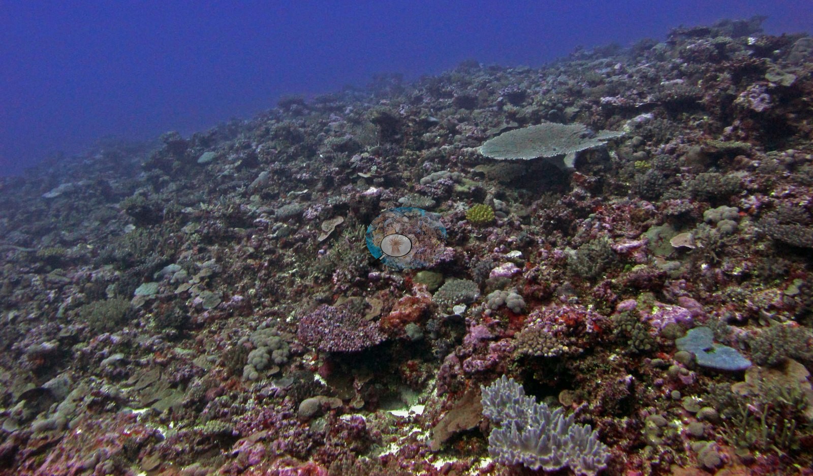
Fiji (NOAA CRW virtual station)A Totoya slope (dived to 25.3 m), known from a single photo, that is continuously covered with table, branching, foliose, and massive corals over pink coralline framework, with no sand or bare rock in view. The survey measured 42% coral cover. Surveyed on the Living Oceans Foundation's Global Reef Expedition.
E dua na baba e Totoya (a nunu kina ki na 25.3 m), e kilai ga mai na dua na itaba, e ubi vakadua ena lase vakatepeli, vakatabataba, vakadrau ni kau (foliose), kei na lase levu vakavatu (massive) ena dela ni ivakatudei ni lumi vakalase (coralline) e roka (pink), ka sega ni laurai e dua na nuku se vatu lala. Na vakadidike e vakatagedegedetaka na ubi ni lase (coral cover) me 42%.
AI translation of this summary; the English is authoritative. (low confidence)
CTD-cast midpoint of 27.2–27.3°C
Eight independent survey stations shown with the program’s logo — click one to see how far it is from this site.
Two other CRD dive sites with their own pages within 5 km shown in orange — click a marker to open its page.
🗺 Detailed map of the Global Reef Expedition dive sites, Totoya, Fiji (Khaled bin Sultan Living Oceans Foundation; opens in a new window)
Site description
Setting
The one habitat photograph looks obliquely up a slope that rises from the lower left toward a broken crest, with open blue water beyond and no sand or bare pavement in view: the bottom is continuously colonized from the foreground to the limit of visibility. The expedition's own site table classifies FJTO07 as a barrier reef on an exposed aspect, surveyed on the fore reef, outside the lagoon.
General benthic features
The framework itself is crusted in pink and mauve coralline algae, and standing on it are a pale tabular Acropora plate part-way up the slope, several smaller tables and corymbose colonies, clusters of stubby digitate and branching colonies, a low blue-gray foliose or plating colony and a pale lavender branching colony in the foreground, scattered small massive and submassive heads, and patches of olive turf and a yellow encrusting growth between them. Relief is broken and decimeter- to meter-scale rather than flat. Alongside the hard coral already reported for this site, the same transects recorded 33% crustose coralline algae, 1.2% turf, 0.6% macroalgae, 3.4% erect algae, and 2.6% cyanobacteria (41% algae in all).
Coral cover
- Reference: Khaled bin Sultan Living Oceans Foundation, Global Reef Expedition (in situ transect)
- Coral cover 42%, from LOF-GRE in situ transects (the mean of all of this station's own transects in the expedition's per-transect benthic data) — a diver transect measurement, not a photographic or computer vision estimate.
- These figures are means of all of this station's own transects in the expedition's per-transect benthic records and are survey results, not photographic estimates.
- Transect mean 42 ± 4.3% SE (n = 5 transects; Living Oceans Foundation per-transect benthic data); the headline above is this all-transect mean.
Stressors
Non-living substrate came to 49% pavement, 3.8% dead coral, 4.6% rubble, and 0.8% sand. The one coral colony from this site with an outlier score was flagged as a physiological outlier (Mayfield et al. 2017, PLoS ONE). Anderson's sampling sheet records one colony sampled here (F14, species not identified) as about 10% bleached. The Living Oceans Foundation transects here recorded 2.6% cyanobacteria and no recently dead coral; they carry no bleaching, disease, or crown-of-thorns field.
Fish and other fauna
No fish are conspicuous in the frame. Paired fish transects recorded about 33 fish species per transect and about 14 kg per 100 m2 of biomass.
Comparisons with other data
WCS Fiji surveyed this site (TY04) in 2011, 0.05 km from the pin (data via MERMAID). Within 5 km, eight WCS Fiji via MERMAID stations recorded station-year means of 36–64% hard coral cover in 2011; the nearest, WCS Fiji via MERMAID at TY04, 0.05 km away, read 58% in 2011.
Other notes
Only one habitat photograph exists for this site, so what follows is a description of that one frame and not a survey of the reef. The frame is strongly blue-violet cast, as a deep ambient-light exposure will be, and that alone rules out reading bleaching, pallor, disease lesions, or predation scars from it; nor can one frame settle the site's zonation, the deeper sand-flat community, or how the assemblage changes across the spur-and-groove structure the surveyors described. Three colonies were tagged and sampled at this site according to Anderson's field records (F13, F14, F15, numbered tags), the third identified as Pocillopora damicornis and flagged in those records as an outlier; the four close-ups (not shown on this page) are tag shots of those colonies and describe the colonies, not the reef.
Survey team's site notes: A diverse benthic community with the dominant scleractinian community differing by location. Shallower areas may be dominated by branching acroporids and (sub)massive poritids with encrusting and plating corals also present. Small mounds of hosting diverse mixed coral assemblages may be present. At greater depths, colonies take on plating morphologies and form a series of shingle-like structures. Prominent macroalgae include Halimeda, Caulerpa, and Dictyota. Large colonies of Diploastrea deep at 30 m. Large Acropora tables and branching Acropora near 20–22 m. High coral cover, with large spur and groove ridges. Sediment filled grooves, with large pieces of rubble. Shallower depths are dominated with small Acropora and Pocillopora colonies. Lobophytum common as well. Fore reef sand flats benthic cover is usually very low because the substrate is mobile and largely unconsolidated thus inhibiting colonization by benthic organisms. In some cases, large Porites lobata colonies and tabular acroporids occur within the sand flats, especially in deeper areas (30-50 m). Macroalgae become more common with depth due to the abatement of wave energy with increasing depth. The deeper fore reef habitats at the base of the reef were generally low relief sand flats, mostly uncolonized. Often there were sparse assemblages of cyanobacteria and small patches of macroalgae, along with isolated larger corals.
Independent surveys nearby
Within 5 km, 8 independent survey stations recorded hard coral cover in 2011. The most recent nearby survey is from 2011, so these values predate recent heat stress. This site's own estimate (42%) sits within the range of these station-year means (36–64%); the methods differ, so the comparison is context, not a like-for-like test.
Collected by other programs using different methods (MERMAID is a data platform: each MERMAID row names the organization that did the survey, and its method is in the row's hover text), so these are context for the figures above, not a like-for-like comparison. Where a station was surveyed more than once, the cell shows either the range of its values or, as a single value, the mean of surveys made in one year. Station names are not dive-site names.
Data & links
- Download benthic survey data (CSV) ↗
- Download all LOF-GRE data (933 sites) ↗
- Photo portfolio ↗
- Coral Reef Diagnostics region page ↗
All images from Coral Reef Diagnostics. Data are from the Khaled bin Sultan Living Oceans Foundation Global Reef Expedition, Coral Reef Diagnostics, and the organizations named in the data sources above.
 © Coral Reef Diagnostics.