
Chagos Archipelago - Three Brothers lagoon (BITB34.5)

Part of the regional summaries: Chagos Archipelago - Great Chagos Bank West / Brothers / Eagle and Chagos Archipelago
More info
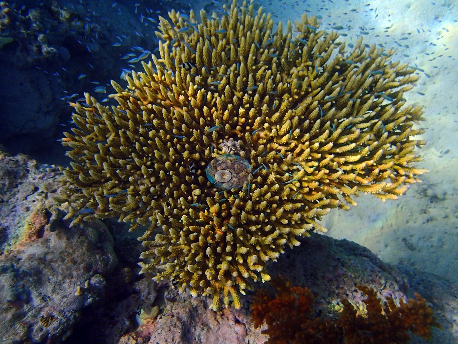
Chagos Archipelago, UK (NOAA CRW virtual station)A small lagoonal patch reef in the Three Brothers group, inside the lagoon near Middle Brother, with no transect of its own. Its photographs show a large golden-olive table coral with healthy pale growing tips, clouds of chromis, and a humbug damselfish. Surveyed on the Living Oceans Foundation's Global Reef Expedition.
(approximate field note, about 30°C)
Two independent survey stations shown with the program’s logo — click one to see how far it is from this site.
Fourteen other CRD dive sites with their own pages within 5 km shown in orange — click a marker to open its page.
🗺 Detailed map of the Global Reef Expedition dive sites, Three Brothers, Chagos (Khaled bin Sultan Living Oceans Foundation; opens in a new window)
Site description
General benthic features
What the three frames show. The first frame carries the site: a large corymbose table, golden-olive with pale cream axial tips, on coralline-crusted pavement above open sand, with dense clouds of small blue-green damselfish and one banded humbug in the branches (e.g., Image 1).
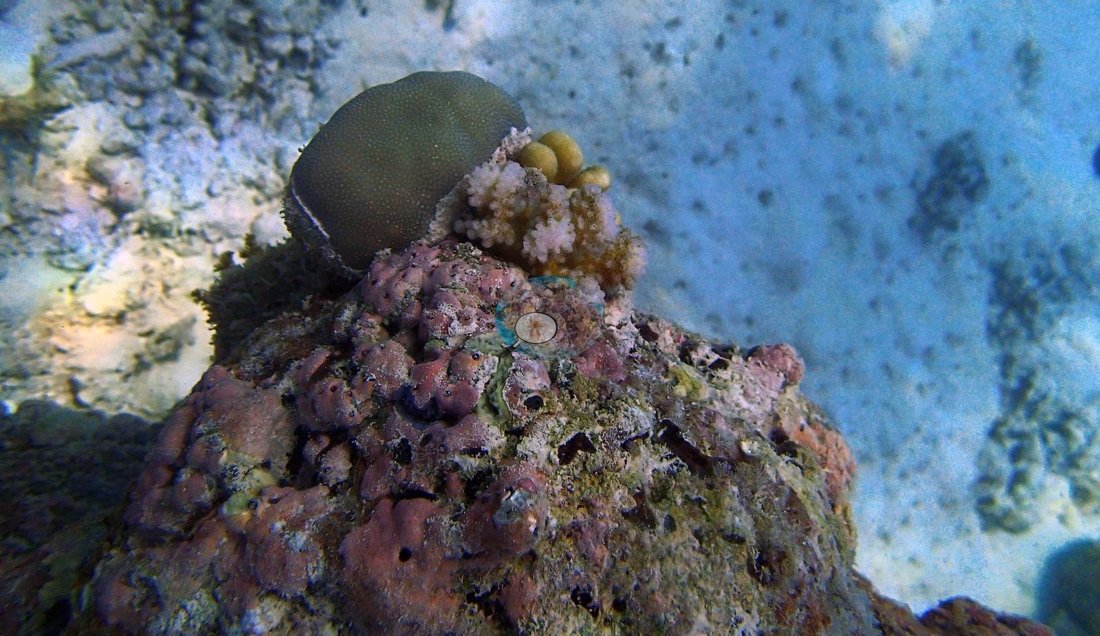
Lower right are dark red-orange fine-branched colonies. The second frame is a coralline-crusted bommie with a smooth dark-olive encrusting plate of fine dense corallites and a pale cream knobby-branched colony compatible with a Pocillopora-type, still holding tan pigment low down (e.g., Image 2).
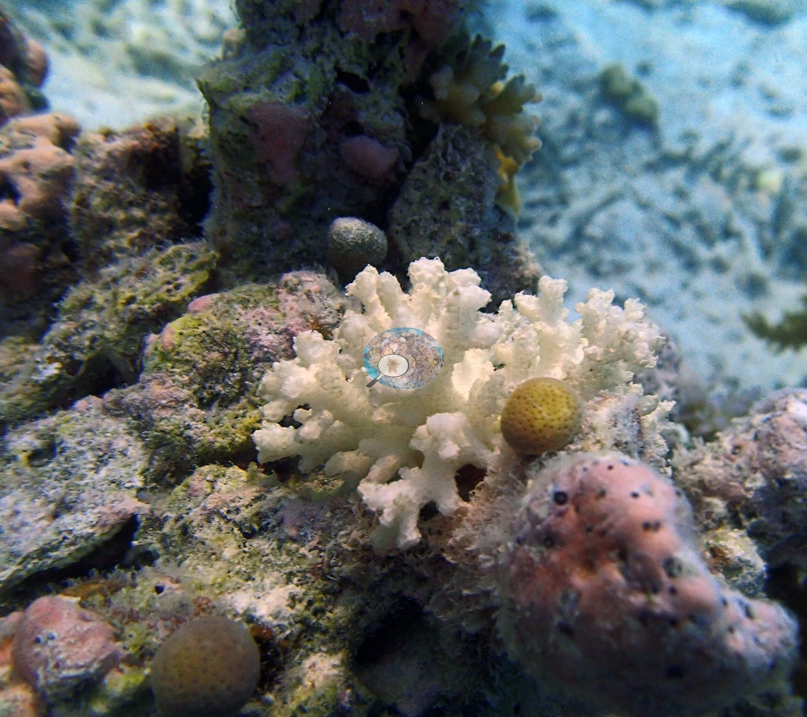
The third frame is dominated by a wholly chalk-white blunt-branched digitate colony, again compatible with a Pocillopora-type, beside a pigmented knob, CCA crust, and heavy turf (e.g., Image 3).
Coral cover
- This is a ".5" site: informal survey images were annotated in CoralNet, but no formal benthic transect was ever run here.
Stressors
Published bleaching for this informal dive is 17% (Mayfield & Dempsey 2026, Oceans, suppl. S1; CoralNet analysis of 3 photographs). The pale tips of the table coral in Image 1 are growth margins. The wholly white branching colony in Image 3 is either bleached or recently dead; the photograph does not settle which. Anderson's field sheet records all nine colonies sampled on this dive as unbleached, one of them more than 30% dead (see Dive record below). No crown-of-thorns starfish (COTS) or other corallivores were evident.
Comparisons with other data
Spalding et al. (2025) surveyed a nearby station (Great Chagos Bank - Middle Brother, lagoon) in 2024, 0.18 km from the pin. Within 5 km, two independent stations recorded station-year means of 21–41% hard coral cover between 2006 and 2015; the nearest of these, XL Catlin Seaview Survey at transect 36004, 1.08 km away, read 21% in 2015.
Dive record
Anderson's afternoon dive on 19 March 2015 entered the water at 15:48 and lasted 60 minutes, to a maximum depth of 10.2 m (the field sheet); the notes describe a murky, calm lagoon dive with low visibility, isolated bommies in the sand at 10 m, and a large bommie rising to about 1 m below the surface, mostly soft corals with some P. acuta; they also note a sickly turtle. Anderson sampled eight Pocillopora acuta colonies (confirmed by RFLP), CHPd26-33, collected 15:56-16:45 at 4.6-9.9 m: all were recorded as healthy or likely healthy and unbleached, with yellow-cream or dark pigmentation, except CHPd32 (5.2 m; more than 30% dead), and dead P. acuta lay near CHPd26. Anderson also sampled one Seriatopora sp., ChSe16 (15:52, 9.8 m; a very strange-looking colony with tiny, brittle branches, possibly S. hystrix, the only one found at the site; unbleached). Pocillopora acuta colonies from this archipelago were analyzed in Thomas et al. (2026, Global Ecology and Biogeography 35:e70305, https://doi.org/10.1111/geb.70305).
Other notes
No transect exists. No benthic transect data are available for BITB34.5, so there is no per-genus breakdown, no algal cover, and no basis for genus richness or diversity indices.
Coral cover score card
This site is listed in a stand-alone coral cover score card.
Independent surveys nearby
| Agency / program | Year(s) | Stations / distance | Link |
|---|---|---|---|
| Sheppard et al. (2008) | 2006 | 1 station, 1.16 km | Records ↓ |
| Spalding et al. (2025) | — | 1 station, 0.18 km | Records ↓ |
| XL Catlin Seaview Survey | 2015 | 1 station, 1.08 km | Records ↓ |
Within 5 km, 2 independent survey stations recorded hard coral cover in 6 records between 2006 and 2015. The most recent nearby survey is from 2015, so these values predate recent heat stress. One further row in the table has no survey date, so it is listed but not part of this summary.
Collected by other programs using different methods (the XL Catlin Seaview Survey uses photo-transects with automated image annotation), so these are context for the figures above, not a like-for-like comparison. Where a station was surveyed more than once, the cell shows either the range of its values or, as a single value, the mean of surveys made in one year. Station names are not dive-site names.
| Agency | Site / location | Date | Hard coral cover (%) | Distance | Link |
|---|---|---|---|---|---|
| Sheppard et al. (2008) | Great Chagos Bank | 2006 | 41% (5 records) | 1.16 km | doi:10.3354/meps07436 |
| XL Catlin Seaview Survey | transect 36004 | 2015 | 21% | 1.08 km | doi:10.14264/uql.2019.930 |
| Spalding et al. (2025) | Great Chagos Bank - Middle Brother, lagoon (E aspect, 1-3 m) | pre-bleaching baseline | 50% | 0.18 km | — |
Data & links
- Download all LOF-GRE data (933 sites) ↗
- CoralNet image repository for this region ↗
- Photo portfolio ↗
- Coral Reef Diagnostics page for this area ↗
All images from Coral Reef Diagnostics. Data are from the Khaled bin Sultan Living Oceans Foundation Global Reef Expedition, Coral Reef Diagnostics, and the organizations named in the data sources above.
© Coral Reef Diagnostics.
References
- Mayfield AB, Dempsey AC (2026). Using tourist diver images to estimate coral cover and bleaching prevalence in a remote Indian Ocean coral reef system. Oceans 7(1):1. PDF
- Sheppard C, Harris A, Sheppard A (2008). Archipelago-wide coral recovery patterns since 1998 in the Chagos Archipelago, central Indian Ocean. Marine Ecology Progress Series 362:109-117. PDF
- Spalding M, Bourasseau M, et al. (2025). Coral bleaching and mortality in the Chagos Archipelago, 2024. British Indian Ocean Territory Administration report (gray literature). PDF
- Gonzalez-Rivero M, et al. (2019). Seaview Survey photo-quadrat and image classification dataset. The University of Queensland (UQ eSpace) data collection. DOI