
Part of the regional summary: USA - Florida

2019-08-21
2019-10-09
2019-12-04
More info
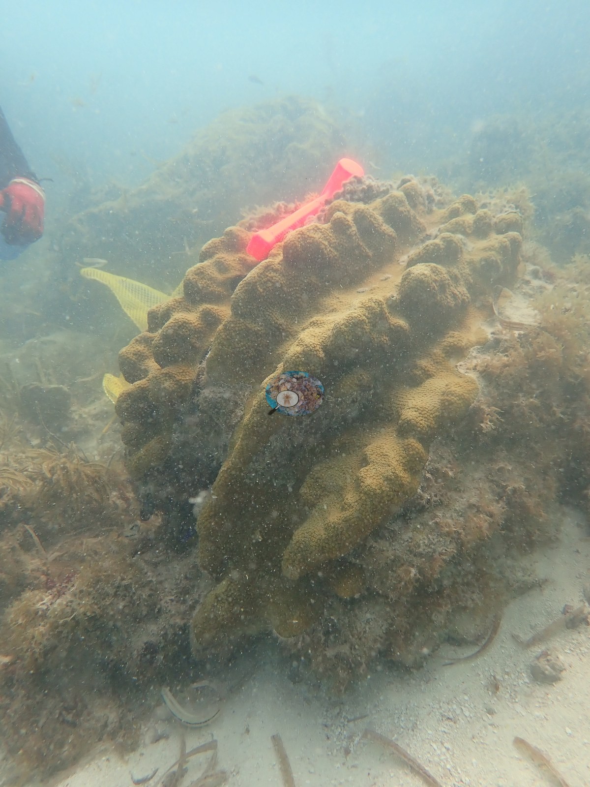
Florida Keys (NOAA CRW virtual station)One of two offshore reefs among Anderson's four NOAA study sites, chosen in 2017 because it still held enough disease-free colonies to sample. It is a low-relief hardground reef where isolated star-coral mounds stand on largely dead pedestals, with partial bleaching in 2019; sea fans and sea plumes make up the rest of its structure.
45 independent survey stations shown with the program’s logo — click one to see how far it is from this site.
One other CRD dive site with its own page within 5 km shown in orange — click a marker to open its page.
1 of the 6 photographs on this page is shown beside the text that discusses them under "Site description" below.
Site description
Setting
Little Conch is an Upper Keys offshore reef and the fourth of Anderson's NOAA/FKNMS research sites, with colonies tagged and genotyped by the NOAA AOML team in July 2017, which Anderson resampled in 2019. It mattered to the study as "the lone offshore site with enough disease-free colonies for coring".
General benthic features
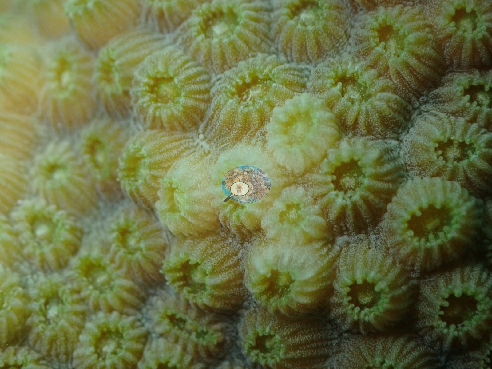
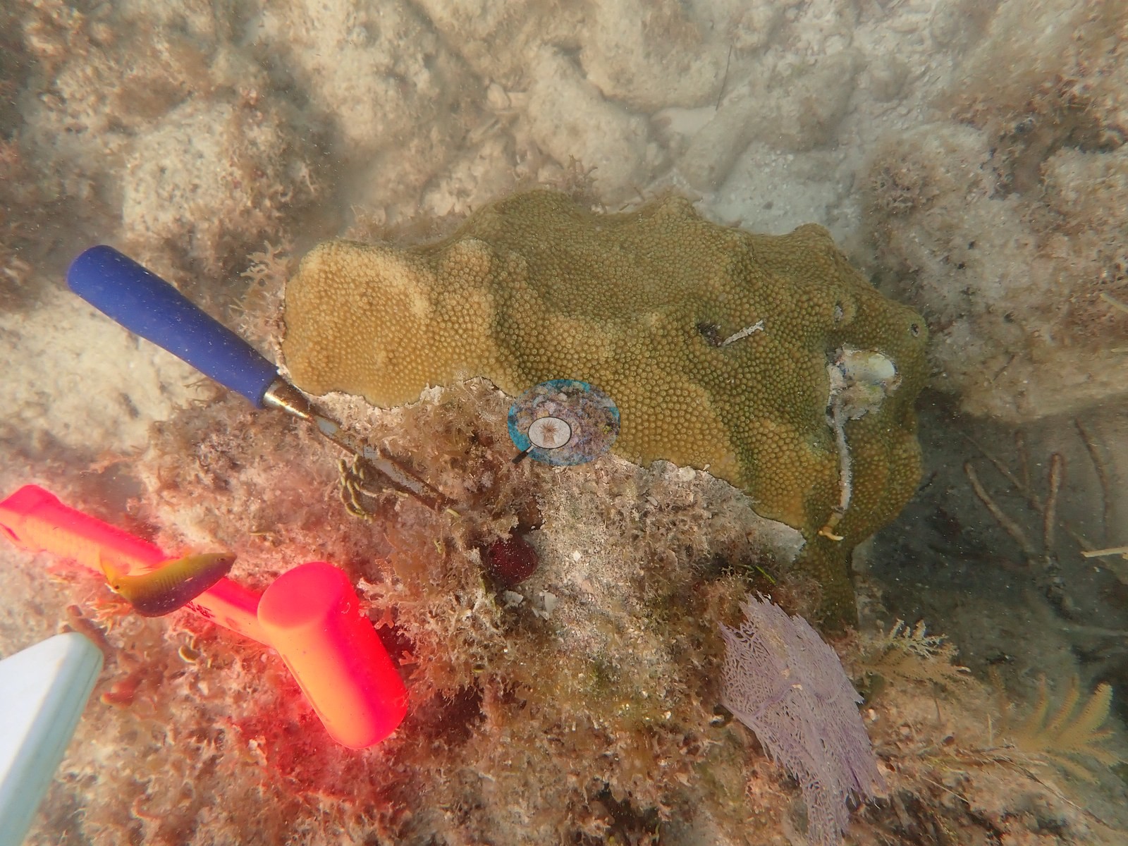
The frames show a reef of isolated Orbicella faveolata mounds standing on largely dead pedestals — a living tan cap on top, the flanks below given over to algal turf, red encrusting sponges, and rubble — set on low hardground with mustard-yellow mounding colonies, sea plumes, sea fans, and open sand between them.
Coral cover
- Coral cover: 6.9% (August 2016), from the NOAA NCRMP and NOAA AOML photo-transect survey of this reef published by Manzello et al. (2019, Global Change Biology) — 40 frames on two 10 m transects, point-counted. The two deeper Upper Keys offshore sites read 1.5–1.6%, and the 3.3% figure in that study is the average of all three, not this reef.
Stressors
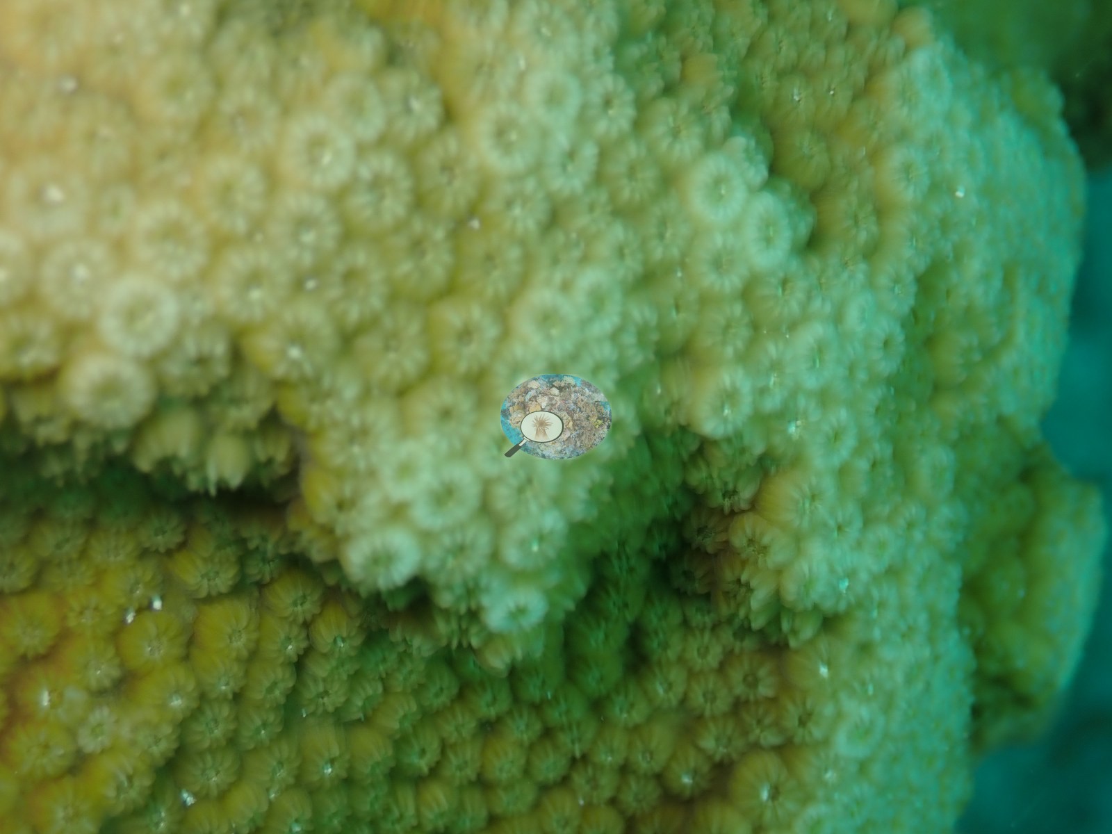
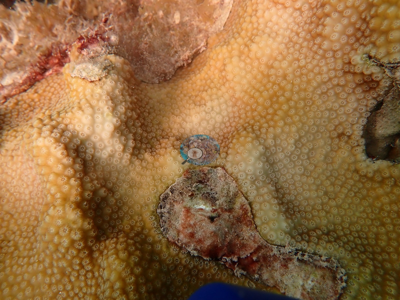
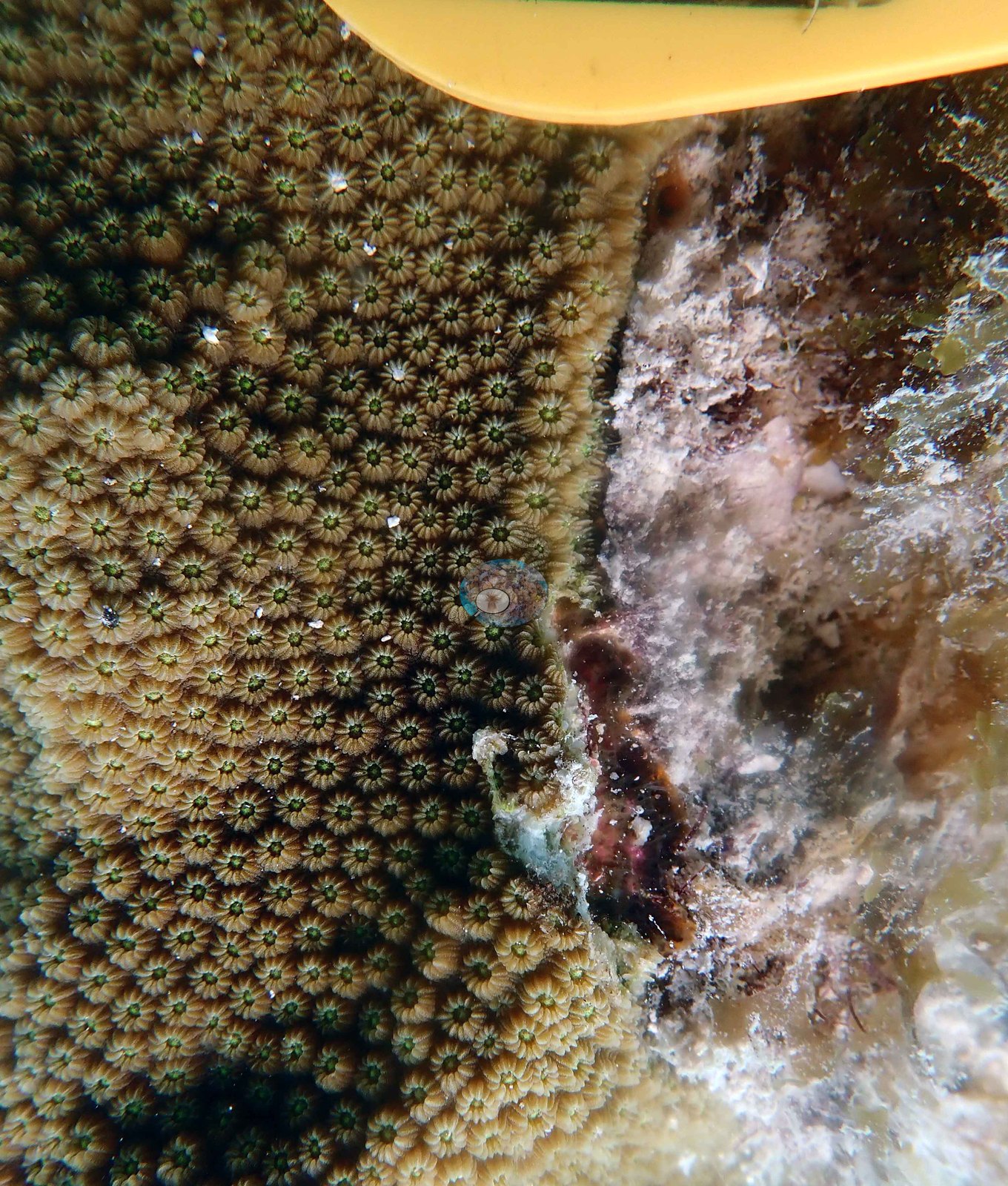
A frame noted as an Orbicella faveolata being smothered shows a clump of red-brown filamentous algae in a fold of a live coral colony, and Anderson's log records the reef "being smothered by macroalgae" (10 July 2019) and "being smothered by algae" (4 December 2019). On 21 August 2019 Anderson logged "some incidence of bleaching", and the sampled colonies that day show sharply bordered pale zones beside green-brown tissue (partial bleaching). A frame noted as a lesion on tagged colony LC-3128 shows a tissue-loss margin with bare skeleton beside brown tissue on a tagged colony (e.g., Image 6).
No corallivores were evident.
Comparisons with other data
Apart from the NOAA survey shown here, we found no other surveys at this site as of 2026. Within 5 km, 45 independent stations recorded station-year means of 0.0–36% hard coral cover between 1996 and 2024; the nearest, NOAA NCRMP at FLK-248, 0.44 km away, read 6.0% in 2015.
Dive record
Anderson logged four dives here in 2019 (10 July, 21 August, 9 October, 4 December; 5.8–6.1 m maximum, long bottom times of 33 to 62 minutes, 25.7–31.0°C (dive averages)).
Other notes
The photographs are working shots, not scenery: nearly every frame has a fluorescent hammer, a mesh collection bag, or a numbered dive slate in it. Several colonies are so heavily and repeatedly cored that Anderson likened one to Swiss cheese.
Coral cover score card
This site is listed in a stand-alone coral cover score card.
Dive history
| Date | Time in | Max depth (m) | Bottom time (min) |
|---|---|---|---|
| 2019-07-10 | 14:04 | 6.1 | 61 |
| 2019-08-21 | 09:22 | 5.8 | 62 |
| 2019-10-09 | 11:25 | 5.8 | 45 |
| 2019-12-04 | 11:13 | 5.8 | 33 |
Independent surveys nearby
| Agency / program | Year(s) | Stations / distance | Link |
|---|---|---|---|
| FWC CREMP (Florida Keys) | 1996–2024 | 4 stations, 4.55–4.66 km | Records ↓ |
| NOAA NCRMP | 2014–2016 | 29 stations, 0.44–4.94 km | Records ↓ |
| NOAA NCRMP Florida | 2024 | 7 stations, 1.57–4.84 km | Records ↓ |
| Reef Check | 1997–1999 | 5 stations, 2.60–4.68 km | Records ↓ |
Within 5 km, 45 independent survey stations recorded hard coral cover in 155 records between 1996 and 2024. Of the 9 stations surveyed in more than one year, 7 declined (by 0.2–26 points) and 2 increased (by 3.1–7.0 points) between their first and latest surveys. Four stations share the longest span (1996–2024); one, Conch Shallow #531 (FWC CREMP (Florida Keys), 4.55 km away), went from 3.9% in 1996 to 0.9% in 2024. Since 2021, station-year means average 1.4% (range 0.0–10%; n = 23 station-years from 23 records). This site's headline survey value (6.9%) sits 3.9 points above the recent range of station-year means up to 2 km away (0.0–3.0%); the methods differ, so the comparison is context, not a like-for-like test.
Collected by other programs using different methods (Reef Check uses point-intercept transects; NOAA rows come from NOAA monitoring programs (NCRMP, PIFSC, NCCOS), and each row's method is in its hover text; FWC-FWRI uses fixed-station point counts), so these are context for the figures above, not a like-for-like comparison. Where a station was surveyed more than once, the cell shows either the range of its values or, as a single value, the mean of surveys made in one year. Station names are not dive-site names.
Show all 155 independent survey records
| Agency | Site / location | Date | Hard coral cover (%) | Distance | Link |
|---|---|---|---|---|---|
| FWC CREMP (Florida Keys) | Conch Shallow #531 | 1996–2024 | 0.2–3.9% (29 surveys) | 4.55 km | — |
| FWC CREMP (Florida Keys) | Conch Shallow #532 | 1996–2024 | 0.4–4.4% (19 surveys) | 4.55 km | — |
| FWC CREMP (Florida Keys) | Conch Shallow #533 | 1996–2024 | 0.0–2.7% (29 surveys) | 4.66 km | — |
| FWC CREMP (Florida Keys) | Conch Shallow #534 | 1996–2024 | 0.1–20% (29 surveys) | 4.66 km | — |
| Reef Check | Davis Reef | 1997–1998 | 2.5–5.6% (range of yearly means; 3 surveys) | 2.60 km | — |
| Reef Check | Conch reef (research only) | 1997 | 8.1% | 4.56 km | — |
| Reef Check | Conch Reef | 1997–1999 | 2.5–6.3% (range of yearly means; 4 surveys) | 4.57 km | — |
| Reef Check | Crocker Control | 1997–1998 | 5.0–5.6% (2 surveys) | 4.68 km | — |
| Reef Check | Pleasure Reef | 1998 | 3.8% | 4.53 km | — |
| NOAA NCRMP | FLK-22 | 2014 | 5.0% | 1.93 km | — |
| NOAA NCRMP | FLK-21 | 2014 | 0.0% | 2.34 km | — |
| NOAA NCRMP | FLK-8 | 2014 | 4.5% | 2.95 km | — |
| NOAA NCRMP | FLK-7 | 2014 | 1.0% | 3.05 km | — |
| NOAA NCRMP | FLK-428 | 2014–2016 | 2.0–9.0% (range of yearly means; 2 records) | 3.05 km | — |
| NOAA NCRMP | FLK-213 | 2014 | 25% | 3.85 km | — |
| NOAA NCRMP | FLK-221 | 2014 | 3.0% | 4.14 km | — |
| NOAA NCRMP | FLK-20 | 2014 | 3.0% | 4.26 km | — |
| NOAA NCRMP | FLK-3 | 2014 | 1.0% | 4.26 km | — |
| NOAA NCRMP | FLK-4 | 2014 | 1.0% | 4.26 km | — |
| NOAA NCRMP | FLK-2 | 2014 | 0.0% | 4.50 km | — |
| NOAA NCRMP | FLK-1 | 2014 | 2.0% | 4.50 km | — |
| NOAA NCRMP | FLK-211 | 2014–2016 | 10–36% (range of yearly means; 2 records) | 4.89 km | — |
| NOAA NCRMP | FLK-212 | 2014 | 14% | 4.89 km | — |
| NOAA NCRMP | FLK-173 | 2014 | 8.0% | 4.93 km | — |
| NOAA NCRMP | FLK-245 | 2014 | 6.0% | 4.94 km | — |
| NOAA NCRMP | FLK-248 | 2015 | 6.0% | 0.44 km | — |
| NOAA NCRMP | FLK-249 | 2015 | 1.0% | 2.34 km | — |
| NOAA NCRMP | FLK-442 | 2016 | 6.0% | 1.41 km | — |
| NOAA NCRMP | FLK-437 | 2016 | 4.0% | 1.41 km | — |
| NOAA NCRMP | FLK-440 | 2016 | 10% | 2.95 km | — |
| NOAA NCRMP | FLK-427 | 2016 | 8.0% | 2.95 km | — |
| NOAA NCRMP | FLK-435 | 2016 | 4.0% | 3.25 km | — |
| NOAA NCRMP | FLK-426 | 2016 | 9.0% | 4.14 km | — |
| NOAA NCRMP | FLK-434 | 2016 | 4.0% | 4.26 km | — |
| NOAA NCRMP | FLK-433 | 2016 | 2.0% | 4.26 km | — |
| NOAA NCRMP | FLK-431 | 2016 | 3.0% | 4.44 km | — |
| NOAA NCRMP | FLK-436 | 2016 | 10% | 4.85 km | — |
| NOAA NCRMP | FLK-430 | 2016 | 1.0% | 4.94 km | — |
| NOAA NCRMP Florida | FLK PSU 1130-1 | 2024 | 0.0% | 1.57 km | NCEI 0306238 |
| NOAA NCRMP Florida | FLK PSU 1128-1 | 2024 | 3.0% | 1.91 km | NCEI 0306238 |
| NOAA NCRMP Florida | FLK PSU 1672-1 | 2024 | 10% | 2.96 km | NCEI 0306238 |
| NOAA NCRMP Florida | FLK PSU 1241-1 | 2024 | 2.0% | 3.72 km | NCEI 0306238 |
| NOAA NCRMP Florida | FLK PSU 1372-1 | 2024 | 0.0% | 4.51 km | NCEI 0306238 |
| NOAA NCRMP Florida | FLK PSU 1006-1 | 2024 | 1.0% | 4.60 km | NCEI 0306238 |
| NOAA NCRMP Florida | FLK PSU 1007-1 | 2024 | 0.0% | 4.84 km | NCEI 0306238 |
Data & links
All images from Coral Reef Diagnostics. Data are from Coral Reef Diagnostics and the organizations named in the data sources above.
© Coral Reef Diagnostics.