
Kenya - Trumpet Area (Watamu)

Part of the regional summary: Kenya
More info
Kenya (NOAA CRW virtual station) · East African Coral Coast ecoregion mean=4.1°C-heating weeksTrumpet Area is a low-relief reef flat off Watamu, named for a dense mid-water aggregation of trumpetfish and cornetfish that drifted over the reef during the survey. Coral sits as scattered colonies rather than continuous framework, and bleaching was severe (85.8% of tissue) across Acropora, massive corals, and even the leathery soft corals that form the flat's largest continuous stands - one frame is captioned 'bleached soft coral' by Anderson himself. Published cover was 21%; turtles and a peacock mantis shrimp were also recorded.
Sakafu ya mwamba yenye mwinuko mdogo nje ya Watamu iliyofanyiwa kazi katika mzamio wa dakika 53, ambapo vishada vikubwa vyenye mikunjo vinasomeka kama matumbawe laini ya ngozi badala ya sahani ngumu za majani. Samaki-tarumbeta, kasa, na kamba-tausi wote wameandikwa; hakuna nyota za bahari zenye miiba wala vidonda vya ugonjwa vinavyoonekana katika picha 205.
Tafsiri ya muhtasari huu kwa AI; Kiingereza ndicho kinachotumika rasmi. Translated from the site’s shorter map summary.
Six independent survey stations shown with the program’s logo — click one to see how far it is from this site.
Three other CRD dive sites within 5 km shown in orange — click a marker to open its page.
Site description
General benthic features
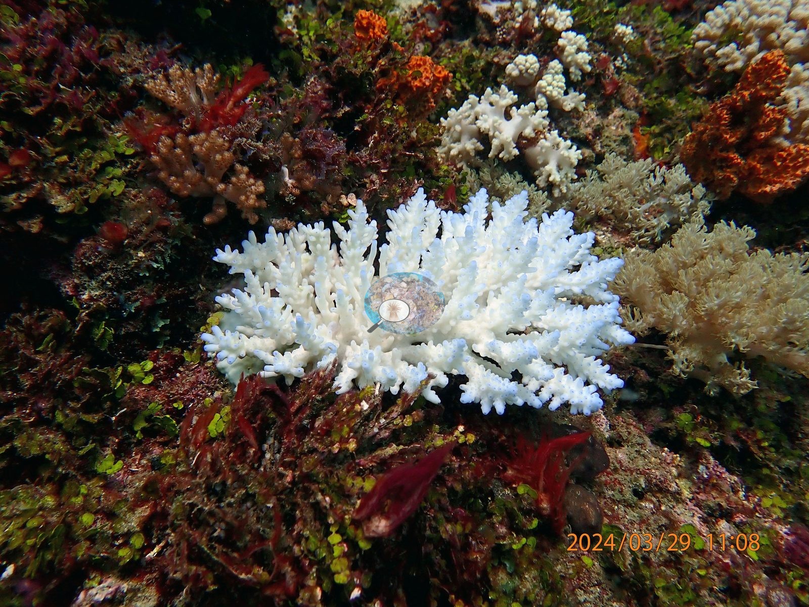
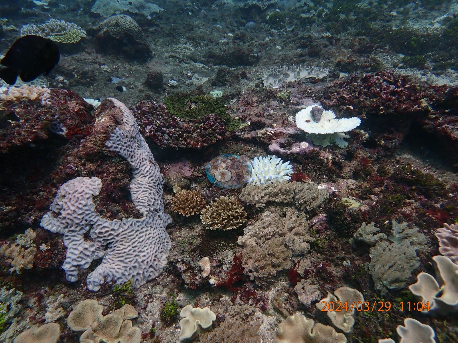
The full 205-frame set confirms a low-relief reef flat rather than a wall or spur-and-groove: a broad algal-and-turf pavement with rubble, shallow sand pockets, and a few small undercut ledges, over which coral sits as discrete colonies rather than continuous framework. Wide shots taken minutes apart along the track look consistent -- there is no zone of dense, healthy coral anywhere in the set. Corymbose and digitate staghorn corals (Acropora) are the most numerous stony corals, occurring as scattered dinner-plate to arm-span colonies, and they carry the visible bleaching load: frame after frame shows them brilliant, uniform bone-white to the branch tips (frames 1, 24, 45, 75, 87, 101, 109, 114, 137, 143, 168, 180) (e.g., Image 2).
Large meandroid massives with worm-track ridges (a Platygyra-type morphology, one over a meter across) are the most conspicuous single heads and sit in an intermediate state -- pale lilac-white with residual host pigment (frames 46, 71, 121, 186) -- while other massives, including a cerioid Favites-type head and several small Goniastrea-type domes, are still solidly pigmented (frames 47, 165) (e.g., Image 1).
The largest continuous stands on the pavement are not stony corals at all but lobed and ruffled leathery soft corals (Sarcophyton/Lobophytum-type), which carpet whole sections of flat in several frames (3, 53, 76, 102, 106, 122-124, 176); these too are affected, ranging from healthy chocolate-brown through washed-out cream to one frame Anderson himself labeled "bleached soft coral" (e.g., Image 3).
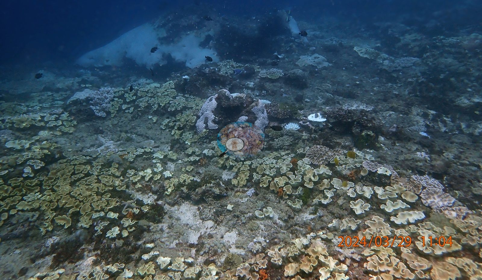
Genuine foliose and plate stony corals are present but subordinate: tiered whorls, flat gray plates, and a large ridged Pachyseris-type sheet, most of them paled to cream (frames 92, 146, 163, 170, 171, 186). Between the corals the pavement is heavily algal: dense turf, maroon and crimson fleshy macroalgae, bright green segmented Halimeda (one frame is filenamed "too much Halimeda"), and pink crustose coralline crusts on rubble, with orange encrusting sponges scattered through.
Coral cover
Hard coral cover 21%, with 85.8% of hard coral tissue bleached -- the published CoralNet values from Mayfield (2025), not recomputed here. Coral cover 21% -- and 85.8% of hard coral tissue bleached (March-April 2024). Measured from 193 white-balanced photographs taken at this site during the 2024 Western Indian Ocean mass bleaching event and point-annotated in CoralNet, published in Mayfield, A.B. (2025) A Citizen Science Approach for Documenting Mass Coral Bleaching in the Western Indian Ocean. Environments 12(8):276. doi:10.3390/environments12080276.
Stressors
A handful of tabular and corymbose Acropora remain fully brown or golden-tan (frames 56, 108, 136, 190), and several colonies are caught mid-transition with white tips over a pigmented base, so the response is colony-specific as well as growth-form-specific. Submassive and encrusting Porites-type mounds appear both fully pigmented and stark chalk-white within the same frame (frames 110, 111). Partial mortality is already visible on the biggest colonies -- bare skeleton furred with turf or bound by algal film across the top of encrusting sheets and one massive head (frames 88, 98, 199). Typical recent thermal stress for the ecoregion is a mean annual maximum of 4.1 degree-heating weeks (2021-2025, NOAA Coral Reef Watch, East African Coral Coast); in 2024 NOAA recorded a Kenyan peak of 13.5 DHW on 18 April, the highest since records began in 1985, and in situ temperatures ran about 1.3 C above NOAA's estimates, so true heat stress was likely nearer 22 DHW. No crown-of-thorns starfish (COTS) or other corallivores evident.
Fish and other fauna
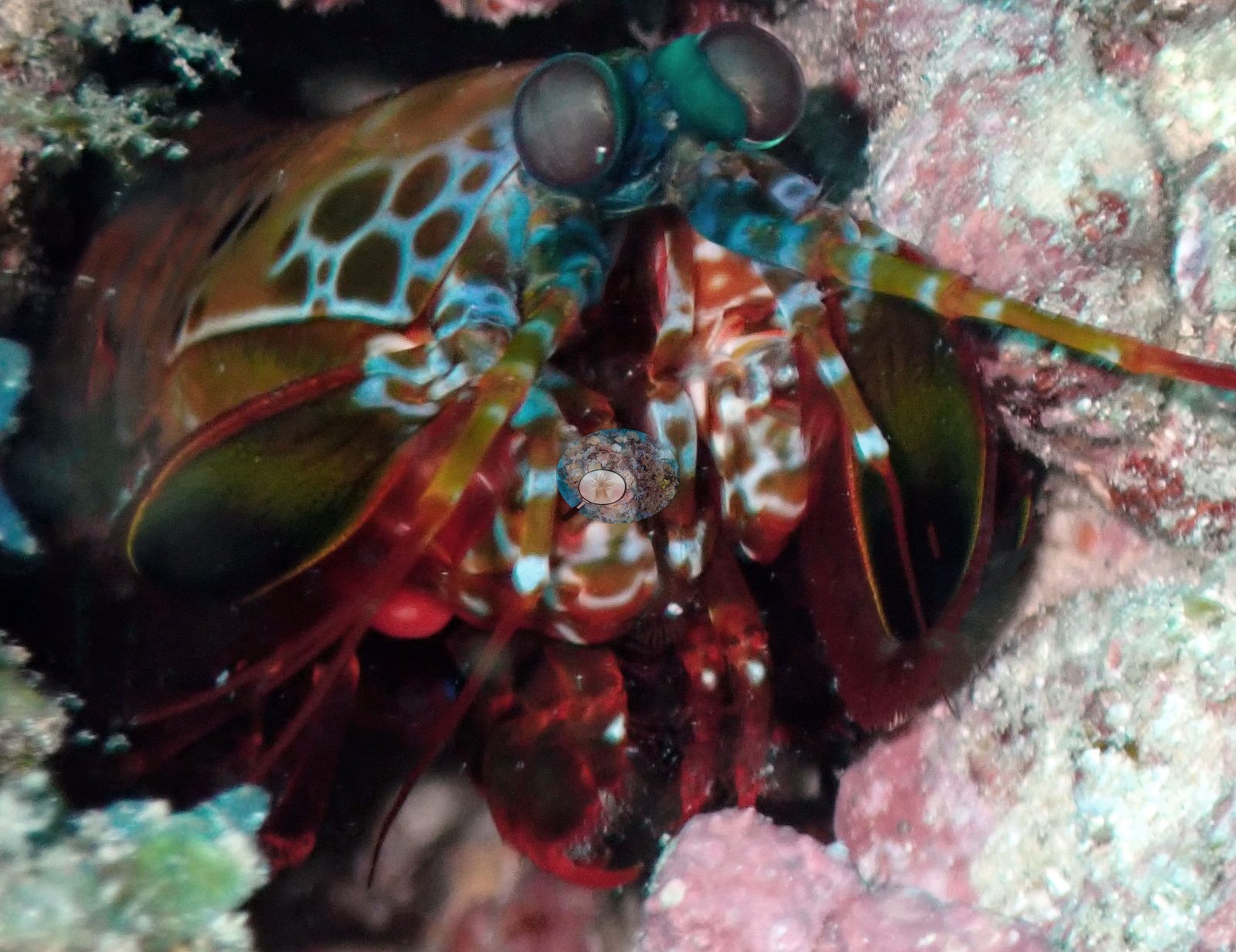
The site is named for the fish: between about 11:29 and 11:30 a dense aggregation of trumpetfish/cornetfish hangs in mid-water and drifts over the flat, and eight consecutive frames are given over to it. Turtles were photographed on at least two separate encounters (11:15-11:19), one resting among leathery soft corals and one grazing the algal pavement. A peacock mantis shrimp (Odontodactylus scyllarus) was shot at close range in coralline-crusted rubble, and a small reticulate yellow-and-dark dorid nudibranch gets three macro frames at 11:40 (e.g., Image 4).
Also present: a blue sea star, a pale lobed fungiid, Moorish idols, bannerfish, powder-blue surgeonfish, a bluestripe snapper, and damselfish and chromis holding position over the coral heads in nearly every wide shot.
Comparisons with other data
No independent survey was made at this exact site; the nearest ones are listed in the table below.
Dive record
Surveyed 29 March 2024, roughly 11:04 to 11:57 at about 10 m off Watamu, during the 2024 Western Indian Ocean mass bleaching event; the topside frame shows the dive boat Mrembo on a flat, sunlit sea. Surveys were run with Extra Divers.
CV model comparison
| Method | Hard-coral cover (%) |
|---|---|
| Manual (published) | 20.8 |
| CoralNet | 20.8 |
| In-house DINOv3 | 35.2 |
| CoralSCOP unedited | 20.7 |
Independent surveys nearby
| Agency / program | Year(s) | Stations / distance | Link |
|---|---|---|---|
| McClanahan et al. 2016 | 2016 | 3 stations, 2.12–2.24 km | Records ↓ |
| WCS Kenya via MERMAID | 2014–2024 | 3 stations, 2.47–4.38 km | Records ↓ |
 Dr. Coral (CRD)Year-average (no detectable trend)
Within 5 km, 6 independent survey stations recorded hard coral cover in 14 records between 2014 and 2024. Of the 1 station surveyed in more than one year, 1 increased between their first and latest surveys. The longest record, Watamu (WCS Kenya via MERMAID, 2.47 km away), went from 8.8% in 2022 to 15% in 2024. Surveys since 2021 average 13% (range 8.8–16%, n=3). This site's own estimate (21%) is indistinguishable from the recent range (8.8–16%): the 4.9-point gap is inside the ±7 percentage-point noise between methods; the methods differ, so the comparison is context, not a like-for-like test.
Collected by other programs using different methods (MERMAID is a data platform: each MERMAID row names the organization that did the survey, and its method is in the row's hover text), so these are context for the figures above, not a like-for-like comparison. Where a station was surveyed more than once the range is shown. Station names are not dive-site names.
| Agency | Site / location | Date | Hard coral cover (%) | Distance | Link |
|---|---|---|---|---|---|
| WCS Kenya via MERMAID | Watamu Tewa | 2014 | 20% (2 images) | 3.51 km | Darling E. 2018. Kenya CRCP legacy. MERMAID |
| McClanahan et al. 2016 | Watamu South (Kenya) | 2016 | 23% | 2.12 km | — |
| McClanahan et al. 2016 | Watamu south (Kenya) | 2016 | 28% | 2.12 km | — |
| McClanahan et al. 2016 | Watamu north (Kenya) | 2016 | 24% (2 surveys) | 2.24 km | — |
| WCS Kenya via MERMAID | Watamu | 2022–2024 | 8.8–15% (2 images) | 2.47 km | Darling E, Kosgei J, McClanahan T, Muthiga N, Oddenyo R. 2022. Kenya-Marine Monitoring_2022. MERMAID; Hassan J, Julius P, Mensa J, Mkwavila S, Musembi P. 2024. Miamba Yetu Program - Kenya & Tanzania. MERMAID |
| WCS Kenya via MERMAID | Watamu (mean of 6 surveys, 2008–2024) | 2024 | 16% (6 images) | 4.38 km | Darling E. 2018. Kenya CRCP legacy. MERMAID |
Data & links
- CoralNet image repository for this region ↗
- Photo portfolio ↗
- Coral Reef Diagnostics page for this area ↗
All images from Coral Reef Diagnostics. Data are from Coral Reef Diagnostics and the organizations named in the data-sources table above.
© Coral Reef Diagnostics.