
Kenya - Shimoni night dive (Shimoni-Wasini)

Part of the regional summary: Kenya
More info
Kenya (NOAA CRW virtual station) · East African Coral Coast ecoregion mean=4.1°C-heating weeksThis Shimoni night dive documents a low-relief, sediment-influenced back-reef with scattered Acropora thickets rather than continuous coral, and an exceptional run of nocturnal life - a Spanish dancer nudibranch, hunting moray eels, tube-dwelling cerianthid anemones, seahorses, and a tiger cowrie. No coral-cover figure applies to this pin, since night macro photographs can't support a benthic cover estimate; bleaching is noted only from Anderson's own field captions and regional context (the dive fell at the peak of Kenya's 2024 bleaching event), since extended nocturnal polyps are naturally pale and the photographs alone can't confirm it.
Mzamio wa usiku katika mkondo wa Shimoni-Wasini, wenye masomo ya karibu yaliyoangaziwa kwa mweko wa taa, na cerianthid ndiye kiumbe aliyepigwa picha zaidi katika mzamio huu. Hakuna kiwango cha matumbawe kilichoambatishwa kwa sababu picha za usiku haziwezi kukitegemeza, na rekodi ya upaukaji hapa inategemea lebo za Anderson mwenyewe za uwandani na muktadha wa kanda badala ya…
Tafsiri ya muhtasari huu kwa AI; Kiingereza ndicho kinachotumika rasmi. Translated from the site’s shorter map summary.
Fourteen independent survey stations shown with the program’s logo — click one to see how far it is from this site.
Four other CRD dive sites within 5 km shown in orange — click a marker to open its page.
Site description
Setting
The bottom is low-relief and sediment-influenced. The four-frame read of this site as a low-relief, sediment-influenced back-reef rather than a coral-dominated slope is confirmed on the full set.
General benthic features
Pale carbonate sand and rubble pavement, veneered with silt, carries scattered thickets of branching Acropora rather than a continuous coral framework. The widest frames are mostly bare silty rubble with pink coralline crusts, small orange encrusting sponges, and loose Acropora fragments lying free on the sediment. Branching Acropora is the dominant hard coral and appears in more than twenty frames, from single hand-sized colonies to thickets a meter or more across (e.g., Image 1).
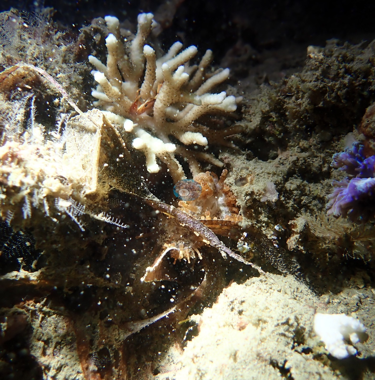
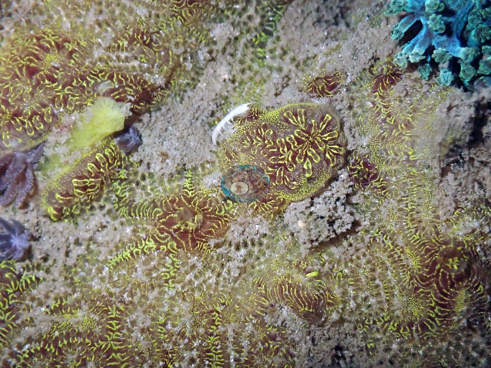
Almost all of them carry bright white branch tips against tan or gold-brown branches -- these are growing tips, not bleaching, and they are the single most likely thing at this site to be misread. A pale-blue to turquoise encrusting patch recurs at the base of several Acropora colonies, and a small blue-purple branching colony sits beside the Acropora in one frame. Fungiid mushroom corals appear four times, twice photographed off the bottom against black water and twice as margin macros ("fungid macro", "bleaching Fungia"), all showing cream-white septal ridges with green-tipped marginal tentacles. A small recruit-scale colony is Anderson's "young pocilloporid", growing among turf with a white tunicate beside it, and another is a bushy pocilloporid-form colony with polyps fully expanded. A pavement of small encrusting polyps with acid-green and yellow oral discs on maroon tissue runs across three frames -- the mat noted in the earlier four-frame pass, here seen to cover substantial areas of rock (e.g., Image 2).
Because it is a night dive, almost every cnidarian in the set is caught with polyps out, and soft corals and fleshy polyp colonies are disproportionately represented: pale pink and cream colonies with feather-tipped, turquoise-green polyps in fifteen frames, a fat lobed white colony ("chubby soft coral"), and dense fields of long cream tentacles in three more.
Coral cover
Coral cover: no figure is published for this site. Night-dive frames are unsuitable for a cover estimate -- they are macro and critter shots under artificial light, not benthic quadrat views -- and no transect or diver survey exists for this site. No number should be read into the site record, and none was derived from these photographs. A cover value will be added if a survey or a computer vision pass becomes available, though this photo set is not a suitable input for one.
Stressors
Sedimentation shows on the corals themselves: "partially buried Acropora" is a small colony half-drowned in sand, and sand sits in the interstices of several thickets. On bleaching, this set has to be read carefully and the honest answer is a qualified one. Four frames are named by Anderson himself as bleaching -- "bleached coral", "bleached polyps", "bleached polyps Kenya", and "bleaching Fungia" -- and those field calls stand. What the imagery independently supports is narrower. The fungiid frames are the strongest: the disc reads as uniformly pale cream-white with the septal ridges standing out sharply, while in the same frame the marginal tentacles still hold clear green pigment, so the pallor of the disc is not simply a torch or color-adjustment wash-out flattening the whole image. The three polyp frames show broad fields of fully expanded, translucent white tentacles, and that is exactly the condition a night dive cannot distinguish from bleaching: extended nocturnal polyps are naturally near-colorless. No frame in the set shows the signatures that would settle it -- bare white skeleton with crisp corallites and no tissue, a tissue-loss margin, or dead skeleton already furred with turf. So bleaching at this site rests on Anderson's own field designation and on the regional context, not on anything the photographs prove on their own. That context is strong: the dive was made at the peak of the 2024 Western Indian Ocean mass bleaching event, in situ temperature averaged 32.0 degrees C with 6 degree heating weeks on the day, and the REEFolution nursery reef a few hundred meters away in the same channel, surveyed the same day, has a published figure of 72.7% of hard coral tissue bleached. No crown-of-thorns starfish, no Drupella aggregations, and no disease lesions appear in any of the 98 frames reviewed. Also on record for this site: Seawater here measured 32.0°C during the survey, and NOAA recorded 6 degree-heating weeks on the day of the dive (Mayfield 2025, Environments 12:276, Table 1).
Fish and other fauna
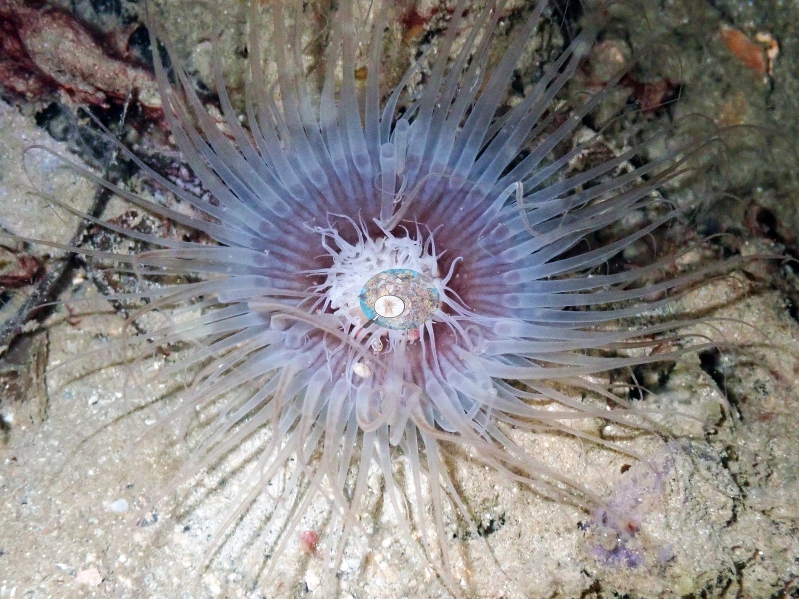
Tube-dwelling cerianthid anemones are the most-photographed single subject on the dive -- at least eight frames, each a white-and-lavender crown of long tentacles spread flat over open sand (e.g., Image 3).
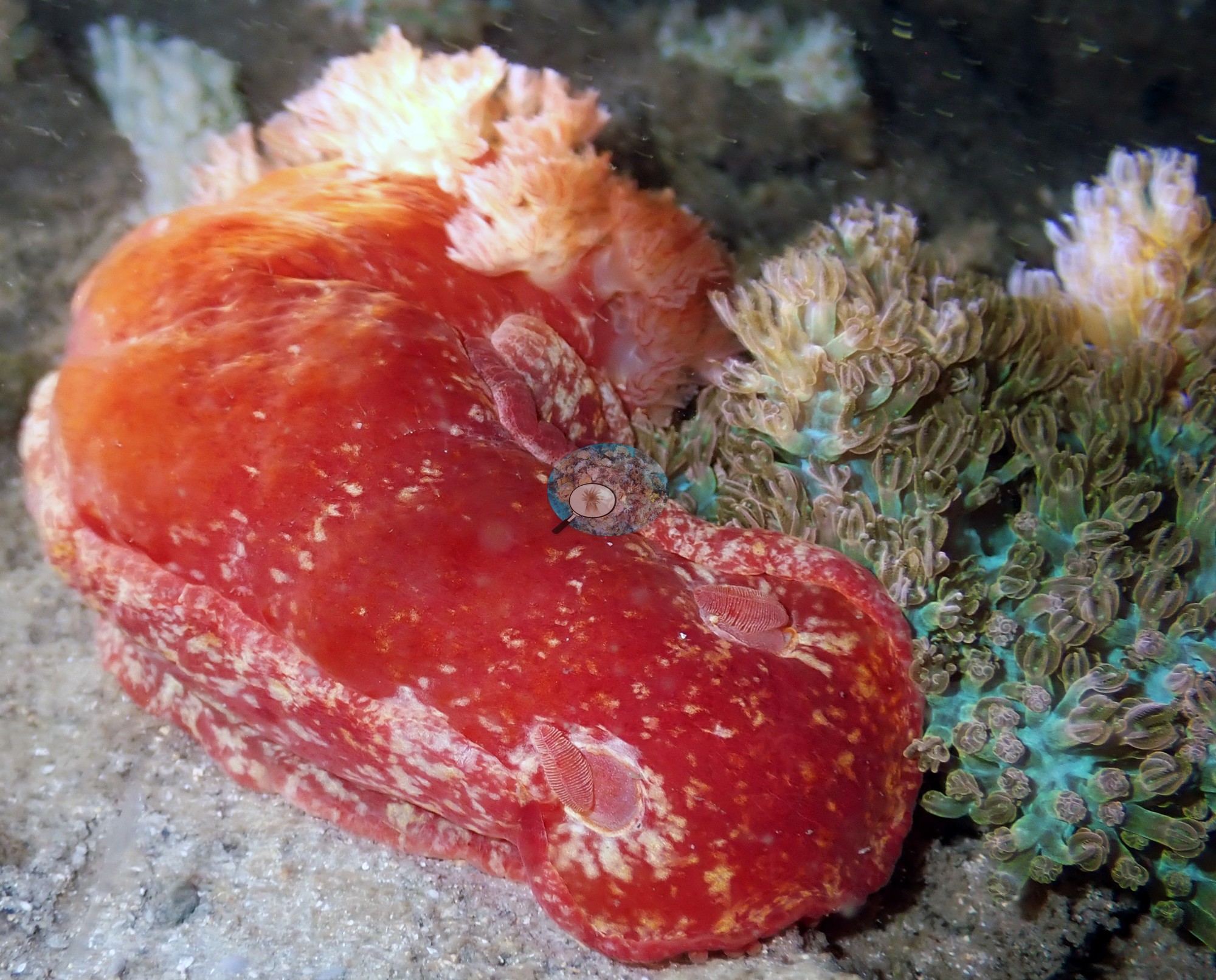
The invertebrate list is the best part of the set. Nudibranchs appear repeatedly: a Spanish dancer, Hexabranchus sanguineus, in scarlet with white mottling and its gill plume erect; a pink-orange dorid with fine red reticulation and white-tipped rhinophores, shot twice; a small slug with purple and orange appendages crawling over an orange sponge; and a dark, ruffle-margined animal photographed twice on rubble. A tiger cowrie is photographed three times, once as a bare polished shell and once with the animal out and the foot extended; a second large gastropod sits out on the reef with its aperture and orange mantle exposed. There are sea cucumbers -- a red-orange one on sand beside green polyps and a big pale-yellow one photographed twice -- plus a translucent red-banded shrimp on sand ("shrimp"), shrimps sheltering inside Acropora branches, a long-antennaed crab on rubble ("crab"), and a crab with green-ringed eyes and spotted legs beside a shell and hydroid. Fish are all night fish. Two moray eels are out of their holes with the jaws open; a blue-gray, white-barred eel is photographed hunting across open sand ("eel", "hunting eel", "Shimoni eel"); a dwarf lionfish or scorpionfish with banded fan pectorals is shot twice; a longhorn cowfish hangs in black water ("cowfish") and a second boxfish-type head appears in "puffer"; a porcupinefish rests on sand with its spines part-raised ("pufferfish"); a parrotfish sleeps wedged into an Acropora thicket; and two frames catch a pink, yellow-eyed fish at rest on the sand. Three frames are labeled seahorse ("sea horse", "seahorse", "seahorse Kenya").
Comparisons with other data
No independent survey was made at this exact site; the nearest ones are listed in the table below.
Dive record
Dived on the night of 20 March 2024 off Shimoni on Kenya's far south coast, in the Shimoni-Wasini channel, as the second dive of Anderson's Shimoni leg -- after the REEFolution nursery that morning and before the Kisite-Mpunguti park sites.
Other notes
This description is rewritten from all 98 photographs of the dive rather than the four-frame published subset. It is a night dive, so most frames are close-focus subjects lit by strobe, but roughly a dozen pull back to colony and thicket scale, and those are enough to settle what the habitat is.
Independent surveys nearby
| Agency / program | Year(s) | Stations / distance | Link |
|---|---|---|---|
| Kenyan reef survey compilation (source not identified) | — | 1 station, 0.52 km | Records ↓ |
| MERMAID project “KenyaBleachingSurveys_2024”* | 2024 | 1 station, 0.73 km | Records ↓ |
| REEFolution Foundation | 2017–2023 | 7 stations, 0.39–3.38 km | Records ↓ |
| WCS Kenya via MERMAID | 2011–2019 | 6 stations, 0.29–4.99 km | Records ↓ |
Within 5 km, 14 independent survey stations recorded hard coral cover in 147 records between 2011 and 2024. Of the 6 stations surveyed in more than one year, 3 declined, 2 increased, and 1 changed by less than 5 percentage points between their first and latest surveys. The longest record, Kikuyu House (REEFolution Foundation, 0.39 km away), went from 32% in 2018 to 23% in 2023. Surveys since 2021 average 34% (range 4.9–66%, n=7). One further row in the table has no survey date, so it is listed but not part of this summary.
Collected by other programs using different methods (MERMAID is a data platform: each MERMAID row names the organization that did the survey, and its method is in the row's hover text. *Conducted by citizen scientists), so these are context for the figures above, not a like-for-like comparison. Where a station was surveyed more than once the range is shown. Station names are not dive-site names.
Show all 15 independent survey records
| Agency | Site / location | Date | Hard coral cover (%) | Distance | Link |
|---|---|---|---|---|---|
| WCS Kenya via MERMAID | Waga | 2011 | 25% (2 images) | 1.76 km | Darling E. 2018. Kenya CRCP legacy. MERMAID |
| WCS Kenya via MERMAID | Waga 2 | 2011 | 25% (2 images) | 1.76 km | Darling E. 2018. Kenya CRCP legacy. MERMAID |
| WCS Kenya via MERMAID | Jiwe la kale East | 2014 | 25% (2 images) | 0.58 km | Darling E. 2018. Kenya CRCP legacy. MERMAID |
| WCS Kenya via MERMAID | Mpunguti | 2016 | 32% (3 images) | 4.99 km | Darling E. 2018. Kenya CRCP legacy. MERMAID |
| REEFolution Foundation | House Reef Firefly | 2017–2021 | 39–66% (21 surveys) | 1.35 km | 2023. REEFolution Kenya. MERMAID |
| REEFolution Foundation | Lower Mpunguti | 2017–2019 | 0.0–8.0% (15 surveys) | 3.38 km | 2023. REEFolution Kenya. MERMAID |
| REEFolution Foundation | Kikuyu House | 2018–2023 | 23–32% (24 surveys) | 0.39 km | 2023. REEFolution Kenya. MERMAID |
| REEFolution Foundation | Pilli Pipa Restaurant | 2018–2023 | 4.9–56% (31 surveys) | 0.66 km | 2023. REEFolution Kenya. MERMAID |
| REEFolution Foundation | Mkwiro CMA | 2018–2023 | 29–37% (7 surveys) | 1.06 km | 2023. REEFolution Kenya. MERMAID |
| REEFolution Foundation | Wasini Tengefu | 2018–2019 | 52–59% (15 surveys) | 2.55 km | 2023. REEFolution Kenya. MERMAID |
| WCS Kenya via MERMAID | Mji wa Kale 1 (Mkwiro) (mean of 2 surveys, 2015–2019) | 2019 | 26% (4 images) | 0.29 km | Darling E, Kosgei J, McClanahan T, Muthiga N. 2019. Kenya MACMON 2016-17. MERMAID |
| WCS Kenya via MERMAID | Mji wa Kale 2 (Mkwiro) (mean of 2 surveys, 2015–2019) | 2019 | 22% (4 images) | 0.58 km | Darling E, Kosgei J, McClanahan T, Muthiga N. 2019. Kenya MACMON 2016-17. MERMAID |
| REEFolution Foundation | Lower Mpunguti (mean of 15 surveys, 2017–2019) | 2019 | 7.1% (15 surveys) | 3.38 km | 2023. REEFolution Kenya. MERMAID |
| MERMAID project “KenyaBleachingSurveys_2024”* | Mji wa Kale 1 (Mkwiro) | 2024 | 36% (2 images) | 0.73 km | Kosgei J, Musembi P. 2024. KenyaBleachingSurveys_2024. MERMAID |
| Kenyan reef survey compilation (source not identified) | Mkwiro (site code S_MR’14), South zone | — | 24% | 0.52 km | — |
Data & links
All images from Coral Reef Diagnostics. Data on this page are from the organizations named in the data-sources table above, not Coral Reef Diagnostics; Coral Reef Diagnostics has no survey of its own at this site.
© Coral Reef Diagnostics.