
Kenya - Sandy Patch/Point (Mombasa)
Part of the regional summary: Kenya
More info
Kenya (NOAA CRW virtual station) · East African Coral Coast ecoregion mean=4.1°C-heating weeksSandy Patch/Point, surveyed during the severe 2024 Western Indian Ocean bleaching event, was the least-bleached of 20 Kenyan sites in this study (45.4% of tissue, against a 77.1% mean across all 20) - a reef of near-continuous foliose and laminar plate corals (Turbinaria, Montipora, Echinopora types) alongside massive domes and abundant soft corals, with a resting green turtle, a camouflaged crocodilefish, and a run of striking nudibranchs on Sinularia. Published cover was 29%, down sharply from a 2017 reading of 54.0% at a nearby station; bleaching here reads as patchy and colony-by-colony rather than sorted cleanly by growth form.
Eneo lililo ndani ya Hifadhi ya Bahari ya Mombasa, kwa kina cha takriban 14 m, lililosomwa kupitia picha 137 katika maji yanayokuwa ya kijani na yenye tope kwenye kina kifupi, na ya buluu na safi zaidi kadiri kina kinavyoongezeka. Upaukaji ni mchanganyiko wa koloni moja baada ya nyingine badala ya kutegemea umbo la ukuaji, na baadhi ya koloni zilizopauka zaidi ni matumbawe makubwa ya mviringo yenye mikunjo (meandroid) na yenye vishimo (cerioid).
Tafsiri ya muhtasari huu kwa AI; Kiingereza ndicho kinachotumika rasmi. Translated from the site’s shorter map summary.
Seventeen independent survey stations shown with the program’s logo — click one to see how far it is from this site.
Two other CRD dive sites within 5 km shown in orange — click a marker to open its page.
3 of these 4 photographs are shown beside the text that discusses them under "Site description" below.
Site description
Setting
Water is Mombasa-typical -- green and plankton- and sediment-laden in the shallower, more sheltered frames, and noticeably bluer and clearer over the deeper bommies, where fusiliers stand out against open blue water. Habitat. The site is not the uniformly thin pavement the earlier four-frame description implied.
General benthic features
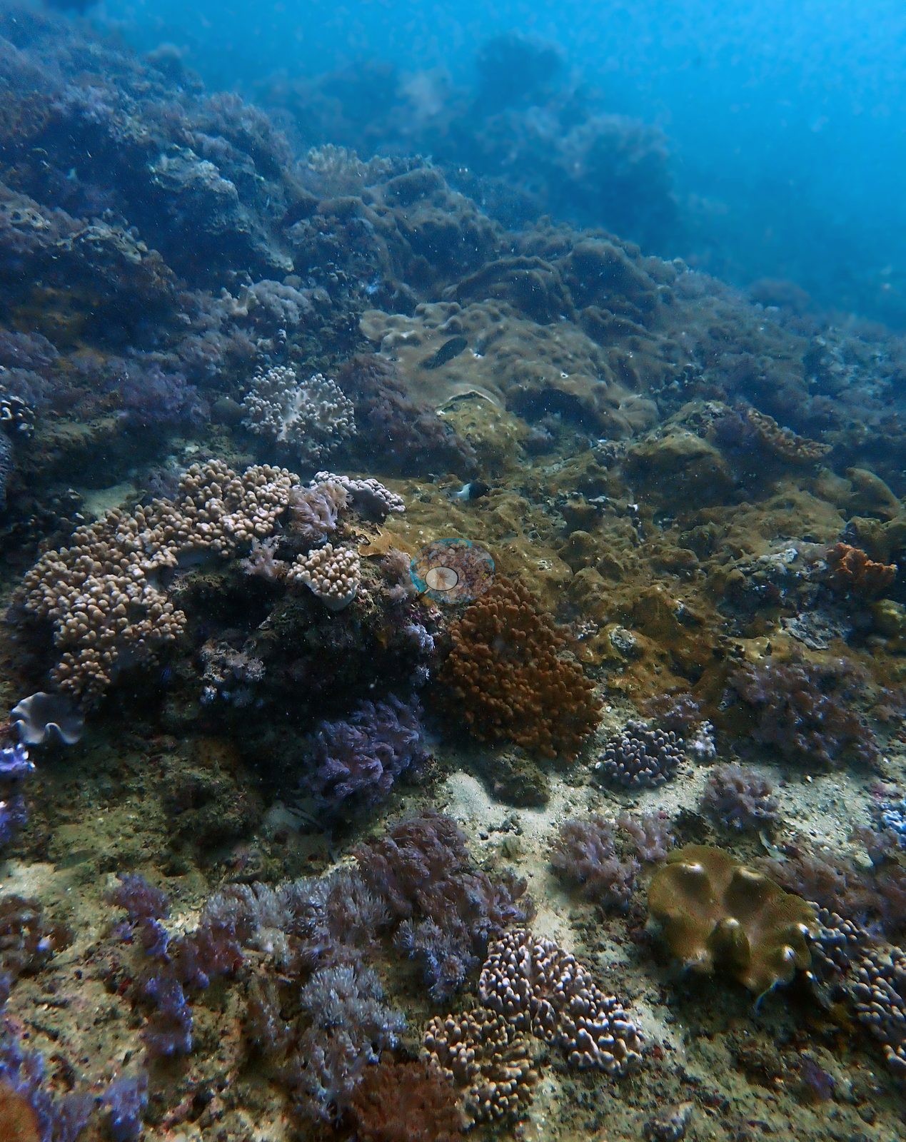
Roughly half the wide frames do show low-relief fringing pavement -- turf- and crustose-coralline-covered rock with sand pockets and scattered colonies, in places heavily algal with only a handful of corals in frame (e.g., Image 1).
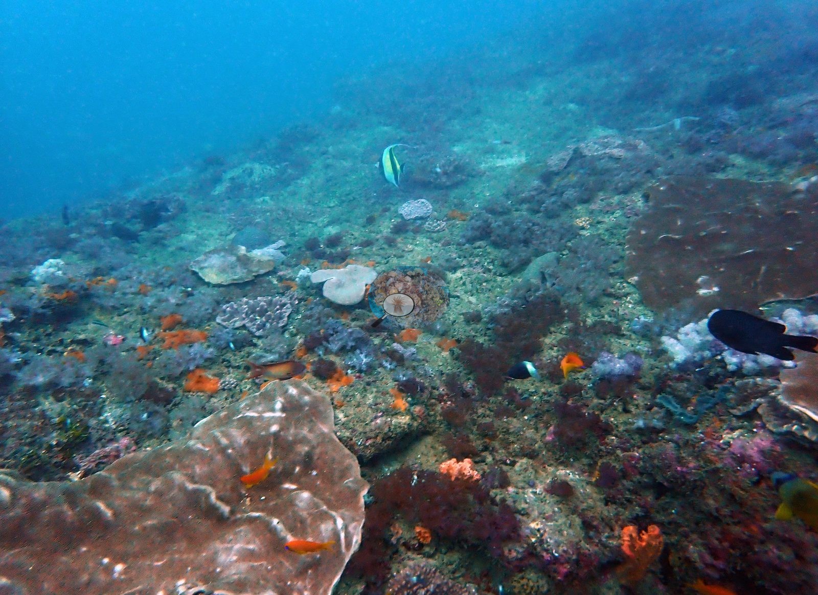
The other half show near-continuous coral: overlapping foliose and laminar plate fields several meters across, large massive domes, and corymbose branching thickets, with a few steeper bommie faces that a diver can swim over. Cover is patchy at the scale of a single swim. Community. Laminar and foliose plate corals dominate -- Turbinaria, Montipora, and Echinopora type plates, plus ridged Merulina/Pachyseris type colonies, many a meter or more across and edged with clean white growing margins. Massives are the second element: cerioid Favites/Goniastrea type colonies, meandroid Platygyra and Symphyllia/Lobophyllia type domes (several in striking violet and lilac), and large Astreopora and Porites boulders. Branching coral is present but subordinate -- corymbose Pocillopora and Acropora, and one bright yellow-green branching Porites stand. Soft corals are conspicuous throughout, as the earlier description said: ruffled Sarcophyton toadstools, digitate Lobophytum and Sinularia, pale lilac Xenia/Anthelia mats, and red, orange, and white Dendronephthya-type colonies on the deeper faces (e.g., Image 2).
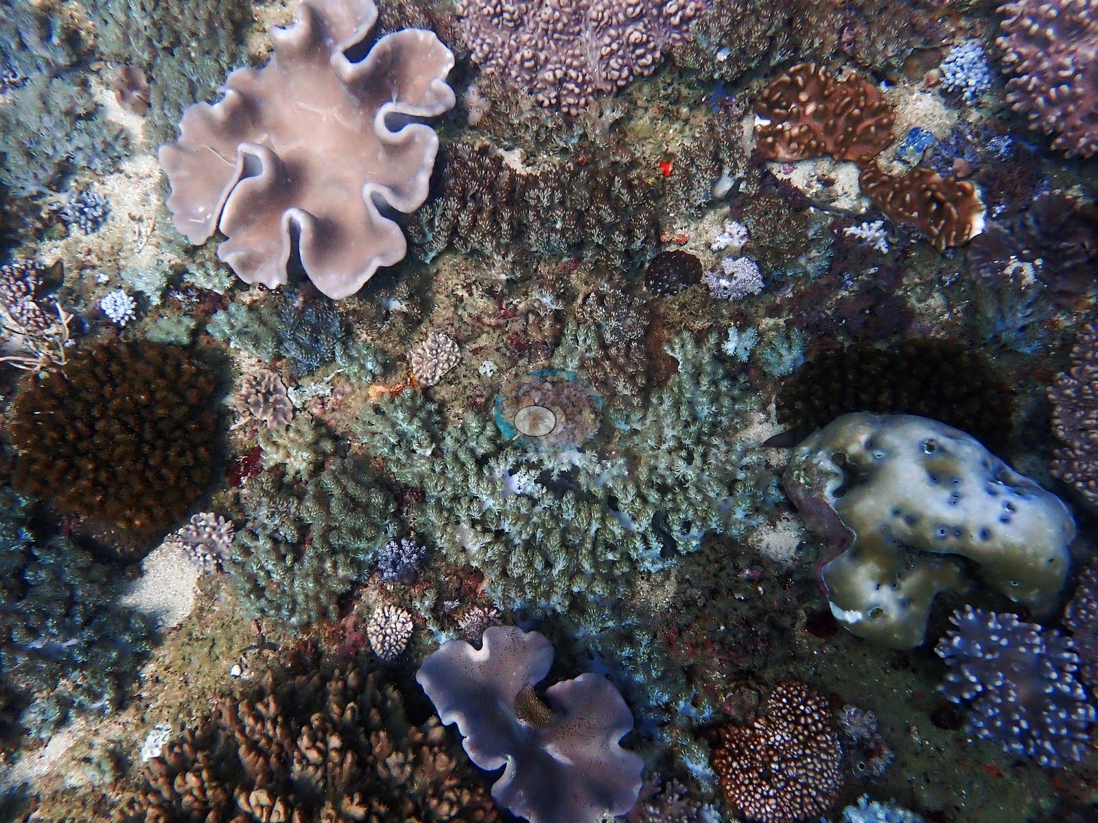
Orange, yellow, and red sponges and pink encrusting coralline are everywhere on the interstitial rock.
Coral cover
Coral cover 29% -- and 45.4% of hard coral tissue bleached (March-April 2024). Measured from 117 white-balanced photographs taken at this site during the 2024 Western Indian Ocean mass bleaching event and point-annotated in CoralNet, published in Mayfield, A.B. (2025) A Citizen Science Approach for Documenting Mass Coral Bleaching in the Western Indian Ocean. Environments 12(8):276. doi:10.3390/environments12080276. This is a published diver-photograph point-annotation value, not a computer vision estimate, and it is not recomputed here. Across the 20 Kenyan sites the mean was 30% coral cover and 77.1% of tissue bleached; Sandy Patch was the least-bleached of them.
Stressors
Condition. Bleaching is visible across the set but partial and mosaic, consistent with this being the least-bleached of the 20 Kenyan sites. The single clearest frame sets a fully pigmented dark chocolate-brown cerioid massive hard against a large pale lilac-blue meandroid colony along a shared margin. Another shows a bone-white ridged plate colony roughly a meter across sitting in otherwise pigmented pavement; a massive Porites is cream-to-mint with one retained salmon pigment patch; and several corymbose Pocillopora and Acropora colonies are stark white or pale cream. However, the earlier statement that bleaching here was sharply growth-form dependent -- hitting the laminar plates hardest while massive and meandroid colonies held pigment -- is not what the full set shows. Many laminar and foliose plates are deeply pigmented dark brown, maroon, and olive, and some of the palest colonies in the whole set are meandroid and cerioid massives. The pattern reads colony-by-colony rather than growth-form-by-growth-form. No crown-of-thorns seastars appear in any frame. A few plate colonies carry white patches that could be recent partial mortality or simply active growing margin; the photographs do not resolve which, and no unambiguous disease lesion is visible. Typical recent thermal stress: mean annual maximum of 4.1 degree heating weeks (2021-2025, NOAA CRW; East African Coral Coast ecoregion). Also on record for this site: Seawater here measured 32.5°C during the survey (the Kenya survey-wide mean of 32.0°C matched the 1998 event), and NOAA recorded a peak of 13.5 degree-heating weeks on 18 April 2024, the highest for Kenya since records began in 1985. In situ temperatures ran 1.3°C above NOAA's estimates, so the true heat stress was likely nearer 22 DHWs.
Fish and other fauna
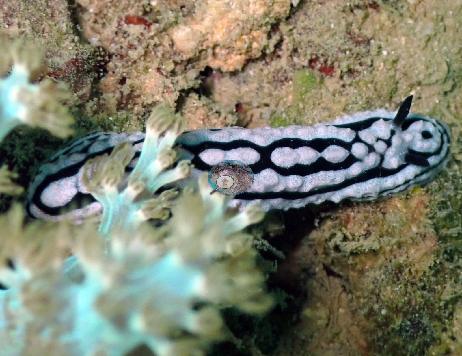
Other life. A green turtle resting on the reef. A crocodilefish, superbly camouflaged on rubble, and a banded spiny lobster under a ledge -- both were already on this site's record and both are now confirmed in the frames. A large trevally and a school of big dark-bodied fish out in the blue; schools of yellow-striped fusiliers and yellowfin snapper; sweetlips, parrotfish, angelfish, a butterflyfish, sergeant majors, and blue chromis; a shoal of silversides over a bommie. Two large tan anemones with fully expanded tentacles, a blue Linckia-type seastar, a Diadema urchin, and a spotted sea cucumber. The dive also produced an unusually good run of phyllidiid nudibranchs, photographed repeatedly on Sinularia: the black-ridged, yellow-tuberculate Phyllidia varicosa type and the white-pustuled Phyllidiella pustulosa type (e.g., Image 4).
Comparisons with other data
No independent survey was made at this exact site; the nearest ones are listed in the table below.
Dive record
Surveyed 11 Mar 2024 at about 14 m with Mombasa Marine Park, during the 2024 Western Indian Ocean mass bleaching event. Surveys were run with Mombasa Marine Park.
Other notes
This account is written from the site's full photographic record rather than the four frames published to the map: 137 frames were opened and read one by one.
CV model comparison
More info
The like-for-like row is the recomputed manual, not the published one. ⚠ The CV columns are on the OLD all-30 denominator while the published manual is on the settled rule; on these frames that understates cover by ~3.0 pp. The 50-frame batch is 6.3 pp poorer in cover than the survey average, so the CV columns are subset-distorted as well as denominator-shifted. Round Reef and Uyombo roll up 15 and 16 quadrat codes respectively. CoralSCOP (SAM-based mask-sum), edited photos: n/a — CoralSCOP was never run on Kenya edited copies; owner's ruling 2026-09-17: 'for kenya, it's only on unedited'| Method | Hard-coral cover (%) |
|---|---|
| Manual (published) | 29.3 |
| CoralNet | 28.8 |
| In-house DINOv3 | 40.0 |
| CoralSCOP unedited | 25.9 |
| Claude | 10.0 |
Independent surveys nearby
| Agency / program | Year(s) | Stations / distance | Link |
|---|---|---|---|
| Mangubhai et al. (2007) | 2003 | 1 station, 1.94 km | Records ↓ |
| McClanahan et al. 2016 | 2016 | 1 station, 4.11 km | Records ↓ |
| WCS Kenya via MERMAID | 2009–2022 | 15 stations, 0.43–4.12 km | Records ↓ |
 Dr. Coral (CRD)Year-average (no detectable trend)
Within 5 km, 17 independent survey stations recorded hard coral cover in 68 records between 2003 and 2022. Of the 1 station surveyed in more than one year, 1 changed by less than 5 percentage points between their first and latest surveys. The longest record, Mombasa (WCS Kenya via MERMAID, 2.48 km away), went from 20% in 2013 to 20% in 2022. One survey since 2021 recorded 20%. This site's own estimate (29%) sits 9.8 points above the recent value (20%); the methods differ, so the comparison is context, not a like-for-like test.
Collected by other programs using different methods (MERMAID is a data platform: each MERMAID row names the organization that did the survey, and its method is in the row's hover text), so these are context for the figures above, not a like-for-like comparison. Where a station was surveyed more than once the range is shown. Station names are not dive-site names.
Show all 17 independent survey records
Data & links
- CoralNet image repository for this region ↗
- HeatCRD database ↗
- (reference) ↗
- Photo portfolio ↗
- Coral Reef Diagnostics page for this area ↗
All images from Coral Reef Diagnostics. Data are from Coral Reef Diagnostics and the organizations named in the data-sources table above.
© Coral Reef Diagnostics.
References
- Mangubhai S, Harrison P, Obura D (2007). Patterns of coral larval settlement on lagoon reefs in the Mombasa Marine National Park and Reserve, Kenya. Marine Ecology Progress Series 348:149-159. PDF
- Mayfield AB (2025). A Citizen Science Approach for Documenting Mass Coral Bleaching in the Western Indian Ocean. Environments 12:276. PDF