
Kenya - Round Reef (Watamu) snorkel

Part of the regional summary: Kenya
More info
Kenya (NOAA CRW virtual station) · East African Coral Coast ecoregion mean=4.1°C-heating weeksRound Reef, surveyed via a systematic 15-quadrat transect for A Rocha, is highly heterogeneous - one quadrat is among the best patches of reef in the whole Kenya study (continuous orange-tan encrusting coral), while another is nearly barren algal turf. Bleaching hit massive Porites and brain corals hardest rather than the branching Acropora, and a striking amount of pigment survived colony by colony, with several quadrats catching a fully pigmented Acropora sitting right beside a bone-white one of the same growth form. Published cover was 18% and bleaching 70.3%, both the lowest of the four Watamu sites in this study, though 70.3% is still well above background.
Utafiti wa picha za viwanja kumi na tano juu ya sakafu ya mwamba na vilele vya vitobo huko Watamu, uliofanywa pamoja na A Rocha kwa nyuzi joto 32.5 C. Porites makubwa na yanayoganda pamoja na matumbawe ya ubongo yenye mikunjo ndiyo yaliyopauka kwa ukamilifu zaidi kuliko matumbawe ya matawi, na angalau picha kumi zinaoanisha Acropora yenye rangi na nyingine nyeupe kama mfupa ndani ya mita moja kutoka…
Tafsiri ya muhtasari huu kwa AI; Kiingereza ndicho kinachotumika rasmi. Translated from the site’s shorter map summary.
Seven independent survey stations shown with the program’s logo — click one to see how far it is from this site.
Three other CRD dive sites within 5 km shown in orange — click a marker to open its page.
Site description
General benthic features
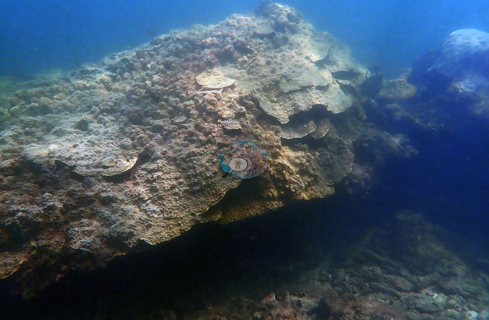
The structural variability the earlier record described holds up, and the quadrats sort it out. RRQ1, RRQ2, and RRQ3 are the high-relief end: coalesced massive-and-encrusting bommies with overlapping plate-like margins under blue-green water (RRQ1-2, RRQ1-3, RRQ1-6, RRQ2-4) (e.g., Image 1).
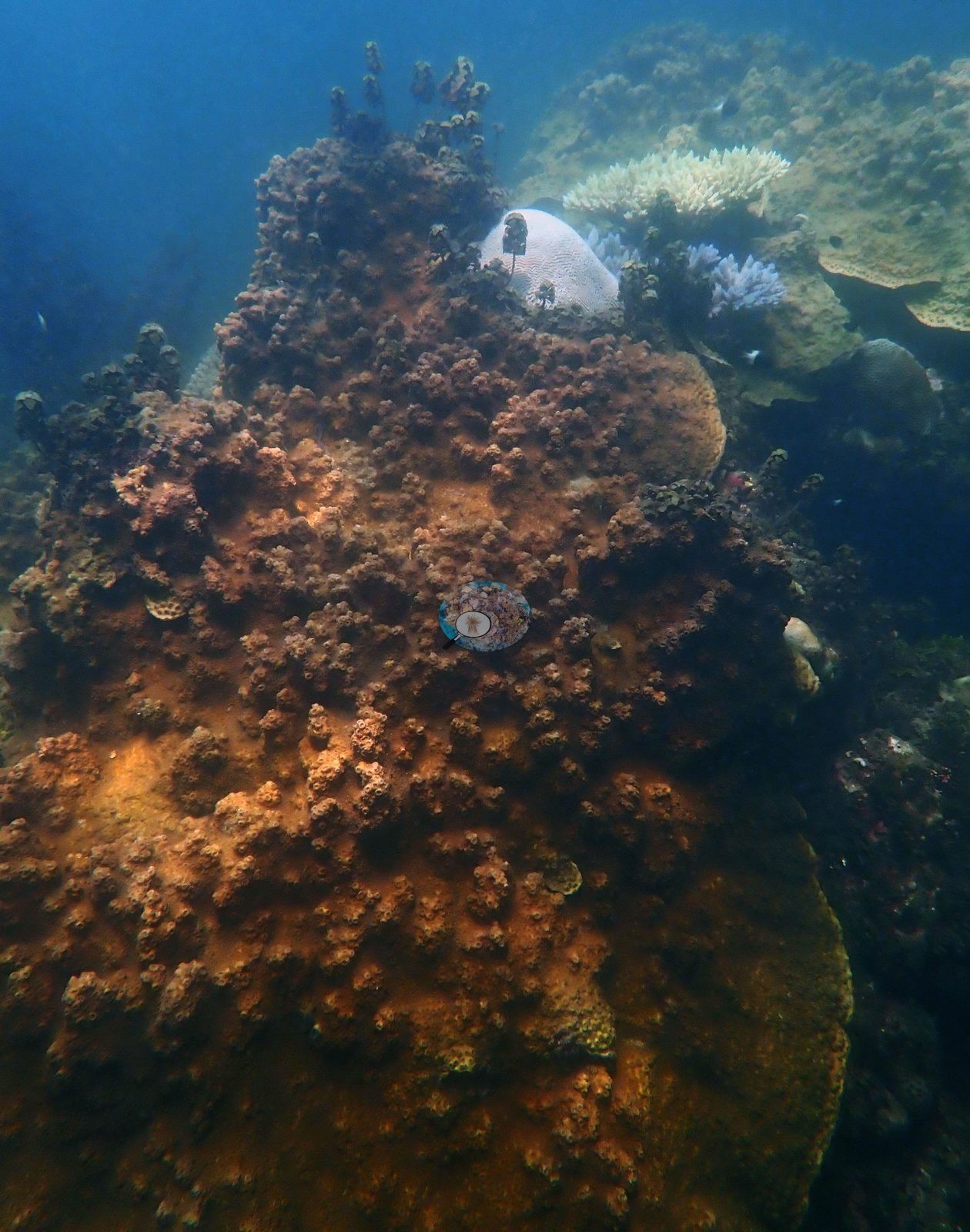
RRQ3 is the best piece of reef in the set -- a bommie face carpeted almost continuously in orange-tan pigmented knobby and encrusting colonies (RRQ3-4, RRQ3-5, RRQ3-10), with yellow-cream foliose plates and magenta crustose coralline in close-up (RRQ3-6) (e.g., Image 2).
At the other end, RRQ15 is close to barren: dense algal turf and pink coralline pavement with no live coral resolvable inside the frame in RRQ15-1, RRQ15-3, or RRQ15-4. RRQ4 and RRQ6 are the turbid, low-visibility stretches -- green water over algae-covered boulders and pink coralline pavement carrying only scattered nubbins (RRQ4-1, RRQ4-2, RRQ6-1, RRQ6-2). The heavy algal canopy is real and is concentrated in RRQ12, RRQ15, and RRQ16: tall brown Sargassum-like fronds standing over the reef in RRQ12-6, RRQ12-7, RRQ12-9, and RRQ12-10, and thick dark-red foliose macroalgae fields in RRQ10-2, RRQ10-5, RRQ11-3, and RRQ7-1. The framework is built around massive Porites-type mounds and meandroid brain corals, with cerioid Goniastrea/Favites-type colonies, foliose plating colonies, corymbose, and digitate Acropora, and cauliflower Pocillopora filling in around them. RRQ9 is the massive-coral quadrat: a meter-scale meandroid brain standing clear of the pavement (RRQ9-12), a stark white dome perched on rock (RRQ9-16), three large pale domes together in blue water (RRQ9-19), and a fully pigmented olive-gold cerioid massive (RRQ9-8). RRQ6 is dominated by one large meandroid brain photographed from four angles (RRQ6-3, RRQ6-4, RRQ6-5, RRQ6-7). Pocillopora is confirmed in the close-ups RRQ14-8 and RRQ14-9, bone-white and sitting directly against a still-green pigmented cerioid colony. Other benthos and fauna: dead framework crusted pink and magenta with coralline algae underlies most of the shallow quadrats (RRQ4-6, RRQ7-8, RRQ8-11, RRQ15-2, RRQ15-4); cream-yellow foliose plating colonies form a distinct group in RRQ7-2, RRQ7-3, RRQ7-4, RRQ8-9, and RRQ3-6; green fleshy and turf algae carpet the shallowest frames (RRQ1-9, RRQ13-9, RRQ9-17).
Coral cover
Read quadrat by quadrat, the site is far more heterogeneous than a single number suggests, and the low published cover is earned in specific places rather than spread evenly. Coral cover 18% -- and 70.3% of hard coral tissue bleached (March-April 2024). Measured from 175 white-balanced photographs taken at this site during the 2024 Western Indian Ocean mass bleaching event and point-annotated in CoralNet, published in Mayfield, A.B. (2025) A Citizen Science Approach for Documenting Mass Coral Bleaching in the Western Indian Ocean. Environments 12(8):276. doi:10.3390/environments12080276. This is a published diver-photograph point-annotation value, not a computer vision estimate. Both figures are the lowest of the four Watamu sites (cover 18% against 20.8-24.8%; bleaching 70.3% against 82.0-95.3%).
Stressors
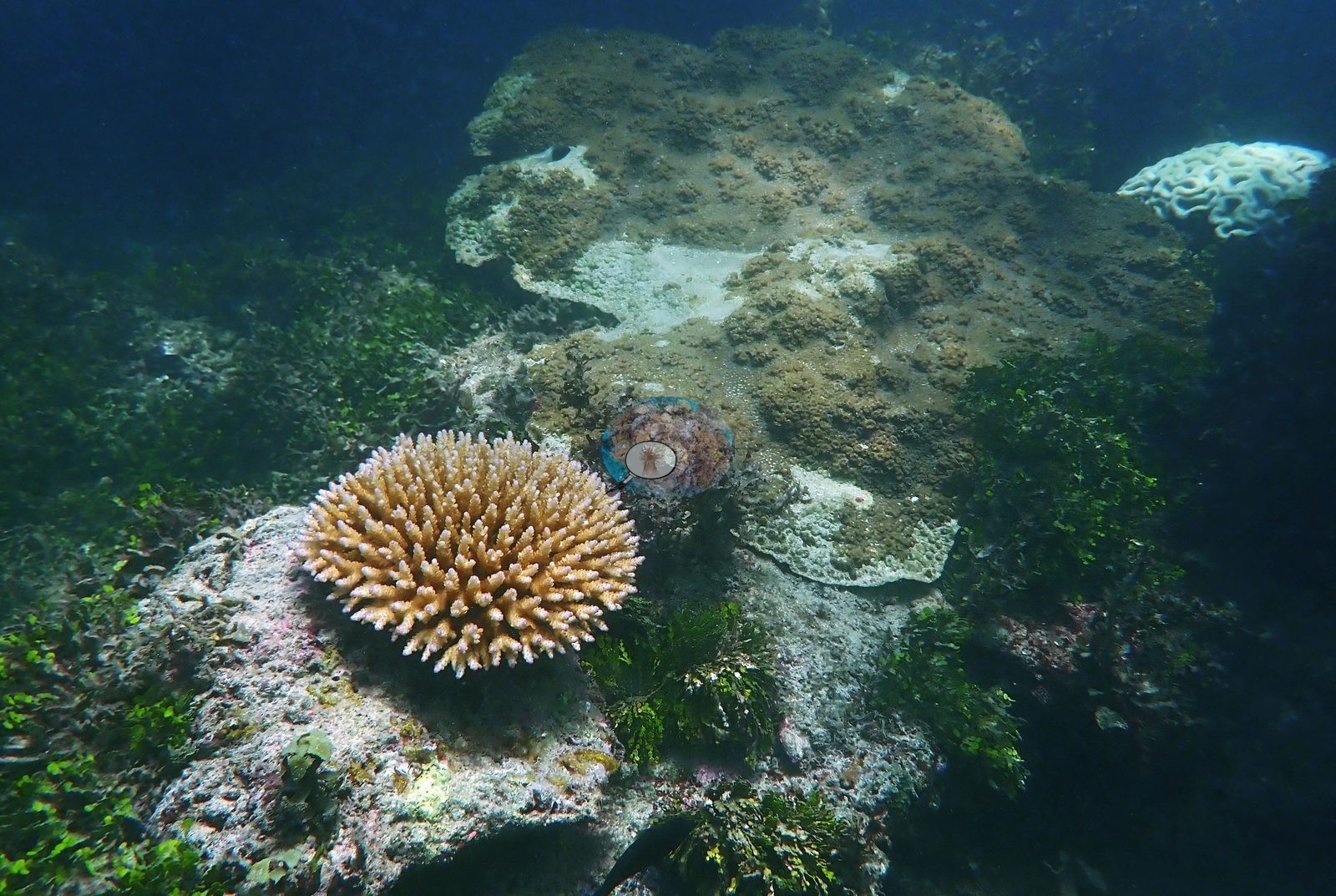
On bleaching, the full set changes the emphasis. Branching corals do carry a large share of it -- white corymbose Acropora recur in RRQ1-7, RRQ10-4, RRQ10-16, RRQ12-3, RRQ12-8, RRQ2-3, RRQ3-8, and RRQ7-9 -- but they are not where the bleaching is worst (e.g., Image 4).
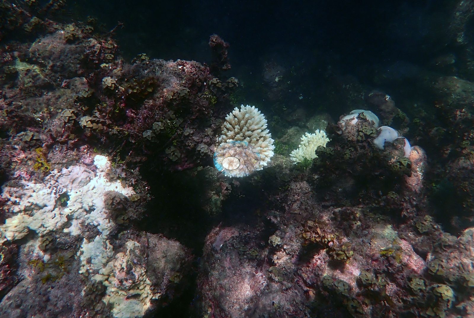
The most completely white colonies at Round Reef are the massives and the brains: a bright white meandroid brain in RRQ1-8, a large white brain beside a still-pigmented cerioid neighbor in RRQ12-2, white massive and lobate Porites in RRQ10-14, RRQ10-17, RRQ2-12, RRQ2-14, RRQ2-15, RRQ12-13, RRQ8-12, RRQ8-13, RRQ9-2, RRQ9-3, RRQ9-9, and RRQ9-16, white encrusting Porites sheets in RRQ6-9 and RRQ8-5, and bleached brains and a bleached cerioid Favites-type colony in RRQ4-5 and RRQ4-7. Partial-colony bleaching is visible too: RRQ9-18 is a brown massive Porites carrying one large irregular white patch, and RRQ10-19 pairs a fully white brain with a partly pigmented corymbose Acropora below it. The genuinely striking thing in this set is how much pigment survived, and how it sits colony by colony rather than by taxon. Fully pigmented gold, tan, and orange-brown corymbose Acropora recur across at least seven quadrats -- RRQ10-12, RRQ10-13, RRQ11-9, RRQ11-10, RRQ12-11, RRQ13-5, RRQ14-1, RRQ14-2, RRQ14-12, RRQ16-1, RRQ16-3, RRQ16-8, RRQ9-10, and RRQ9-17 -- and an orange-brown branching colony in RRQ16-6 is the single healthiest-looking coral in the set, standing in the middle of purple-red macroalgae (e.g., Image 3).
The side-by-side healthy-versus-bleached pair the earlier record singled out is not a one-off: RRQ11-9 and RRQ11-10 each hold a fully pigmented brown corymbose Acropora and a bone-white one of the same growth form on the same patch of pavement, RRQ10-12 and RRQ10-13 show a pigmented orange colony below a white one on the ridge above, and RRQ14-1 and RRQ14-2 catch a gold Acropora and a white one inside the same quadrat frame. Several Acropora sit between the two states, cream with distinct lavender-violet branch tips (RRQ9-4, RRQ9-7, RRQ3-2, RRQ3-3, RRQ3-9) -- the pale-violet cast is consistent across frames and growth forms, though these are color-adjusted exports and the exact hue should not be pressed. Across all 178 frames reviewed there are no crown-of-thorns seastars, no identifiable disease lesions, no predation scars, and no fishing gear or debris. Typical recent thermal stress for the surrounding East African Coral Coast ecoregion is a mean annual maximum of 4.1 degree heating weeks (2021-2025, NOAA CRW), so 2024 was a severe outlier. Seawater here measured 32.5°C during the survey (the Kenya survey-wide mean of 32.0°C matched the 1998 event), and NOAA recorded a peak of 13.5 degree-heating weeks on 18 April 2024, the highest for Kenya since records began in 1985. In situ temperatures ran 1.3 degrees C above NOAA's estimates, so the true heat stress was likely nearer 22 DHWs.
Fish and other fauna
The frames are benthos-focused, but they are not empty of fish: a powder-blue surgeonfish sits beside two pale domes in RRQ2-13, a blue surgeonfish crosses a gold plating colony in RRQ10-20, and small damselfish and chromis appear in RRQ2-4, RRQ9-14, RRQ9-15, RRQ10-17, RRQ11-6, and RRQ16-5. No aggregations, no large macrofauna.
Comparisons with other data
No independent survey was made at this exact site; the nearest ones are listed in the table below.
Dive record
Surveyed 27 Mar 2024 at Round Reef, Watamu, at a logged 1.5 m and 32.5 degrees C, in the middle of the 2024 Western Indian Ocean mass bleaching event, with A Rocha. The full 178-frame set is a quadrat survey, not a swim-through: fifteen PVC frames and meter bars (RRQ1-RRQ4, RRQ6-RRQ16) laid out over reef flat and bommie tops, with the survey team visible in the water in RRQ6-8 and hands with dive slates in RRQ10-3, RRQ16-3, RRQ16-7, RRQ2-5, RRQ3-2, and RRQ8-10. Surveys were run with A Rocha.
CV model comparison
More info
The like-for-like row is the recomputed manual, not the published one. ⚠ The CV columns are on the OLD all-30 denominator while the published manual is on the settled rule; on these frames that understates cover by ~3.0 pp. The 50-frame batch is 6.3 pp poorer in cover than the survey average, so the CV columns are subset-distorted as well as denominator-shifted. Round Reef and Uyombo roll up 15 and 16 quadrat codes respectively. CoralSCOP (SAM-based mask-sum), edited photos: n/a — CoralSCOP was never run on Kenya edited copies; owner's ruling 2026-09-17: 'for kenya, it's only on unedited'| Method | Hard-coral cover (%) |
|---|---|
| Manual (published) | 17.8 |
| CoralNet | 13.7 |
| In-house DINOv3 | 27.7 |
| CoralSCOP unedited | 15.7 |
| Claude | 11.9 |
Independent surveys nearby
| Agency / program | Year(s) | Stations / distance | Link |
|---|---|---|---|
| Global bleaching + environmental database | 2016 | 3 stations, 0.08–0.10 km | Records ↓ |
| Kenyan reef survey compilation (source not identified) | — | 2 stations, 0.14–0.69 km | Records ↓ |
| McClanahan et al. 2016 | 2016 | 3 stations, 0.08–0.10 km | Records ↓ |
| WCS Kenya via MERMAID | 2014–2024 | 4 stations, 0.36–3.93 km | Records ↓ |
 Dr. Coral (CRD)Year-average (no detectable trend)
Within 5 km, 10 independent survey stations recorded hard coral cover in 19 records between 2014 and 2024. Of the 1 station surveyed in more than one year, 1 increased between their first and latest surveys. The longest record, Watamu (WCS Kenya via MERMAID, 0.36 km away), went from 8.8% in 2022 to 15% in 2024. Surveys since 2021 average 13% (range 8.8–16%, n=3). This site's own estimate (18%) is indistinguishable from the recent range (8.8–16%): the 1.9-point gap is inside the ±7 percentage-point noise between methods; the methods differ, so the comparison is context, not a like-for-like test. 2 further rows in the table have no survey date, so they are listed but not part of this summary.
Collected by other programs using different methods (MERMAID is a data platform: each MERMAID row names the organization that did the survey, and its method is in the row's hover text), so these are context for the figures above, not a like-for-like comparison. Where a station was surveyed more than once the range is shown. Station names are not dive-site names.
Show all 13 independent survey records
| Agency | Site / location | Date | Hard coral cover (%) | Distance | Link |
|---|---|---|---|---|---|
| WCS Kenya via MERMAID | Watamu Tewa | 2014 | 20% (2 images) | 1.99 km | Darling E. 2018. Kenya CRCP legacy. MERMAID |
| WCS Kenya via MERMAID | Watamu Canyon | 2014 | 19% | 3.93 km | Darling E. 2018. Kenya CRCP legacy. MERMAID |
| McClanahan et al. 2016 | Watamu South (Kenya) | 2016 | 23% | 0.08 km | — |
| McClanahan et al. 2016 | Watamu south (Kenya) | 2016 | 28% | 0.08 km | — |
| McClanahan et al. 2016 | Watamu north (Kenya) | 2016 | 24% (2 surveys) | 0.10 km | — |
| Global bleaching + environmental database | Watamu South | 2016-04-13 | 23% | 0.08 km | — |
| Global bleaching + environmental database | Watamu north | 2016-04-13 | 27% | 0.10 km | — |
| Global bleaching + environmental database | Watamu south | 2016-05-20 | 28% | 0.08 km | — |
| Global bleaching + environmental database | Watamu north | 2016-05-20 | 21% | 0.10 km | — |
| WCS Kenya via MERMAID | Watamu | 2022–2024 | 8.8–15% (2 images) | 0.36 km | Darling E, Kosgei J, McClanahan T, Muthiga N, Oddenyo R. 2022. Kenya-Marine Monitoring_2022. MERMAID; Hassan J, Julius P, Mensa J, Mkwavila S, Musembi P. 2024. Miamba Yetu Program - Kenya & Tanzania. MERMAID |
| WCS Kenya via MERMAID | Watamu (mean of 6 surveys, 2008–2024) | 2024 | 16% (6 images) | 2.49 km | Darling E. 2018. Kenya CRCP legacy. MERMAID |
| Kenyan reef survey compilation (source not identified) | Watamu Coral Garden (site code C_WCG’15), Central zone | — | 12% | 0.14 km | — |
| Kenyan reef survey compilation (source not identified) | Richard Bennette (site code C_RB’15), Central zone | — | 12% | 0.69 km | — |
Data & links
- CoralNet image repository for this region ↗
- Photo portfolio ↗ Email for access.
- Coral Reef Diagnostics page for this area ↗
All images from Coral Reef Diagnostics. Data are from Coral Reef Diagnostics and the organizations named in the data-sources table above.
© Coral Reef Diagnostics.