
Kenya - Reefolution nursery (Shimoni-Wasini)

Part of the regional summary: Kenya
More info
Kenya (NOAA CRW virtual station) · East African Coral Coast ecoregion mean=4.1°C-heating weeksThis REEFolution restoration site in the Shimoni-Wasini channel pairs an engineered coral nursery - rope trees, rebar frames, and concrete modules bearing outplanted Acropora fragments - with the natural fringing reef around it, heavily overgrown with fleshy macroalgae. Bleaching on the nursery stock was patchy, with pigmented and stark-white fragments hanging side by side on the same structure, while on the natural reef massive Porites domes largely held their color even as brain corals went mostly bone-white and branching Acropora and Pocillopora took the worst damage, some already dead and turf-covered. Published cover was 40% with 72.7% of hard coral tissue bleached.
Eneo la urejeshaji wa matumbawe la REEFolution katika mkondo wa Shimoni-Wasini, lililopigwa picha kama vitu viwili kwa wakati mmoja: mpangilio uliobuniwa wa miti ya kamba, fremu za nondo na moduli za saruji, pamoja na mwamba wa asili unaouzunguka. Vipandikizi vingi vya kitalu vina rangi badala ya kupauka na viko katika hali bora kuliko mwamba wa asili ulio jirani, ingawa…
Tafsiri ya muhtasari huu kwa AI; Kiingereza ndicho kinachotumika rasmi. Translated from the site’s shorter map summary.
Thirteen independent survey stations shown with the program’s logo — click one to see how far it is from this site.
Three other CRD dive sites within 5 km shown in orange — click a marker to open its page.
3 of these 4 photographs are shown beside the text that discusses them under "Site description" below.
Site description
Setting
Visibility is not uniform across the set. A large block of frames is green, milky, and heavily particle-laden with only a few meters of horizontal range, but many others -- the tree frames, the tabular-Acropora arrays, several reef panoramas -- are shot in blue water with the far end of a nursery structure still resolvable, so the day ranged from murky to reasonably clear rather than being uniformly bad.
General benthic features
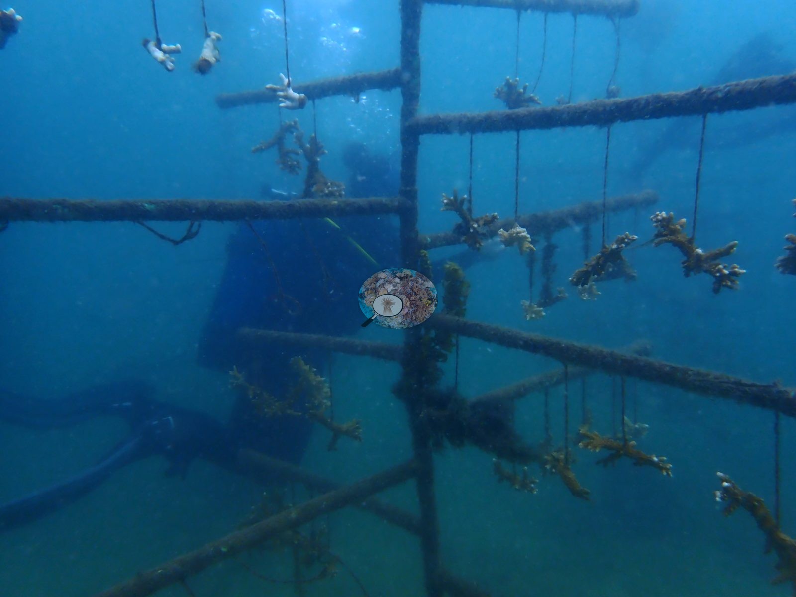
The nursery is more varied than a single frame suggests. Four distinct kinds of structure appear. (1) Rope trees: vertical trunks with horizontal steel cross-bars, fragments hung on individual short droppers -- exactly the hanging-nursery design, photographed repeatedly (e.g., Image 1).
(2) Rigid welded rebar frames and A-frame tables with fragments fixed directly onto the bars, several now carrying grown-out branching and tabulate Acropora that has fused across the metal. (3) Cast concrete modules -- squat cylindrical plinths, tiered "cake-stand" and stepped ziggurat blocks, and long ladder-like concrete beams with small fragments cemented onto the upper faces. (4) A bottle-and-cement substrate carrying fire coral, Millepora, in mustard-yellow branching plates ("fire coral on bottles"). One frame (with its duplicates) shows the mature end of the program: three tiers of broad tabulate Acropora plates, each a meter or so across, stacked above one another on the array in open water. The natural reef around the array is a low-relief carbonate hardground with heavy macroalgal load. Whole frames are given over to brown fleshy algae -- Sargassum and Dictyota-type turf -- overtopping the substrate ("too much macroalgae", "algal smothering", "algal smothering reef", "dying reef"). The stony fauna on it splits sharply by growth form. Foliose and encrusting agariciids, Galaxea with brown-and-white tipped tentacles, and mustard Turbinaria plates round out the assemblage. Soft corals and a pigmented purple-brown Tridacna giant clam are among the few saturated colors in the wide shots.
Coral cover
Coral cover 40% -- and 72.7% of hard coral tissue bleached (March-April 2024). Measured from 258 white-balanced photographs taken at this site during the 2024 Western Indian Ocean mass bleaching event and point-annotated in CoralNet, published in Mayfield, A.B. (2025) A Citizen Science Approach for Documenting Mass Coral Bleaching in the Western Indian Ocean. Environments 12(8):276. doi:10.3390/environments12080276. This is a published diver-photograph point-annotation value, not a computer vision estimate, and it covers the natural reef as photographed -- it is not a measure of nursery stock.
Stressors
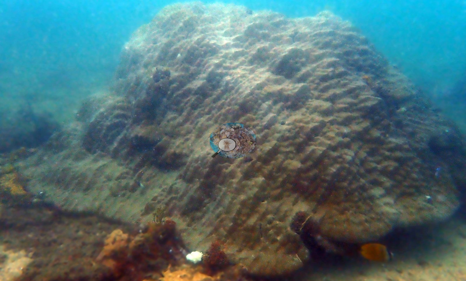
Nursery stock condition is the interesting part, and it is patchy rather than uniformly bad. Across the array most fragments and grown-out colonies are pigmented -- dense tan, gold-brown, and rust-brown Acropora, some corymbose, some staghorn, some tabulate, several with pale-blue or white growing tips that read as growth rather than bleaching. Against that, individual colonies and whole droppers are stark white with corallite structure still crisp and no algal film -- bleached but alive -- and the two states sit side by side on the same bar at the same depth. One frame catches it best: one table half rust-brown and half bone-white along a sharp margin. A minority of frames show the failure end of the range: the "dying nursery" tree, where most droppers hang bare or carry only pale stubs, and one with whitened fragments on an otherwise stripped bar. So the picture is neither "the nursery was fine" nor "the nursery was dying" -- on this day, on these structures, bleaching was strongly colony-by-colony. Massive Porites domes, some several meters across, are still fully pigmented in dull olive, gold, and tan and appear repeatedly (e.g., Image 3).
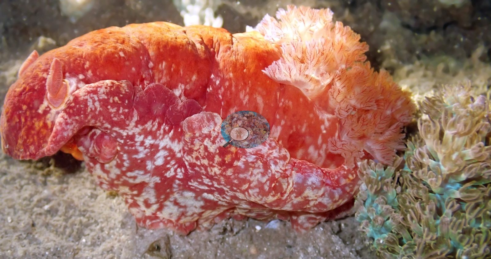
Meandroid brains -- Platygyra and relatives -- are mostly bone-white with the ridge-and-valley surface intact ("bleached brains", "Kenya bleaching 2024", "bleached corallites"), though "mystery coral" shows a fully pigmented pink-and-cream Platygyra a few frames away (e.g., Image 2).
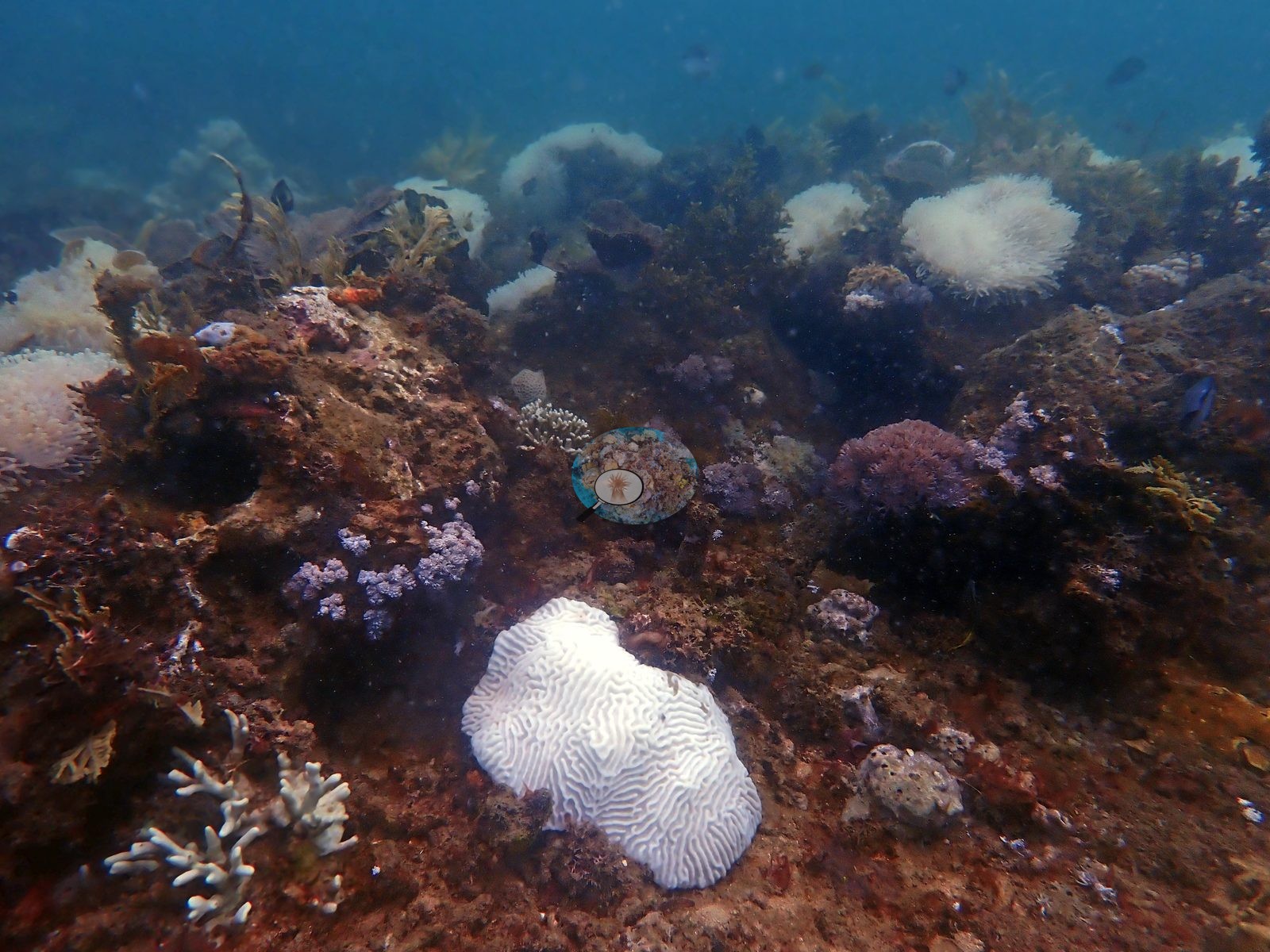
Lobophyllia is bleached white with the fleshy lobes still turgid ("bleached Lobophyllia", "Lobophyllia polyps"). Branching Acropora and Pocillopora on the natural reef carry the highest apparent damage: fields of white staghorn, white corymbose colonies, and a bleached bushy Seriatopora, plus pocilloporids that are past bleaching and into death, their skeletons furred with turf ("dead pocilloporid", "dead pocilloporid Kenya"). Anemones are conspicuously affected -- several large host anemones are white to blush-pink with tentacles extended, one still holding an anemonefish. Because the frames are color-adjusted, bleaching here is called on structure, not on hue: bare white surfaces with crisp corallites and no algal film (bleached, tissue alive), against dull white or gray surfaces already furred with turf and red algae (recently dead). Both are present, side by side, and the split between them is the clearest signal in the set. Typical recent thermal stress: mean annual maximum of 4.1 degree heating weeks (2021-2025, NOAA CRW; East African Coral Coast ecoregion). Also on record for this site: Seawater here measured 32.0°C during the survey (the Kenya survey-wide mean of 32.0°C matched the 1998 event), and NOAA recorded a peak of 13.5 degree-heating weeks on 18 April 2024, the highest for Kenya since records began in 1985. In situ temperatures ran 1.3°C above NOAA's estimates, so the true heat stress was likely nearer 22 DHWs. No crown-of-thorns starfish (COTS) or other corallivores evident.
Fish and other fauna
A handful are subjects rather than habitat: a flying gurnard fanning its wings on sand, a blue-legged hermit crab photographed twice, a pufferfish, a giant clam, and two frames of divers working the array.
Comparisons with other data
No independent survey was made at this exact site; the nearest ones are listed in the table below.
Dive record
Dived 20 March 2024 at about 5 m in the Shimoni-Wasini channel, on and around REEFolution's restoration site, at the height of the 2024 Western Indian Ocean mass bleaching event. Surveys were run with REEFolution.
Other notes
This description is rewritten from all 206 photographs of the dive rather than the eight-frame published subset, and the site turns out to be two things photographed together: an engineered nursery/outplant array, and the natural fringing reef it sits on. Roughly thirty frames are close-focus macro of pocilloporid and acroporid polyps, mostly pale to white and many soft-focus; three are blue-light fluorescence images (a green-glowing meandroid brain, glowing polyp mouths, an anemone) and carry no cover information at all.
CV model comparison
| Method | Hard-coral cover (%) |
|---|---|
| Manual (published) | 40.2 |
| CoralNet | 39.6 |
| In-house DINOv3 | 43.8 |
| CoralSCOP unedited | 16.3 |
Independent surveys nearby
| Agency / program | Year(s) | Stations / distance | Link |
|---|---|---|---|
| Kenyan reef survey compilation (source not identified) | — | 1 station, 0.27 km | Records ↓ |
| MERMAID project “KenyaBleachingSurveys_2024”* | 2024 | 1 station, 0.99 km | Records ↓ |
| REEFolution Foundation | 2017–2023 | 7 stations, 0.24–3.77 km | Records ↓ |
| WCS Kenya via MERMAID | 2011–2019 | 5 stations, 0.44–1.77 km | Records ↓ |
 Dr. Coral (CRD)Year-average (no detectable trend)
Within 5 km, 13 independent survey stations recorded hard coral cover in 144 records between 2011 and 2024. Of the 6 stations surveyed in more than one year, 3 declined, 2 increased, and 1 changed by less than 5 percentage points between their first and latest surveys. The longest record, Pilli Pipa Restaurant (REEFolution Foundation, 0.24 km away), went from 28% in 2018 to 4.9% in 2023. Surveys since 2021 average 34% (range 4.9–66%, n=7). This site's own estimate (40%) sits within the recent range (4.9–66%); the methods differ, so the comparison is context, not a like-for-like test. One further row in the table has no survey date, so it is listed but not part of this summary.
Collected by other programs using different methods (MERMAID is a data platform: each MERMAID row names the organization that did the survey, and its method is in the row's hover text. *Conducted by citizen scientists), so these are context for the figures above, not a like-for-like comparison. Where a station was surveyed more than once the range is shown. Station names are not dive-site names.
Show all 14 independent survey records
| Agency | Site / location | Date | Hard coral cover (%) | Distance | Link |
|---|---|---|---|---|---|
| WCS Kenya via MERMAID | Waga | 2011 | 25% (2 images) | 1.77 km | Darling E. 2018. Kenya CRCP legacy. MERMAID |
| WCS Kenya via MERMAID | Waga 2 | 2011 | 25% (2 images) | 1.77 km | Darling E. 2018. Kenya CRCP legacy. MERMAID |
| WCS Kenya via MERMAID | Jiwe la kale East | 2014 | 25% (2 images) | 0.87 km | Darling E. 2018. Kenya CRCP legacy. MERMAID |
| REEFolution Foundation | House Reef Firefly | 2017–2021 | 39–66% (21 surveys) | 1.25 km | 2023. REEFolution Kenya. MERMAID |
| REEFolution Foundation | Lower Mpunguti | 2017–2019 | 0.0–8.0% (15 surveys) | 3.77 km | 2023. REEFolution Kenya. MERMAID |
| REEFolution Foundation | Pilli Pipa Restaurant | 2018–2023 | 4.9–56% (31 surveys) | 0.24 km | 2023. REEFolution Kenya. MERMAID |
| REEFolution Foundation | Kikuyu House | 2018–2023 | 23–32% (24 surveys) | 0.60 km | 2023. REEFolution Kenya. MERMAID |
| REEFolution Foundation | Mkwiro CMA | 2018–2023 | 29–37% (7 surveys) | 1.29 km | 2023. REEFolution Kenya. MERMAID |
| REEFolution Foundation | Wasini Tengefu | 2018–2019 | 52–59% (15 surveys) | 2.17 km | 2023. REEFolution Kenya. MERMAID |
| WCS Kenya via MERMAID | Mji wa Kale 1 (Mkwiro) (mean of 2 surveys, 2015–2019) | 2019 | 26% (4 images) | 0.44 km | Darling E, Kosgei J, McClanahan T, Muthiga N. 2019. Kenya MACMON 2016-17. MERMAID |
| WCS Kenya via MERMAID | Mji wa Kale 2 (Mkwiro) (mean of 2 surveys, 2015–2019) | 2019 | 22% (4 images) | 0.84 km | Darling E, Kosgei J, McClanahan T, Muthiga N. 2019. Kenya MACMON 2016-17. MERMAID |
| REEFolution Foundation | Lower Mpunguti (mean of 15 surveys, 2017–2019) | 2019 | 7.1% (15 surveys) | 3.77 km | 2023. REEFolution Kenya. MERMAID |
| MERMAID project “KenyaBleachingSurveys_2024”* | Mji wa Kale 1 (Mkwiro) | 2024 | 36% (2 images) | 0.99 km | Kosgei J, Musembi P. 2024. KenyaBleachingSurveys_2024. MERMAID |
| Kenyan reef survey compilation (source not identified) | Mkwiro (site code S_MR’14), South zone | — | 24% | 0.27 km | — |
Data & links
- CoralNet image repository for this region ↗
- Photo portfolio ↗
- Coral Reef Diagnostics page for this area ↗
All images from Coral Reef Diagnostics. Data are from Coral Reef Diagnostics and the organizations named in the data-sources table above.
© Coral Reef Diagnostics.