
Kenya - Outer Kisite (Kisite National Park)

Part of the regional summary: Kenya
More info
Tanzania (NOAA CRW virtual station) · East African Coral Coast ecoregion mean=4.1°C-heating weeksOuter Kisite is a high-relief reef of long coral ridges and buttresses where bleaching sorted sharply by growth form: massive Porites hillsides and foliose plate terraces stayed largely pigmented, while the branching and corymbose Acropora thickets on the crest took the damage, with entire beds gone bone-white. An enormous school of bluestripe snapper, an octopus in a rubble den, and a hawksbill turtle resting beneath a soft-coral overhang were fauna highlights. Published cover was 37% with 66.2% of coral tissue bleached, down from 46.3% at a nearby 2016 survey.
Upande wa nje wa Hifadhi ya Taifa ya Bahari ya Kisite kwa nyuzi joto 31.6 C, ambapo vilima halisi vya Porites makubwa na matuta ya matumbawe ya sahani yaliyopangana kama vigae yote ni mengi. Upaukaji umepangika kwa nguvu kufuatana na umbo la ukuaji: Acropora ya matawi kwa wingi ni meupe ilhali vilima vya Porites na matuta ya sahani vilishikilia rangi.
Tafsiri ya muhtasari huu kwa AI; Kiingereza ndicho kinachotumika rasmi. Translated from the site’s shorter map summary.
Fifteen independent survey stations shown with the program’s logo — click one to see how far it is from this site.
Five other CRD dive sites within 5 km shown in orange — click a marker to open its page.
Site description
Setting
Visibility is moderate and blue-green, hazier than at Coral Garden, with a persistent green cast over the deeper background in many wide frames. Habitat. A big, high-relief structure: long coral ridges and buttresses running out and down, separated by sand- and rubble-floored channels, with a coral-dense crest that the wide frames show as near-continuous living cover for meters at a stretch. Several frames look straight down the flank of a ridge from the crest into open blue; others sit on the sand at the base looking up at a wall of coral.
General benthic features
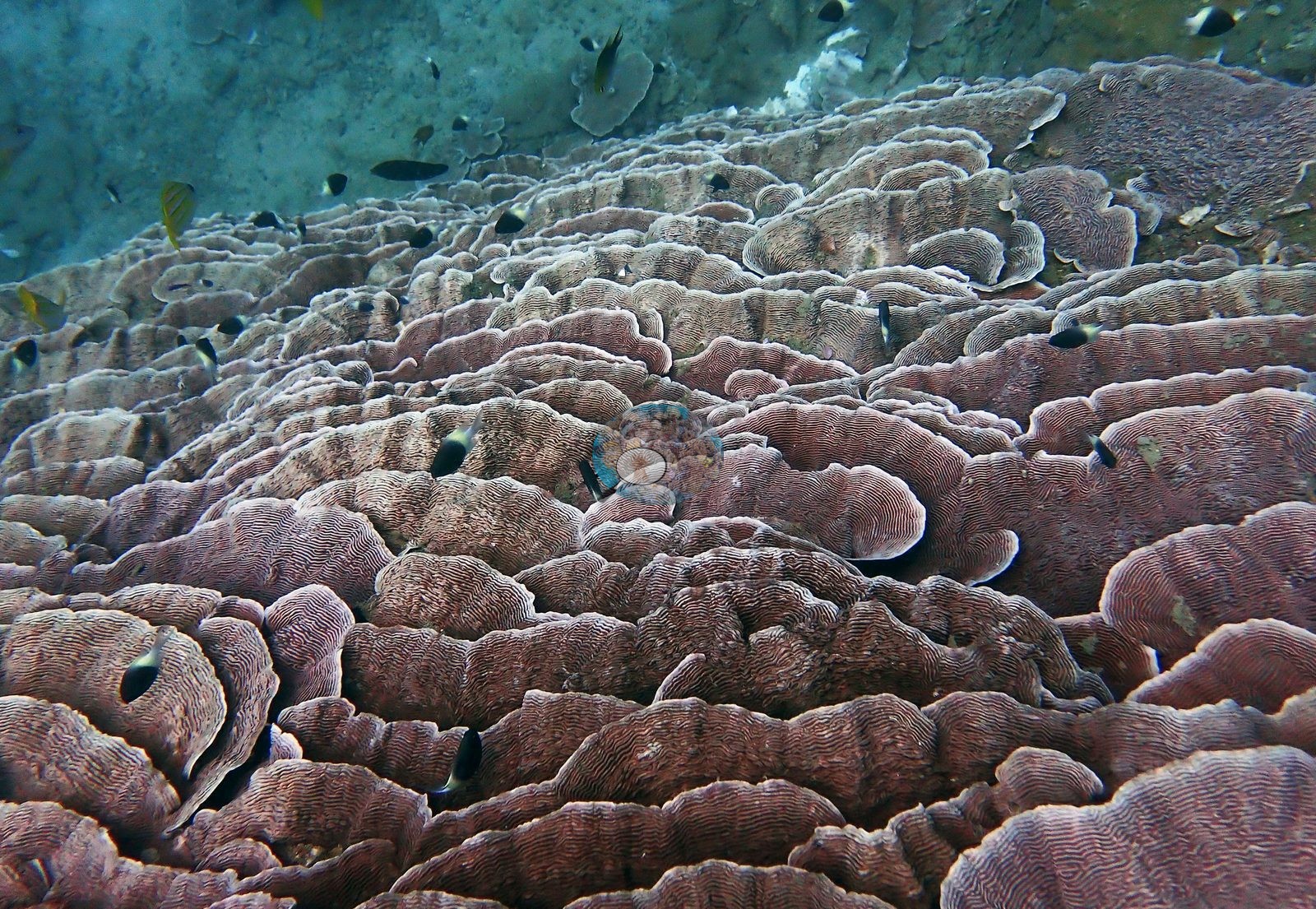
Between the ridges are rubble aprons of broken branch fragments and coralline-crusted pavement, and a few genuinely bare sand patches. Growth-form mosaic. Four elements repeat across the set and between them account for most of what is in frame. Massive nodular Porites-type hillsides. Whole slope faces are covered by a single knobby, close-packed massive coral in brown-mauve, knob after rounded knob to the edge of frame with only small pale cerioid Goniastrea/Favites-type colonies wedged into the gaps. This is the near-monospecific hillside the site's earlier record described, and the full set confirms it: it is massive Porites-type coral, not plate coral. Shingled foliose plate terraces. Just as abundant and just as characteristic: whorled, crisped plates overlapping plate on plate for the whole frame, every surface sculpted with fine concentric ridges and edged in pale cream (e.g., Image 2).
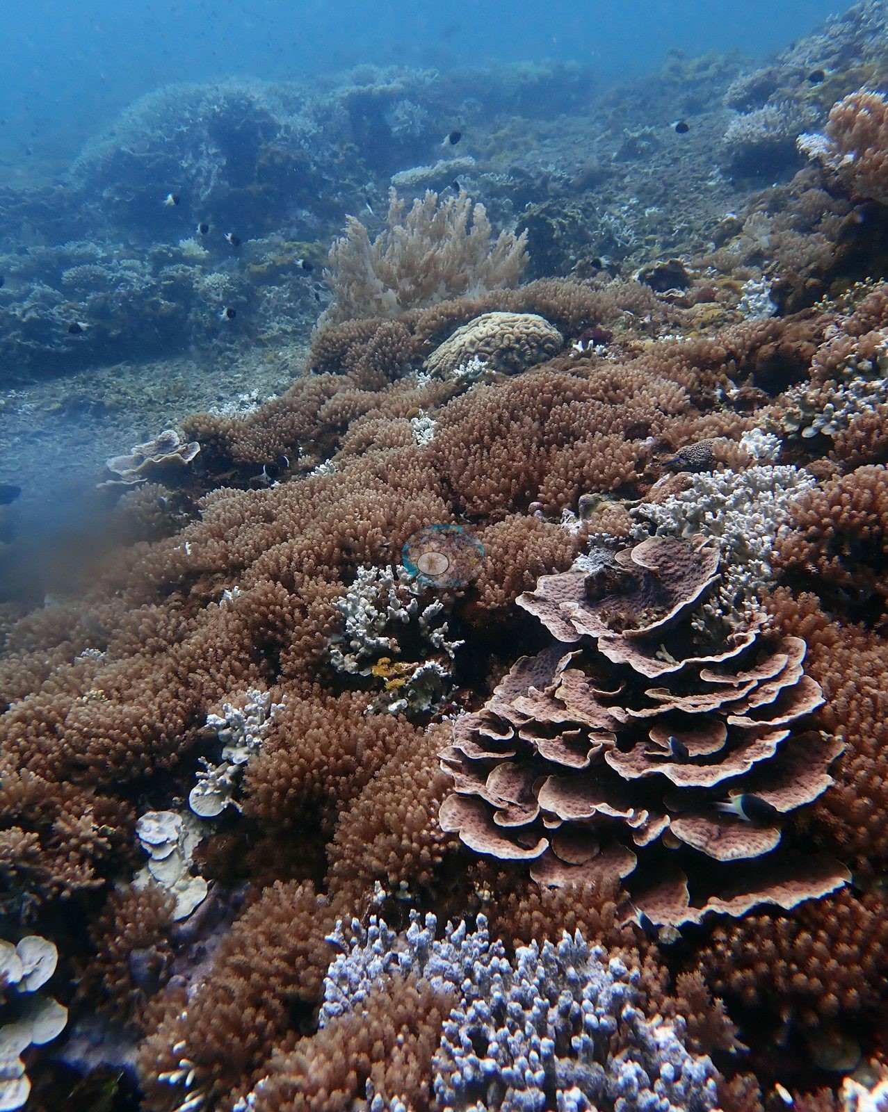
Color runs dusty mauve-pink to brick-brown -- pigmented, if muted. One superb rosette colony a meter or more across sits alone on rubble. The concentric-ridge sculpture is consistent with Pachyseris/Merulina- or Echinopora-type taxa but is not resolvable to genus at this range, so growth form is what is claimed here. Branching and corymbose Acropora thickets. The crest and upper slope carry dense corymbose, digitate, and staghorn Acropora (e.g., Image 1).
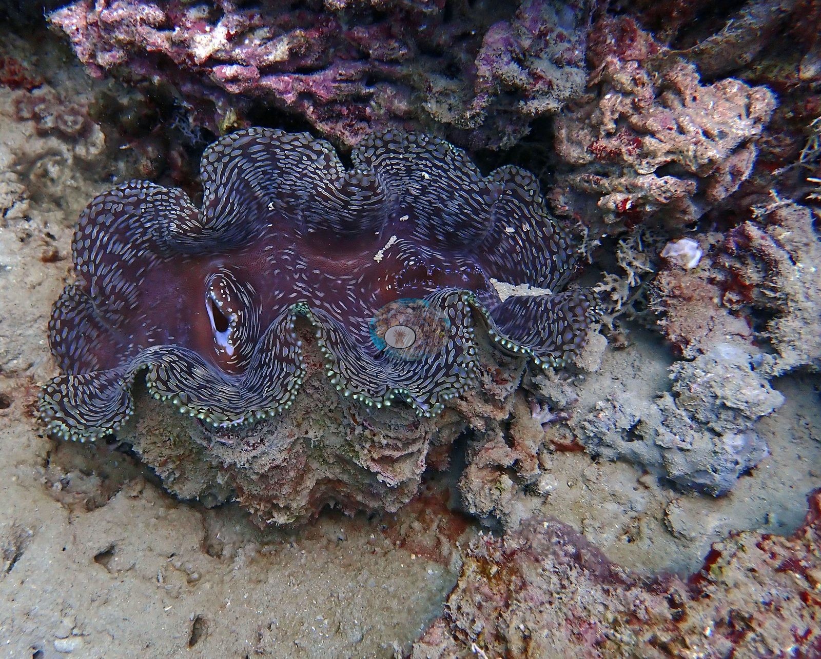
Meandroid brain corals. Scattered rather than dominant but conspicuous: a large cream-and-tan Platygyra-type dome resting on sand, a smaller salmon-pink meandroid colony ringed by bleached-white neighbors and soft coral, and a broad meandroid pavement into which a giant clam is set. Elsewhere, feathery red and pink Dendronephthya-type soft corals stand on the sand, red and orange encrusting sponges fill the interstitial rock, and a sea cucumber lies across a bleached Acropora bed.
Coral cover
Coral cover 37% -- and 66.2% of hard coral tissue bleached (March-April 2024). Measured from 85 white-balanced photographs taken at this site during the 2024 Western Indian Ocean mass bleaching event and point-annotated in CoralNet, published in Mayfield, A.B. (2025) A Citizen Science Approach for Documenting Mass Coral Bleaching in the Western Indian Ocean. Environments 12(8):276. doi:10.3390/environments12080276. This is a published diver-photograph point-annotation value, not a computer vision estimate, and it is not recomputed here.
Stressors
One isolated dome on sand is a textbook of partial bleaching -- the same knob texture throughout, but irregular chalk-white and pale-mint zones bleeding across a mauve-brown colony, with no tissue loss. This is the growth form the heat took. Frame after frame shows beds of bone-white and pale-lavender branching colonies -- skeletal architecture intact, branch tips sharp, no algal fouling, which reads as fresh bleaching rather than old mortality -- interleaved with tan and olive colonies that held pigment. The single most telling frame sets a fully pigmented yellow-green corymbose dome directly against a bed of stark white branching Acropora, margin to margin. Condition. Bleaching is unmistakable and widespread in the set, and it is strongly growth-form structured. The branching and corymbose Acropora stands are the casualties -- in several frames the majority of branching colonies in view are white. The massive Porites hillsides and the foliose plate terraces are, by contrast, largely pigmented, with bleaching on them showing as patches on otherwise colored colonies rather than whole-colony whitening; one bleached foliose plate colony and one bleached tabular plate do appear. Older mortality is present too: at least one large plate colony is entirely dead and carpeted in turf and sediment, and the rubble aprons are made of branch fragments. No crown-of-thorns seastar appears in any of the 87 frames, and no unambiguous disease lesion is visible. Typical recent thermal stress: mean annual maximum of 4.1 degree heating weeks (2021-2025, NOAA CRW; East African Coral Coast ecoregion). Also on record for this site: Seawater here measured 31.6°C during the survey (the Kenya survey-wide mean of 32.0°C matched the 1998 event), and NOAA recorded a peak of 13.5 degree-heating weeks on 18 April 2024, the highest for Kenya since records began in 1985. In situ temperatures ran 1.3°C above NOAA's estimates, so the true heat stress was likely nearer 22 DHWs.
Fish and other fauna
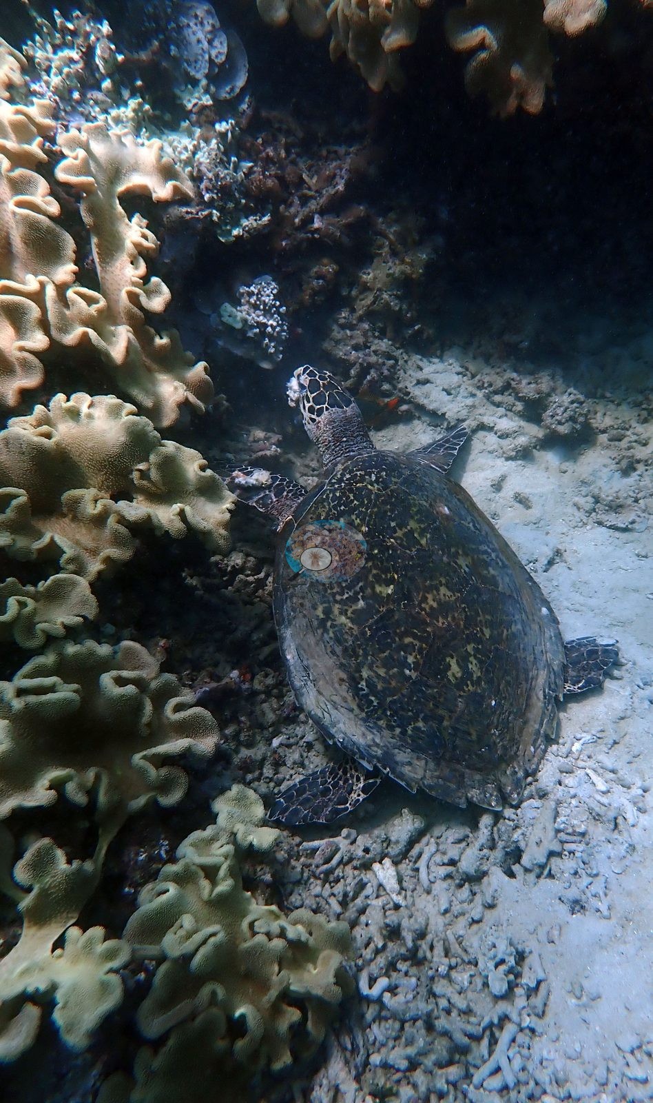
Other life. The headline is a genuinely enormous school of bluestripe snapper (Lutjanus kasmira) -- seven frames of it, filling the frame edge to edge in some and standing off the reef as a solid yellow wall in others. Two further schools of deep-red crescent-tail bigeye-type fish hang over the slope, and single soldierfish and red squirrelfish sit in the reef matrix. Also present: yellow-and-blue fusiliers, damselfish, and anthias over the coral, a large octopus tucked into a rubble den beside a red sponge (photographed four times, from four angles), a big giant clam (Tridacna) with a purple-brown mantle beaded in pearly white, set into a brain coral pavement, and a hawksbill turtle resting on a rubble floor beneath a drape of ruffled cream-olive leather soft corals (Sarcophyton/Lobophytum-type) -- a distinctly soft-coral-dominated overhang, quite unlike the hard coral ridges above it (e.g., Image 3, Image 4).
Comparisons with other data
No independent survey was made at this exact site; the nearest ones are listed in the table below.
Dive record
Dived 21 Mar 2024 at about 8 m on the outer side of Kisite Marine National Park, during the 2024 Western Indian Ocean mass bleaching event; in-water temperature 31.6°C. Surveys were run with REEFolution.
Other notes
This account is written from the site's full photographic record -- all 87 frames, not the four published to the map.
CV model comparison
| Method | Hard-coral cover (%) |
|---|---|
| Manual (published) | 36.6 |
| CoralNet | 36.0 |
| In-house DINOv3 | 42.6 |
| CoralSCOP unedited | 17.3 |
Independent surveys nearby
| Agency / program | Year(s) | Stations / distance | Link |
|---|---|---|---|
| Global bleaching + environmental database | 2016 | 2 stations, 0.20–0.47 km | Records ↓ |
| Kenyan reef survey compilation (source not identified) | — | 3 stations, 1.02–1.79 km | Records ↓ |
| McClanahan et al. (1996) | 1996 | 1 station, 1.48 km | Records ↓ |
| McClanahan et al. (2007) | 1998 | 1 station, 1.60 km | Records ↓ |
| REEFolution Foundation | 2013–2019 | 6 stations, 0.43–3.35 km | Records ↓ |
| WCS Kenya / WCS Tanzania via MERMAID | 2020 | 1 station, 2.41 km | Records ↓ |
| WCS Kenya via MERMAID | 2009–2016 | 7 stations, 0.30–3.30 km | Records ↓ |
 Dr. Coral (CRD)Year-average (no detectable trend)
Within 5 km, 17 independent survey stations recorded hard coral cover in 95 records between 1996 and 2020. Of the 5 stations surveyed in more than one year, 1 declined, 2 increased, and 2 changed by less than 5 percentage points between their first and latest surveys. The longest record, Kisite Edge 2 (REEFolution Foundation, 2.09 km away), went from 21% in 2013 to 15% in 2017. The most recent nearby survey is from 2020, so these values predate recent heat stress. This site's own estimate (37%) sits within the range of these surveys (0.0–56%); the methods differ, so the comparison is context, not a like-for-like test. 3 further rows in the table have no survey date, so they are listed but not part of this summary.
Collected by other programs using different methods (MERMAID is a data platform: each MERMAID row names the organization that did the survey, and its method is in the row's hover text), so these are context for the figures above, not a like-for-like comparison. Where a station was surveyed more than once the range is shown. Station names are not dive-site names.
Show all 21 independent survey records
| Agency | Site / location | Date | Hard coral cover (%) | Distance | Link |
|---|---|---|---|---|---|
| McClanahan et al. (1996) | Kisite Island | 1996 | 24% (3 surveys) | 1.48 km | HeatCRD database |
| McClanahan et al. (2007) | Kisite, Kenya (KN) | post-1998 | 10% | 1.60 km | — |
| McClanahan et al. (2007) | Kisite, Kenya (KN) | pre-1998 | 22% | 1.60 km | — |
| WCS Kenya via MERMAID | Kisite (mean of 2 surveys, 2008–2009) | 2009 | 42% (4 images) | 1.05 km | Darling E. 2018. Kenya CRCP legacy. MERMAID |
| WCS Kenya via MERMAID | Kisite South of Site 1 | 2010 | 56% (2 images) | 1.60 km | Darling E. 2018. Kenya CRCP legacy. MERMAID |
| WCS Kenya via MERMAID | Kisite Edge 1 | 2013 | 42% (2 images) | 0.30 km | Darling E. 2018. Kenya CRCP legacy. MERMAID |
| REEFolution Foundation | Kisite Edge 2 | 2013–2017 | 15–21% (2 surveys) | 2.09 km | 2023. REEFolution Kenya. MERMAID |
| WCS Kenya via MERMAID | Kisite 2 (mean of 2 surveys, 2012–2015) | 2015 | 48% (4 images) | 1.65 km | Darling E. 2018. Kenya CRCP legacy. MERMAID |
| WCS Kenya via MERMAID | Kisite corner | 2016 | 50% (2 images) | 0.30 km | Darling E. 2018. Kenya CRCP legacy. MERMAID |
| WCS Kenya via MERMAID | Kisite 1 (mean of 3 surveys, 2012–2016) | 2016 | 46% (6 images) | 1.05 km | Darling E. 2018. Kenya CRCP legacy. MERMAID |
| WCS Kenya via MERMAID | Mpunguti | 2016 | 32% (3 images) | 3.30 km | Darling E. 2018. Kenya CRCP legacy. MERMAID |
| Global bleaching + environmental database | Kisite corner | 2016-04-18 | 50% | 0.20 km | — |
| REEFolution Foundation | Outer Kisite | 2017–2019 | 39–53% (13 surveys) | 0.43 km | 2023. REEFolution Kenya. MERMAID |
| REEFolution Foundation | Kisite 2 | 2017–2018 | 29–48% (3 surveys) | 1.65 km | 2023. REEFolution Kenya. MERMAID |
| REEFolution Foundation | Dolphin Point | 2017–2019 | 20–42% (14 surveys) | 3.26 km | 2023. REEFolution Kenya. MERMAID |
| REEFolution Foundation | Lower Mpunguti | 2017–2019 | 0.0–8.0% (15 surveys) | 3.35 km | 2023. REEFolution Kenya. MERMAID |
| REEFolution Foundation | Lower Mpunguti (mean of 15 surveys, 2017–2019) | 2019 | 7.1% (15 surveys) | 3.35 km | 2023. REEFolution Kenya. MERMAID |
| WCS Kenya / WCS Tanzania via MERMAID | Mkwiro | 2020 | 29% (3 surveys) | 2.41 km | Darling E, Mensa J, O'Leary J, Schwarz A. 2020. BAF 1 - 2020. MERMAID |
| Kenyan reef survey compilation (source not identified) | Kisite Deep (site code S_KD’14), South zone | — | 12% | 1.02 km | — |
| Kenyan reef survey compilation (source not identified) | Kisite Seaward (site code S_KS’14), South zone | — | 16% | 1.05 km | — |
| Kenyan reef survey compilation (source not identified) | Kisite Leeward (site code S_KL’14), South zone | — | 12% | 1.79 km | — |
Data & links
- CoralNet image repository for this region ↗
- HeatCRD database ↗
- (reference) ↗
- Photo portfolio ↗
- Coral Reef Diagnostics page for this area ↗
All images from Coral Reef Diagnostics. Data are from Coral Reef Diagnostics and the organizations named in the data-sources table above.
© Coral Reef Diagnostics.
References
- McClanahan TR, Kamukuru AT, Muthiga NA, Yebio MG, Obura D (1996). Effect of Sea Urchin Reductions on Algae, Coral, and Fish Populations. Conservation Biology 10:136-154. DOI
- Mayfield AB (2025). A Citizen Science Approach for Documenting Mass Coral Bleaching in the Western Indian Ocean. Environments 12:276. PDF
- McClanahan TR, Ateweberhan M, Muhando CA, Maina J, Mohammed MS (2007). EFFECTS OF CLIMATE AND SEAWATER TEMPERATURE VARIATION ON CORAL BLEACHING AND MORTALITY. Ecological Monographs 77:503-525. DOI