
Kenya - MMP snorkel site (Mombasa) snorkel
Part of the regional summary: Kenya
More info
Kenya (NOAA CRW virtual station) · East African Coral Coast ecoregion mean=4.1°C-heating weeksThis shallow Mombasa Marine Park snorkel site is a back-reef field of Porites bommies substantially draped in fleshy brown algae, and it suffered the most severe bleaching of any Mombasa site reviewed here - 89.9% of hard coral tissue, well above the 77.1% Kenya-wide average - leaving whole frames of chalk-white and cream domes with only scattered pigmented holdouts, including a few strikingly unbleached deep-purple Acropora colonies. Two crown-of-thorns starfish were photographed on one tabular Acropora, though not repeated elsewhere. Published cover was 40%, more than double a 2022 reading nearby (19.5%).
Eneo la kuogelea kwa mrija lenye kina kifupi sana linalotawaliwa na Porites ndani ya Hifadhi ya Bahari ya Mombasa, chini ya tandiko zito la mwani, na ndilo eneo lililopauka vibaya zaidi katika utafiti huu kwa asilimia 89.9. Nyota mbili hadi tatu za bahari zenye miiba zinaonekana juu ya Acropora moja yenye umbo la meza, rekodi mpya kwa eneo hili.
Tafsiri ya muhtasari huu kwa AI; Kiingereza ndicho kinachotumika rasmi. Translated from the site’s shorter map summary.
Seventeen independent survey stations shown with the program’s logo — click one to see how far it is from this site.
Two other CRD dive sites within 5 km shown in orange — click a marker to open its page.
3 of these 4 photographs are shown beside the text that discusses them under "Site description" below.
Site description
Setting
Surface light, wave shimmer, and a snorkeler's fins at the surface appear in the wide frames, confirming very shallow water throughout; visibility is moderate, green-tinged, and plankton-laden, with the far bommies fading into haze.
General benthic features
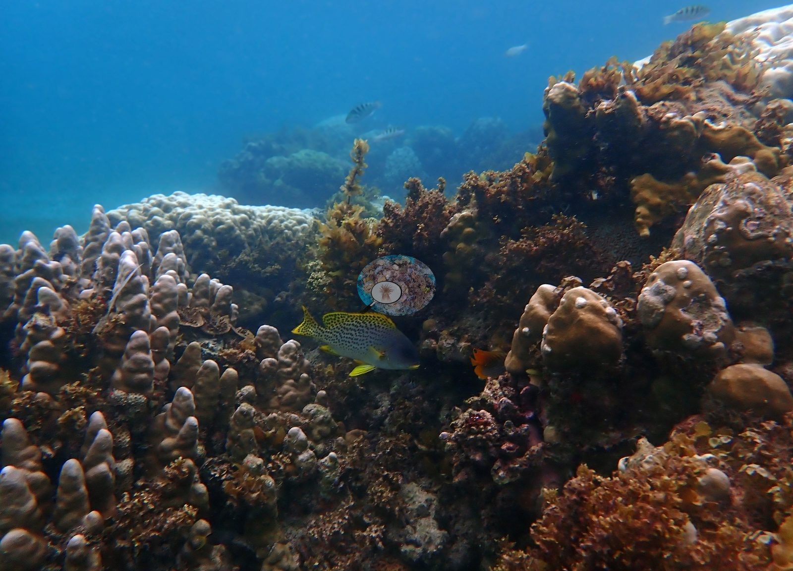
Habitat. The full set confirms the site as a shallow back-reef bommie field: coalescing knobby, lobate, and columnar mounds of Porites type, a meter or so of relief, separated by floors of coarse sand, rubble, and low pavement. Frame after frame is the same architecture -- dome beside dome, sand between. What the four published frames understated is the algae. Roughly a third of the set shows a dense fleshy canopy, brown, rust-red, and olive, draping whole bommie flanks and crests and in places burying the substratum between colonies (the frame Anderson himself named algal-choked is representative, not exceptional) (e.g., Image 1).
This is a defining feature of the site, not incidental turf. Community. Massive and knobby Porites dominate overwhelmingly, in every size from cobble-scale lobes to domes two meters across, along with columnar and finger-form Porites. But the earlier statement that there is essentially no branching framework here does not survive the full set. Tabular and corymbose Acropora recur throughout -- a meter-wide table growing off a bommie flank, several dinner-plate corymbose colonies wedged between Porites lobes, and two large bushy, finely branched Acropora-type colonies standing free on sand. Digitate and columnar corals in pale lilac, small encrusting and plating colonies (Montipora type, one distinctly green), and a scatter of cerioid massives fill in. Branching coral is subordinate to Porites but it is genuinely present and structurally conspicuous. A pink encrusting sponge or coralline and a tan barrel-form sponge occupy interstitial rock; a red whip-like organism rises from an algae-covered mound.
Coral cover
Coral cover 40% -- and 89.9% of hard coral tissue bleached (March-April 2024). Measured from 54 white-balanced photographs taken at this site during the 2024 Western Indian Ocean mass bleaching event and point-annotated in CoralNet, published in Mayfield, A.B. (2025) A Citizen Science Approach for Documenting Mass Coral Bleaching in the Western Indian Ocean. Environments 12(8):276. doi:10.3390/environments12080276. This is a published diver-photograph point-annotation value, not a computer vision estimate, and it is not recomputed here. Across the 20 Kenyan sites the mean was 30% coral cover and 77.1% of tissue bleached.
Stressors
Condition. Bleaching is severe and site-wide, entirely consistent with the published 89.9%. Whole wide frames read as fields of chalk-white, cream, and wan mint domes with only occasional pigmented colonies among them (e.g., Image 4).
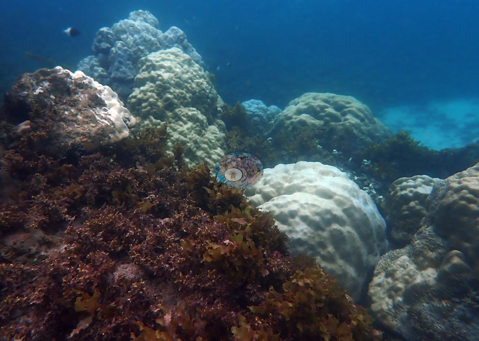
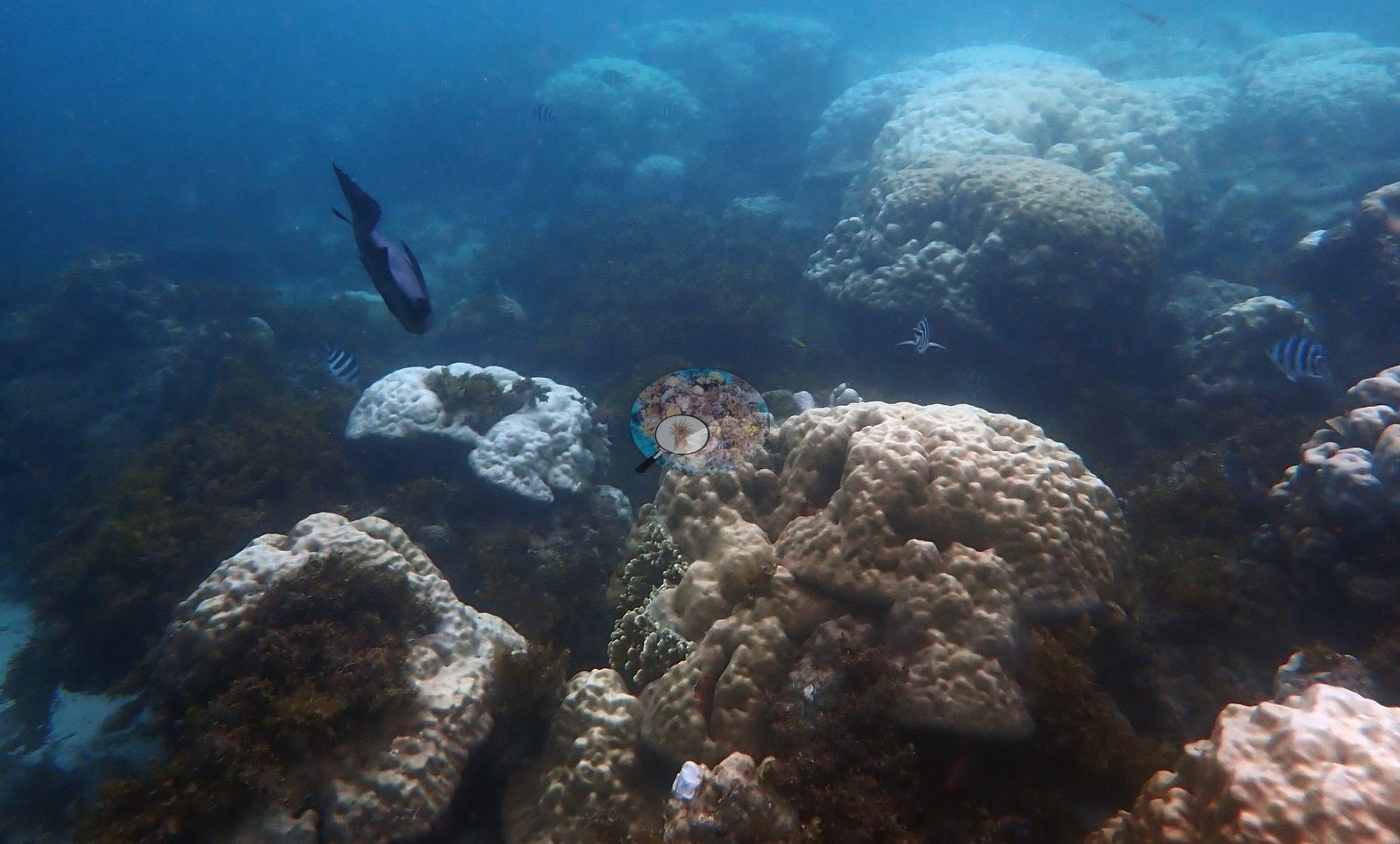
Because these frames are color-adjusted, the strongest evidence is not absolute color but within-frame contrast and structure: one cream Porites dome retains a single discrete brown pigment patch on an otherwise uniformly whitened surface; several frames set fully pigmented ochre, tan, and orange-brown colonies immediately beside stark white ones under the same exposure; and the bleached surfaces show skeletal corallite texture reading straight through the tissue. Two large bushy branching colonies are bleached to a uniform white-lilac from base to branch tip. The pattern is a colony-by-colony mosaic rather than a total whiteout. Fully pigmented holdouts are more numerous than the published four frames suggested. At least four separate deep violet-purple corymbose Acropora colonies appear across the set, each sitting unbleached in an otherwise chalk-white Porites pavement -- so the vivid purple colony is a recurring feature of this reef, not a one-off (e.g., Image 2).
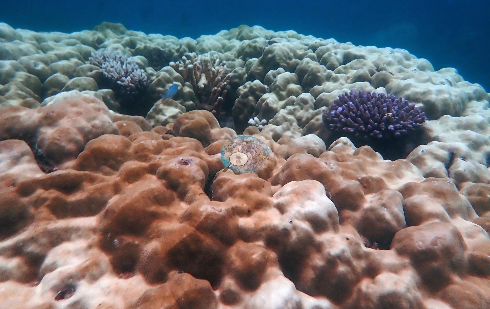
Several large Porites domes hold full orange-brown or ochre pigment, and a fully pigmented tan tabular Acropora sheltering a cloud of black-and-white humbug damselfish appears in two separate frames, confirming a note that had previously been questioned. Crown-of-thorns. One frame is a close-up of a large pale, mottled tabular Acropora with at least two crown-of-thorns seastars on and beside it -- purple-red bodies with long white-tipped spines, unmistakable at this magnification. This is the only frame in which they appear, and no crown-of-thorns are visible anywhere else in the set, so the photographs do not support an outbreak. The plate's pale mottling could be bleaching, feeding scars, or both; the frame does not separate them. The near-total whitening across the full 52-frame set is entirely consistent with that 89.9%. Typical recent thermal stress: mean annual maximum of 4.1 degree heating weeks (2021-2025, NOAA CRW; East African Coral Coast ecoregion). Also on record for this site: Nearly every massive coral was stark white or wan beige; the one striking holdout was a single staghorn thicket that stayed a defiant ochre, sheltering a cloud of humbug dascyllus. Seawater here measured 32.5°C during the survey (the Kenya survey-wide mean of 32.0°C matched the 1998 event), and NOAA recorded a peak of 13.5 degree-heating weeks on 18 April 2024, the highest for Kenya since records began in 1985. In situ temperatures ran 1.3°C above NOAA's estimates, so the true heat stress was likely nearer 22 DHWs.
Fish and other fauna
Other life. Sergeant majors are everywhere over the bleached mounds. Humbug damselfish in the pigmented Acropora tables, a blackspotted sweetlips along a bommie flank, a dark surgeonfish over the crest, a small orange wrasse in the bushy branching colonies, and two frames of a large school of yellow-striped, yellow-tailed fish (goatfish- or snapper-type) drifting over open sand off the reef edge.
Comparisons with other data
No independent survey was made at this exact site; the nearest ones are listed in the table below.
Dive record
Snorkeled 14 Mar 2024 at 1-3 m inside Mombasa Marine Park, during the 2024 Western Indian Ocean mass bleaching event. Surveys were run with Tropical Diving Kenya.
Other notes
This account replaces a four-frame pass: all 52 photographs from the site's edited set were opened and read across 5 contact sheets.
CV model comparison
| Method | Hard-coral cover (%) |
|---|---|
| Manual (published) | 39.6 |
| CoralNet | 39.6 |
| In-house DINOv3 | 54.2 |
| CoralSCOP unedited | 23.3 |
Independent surveys nearby
| Agency / program | Year(s) | Stations / distance | Link |
|---|---|---|---|
| Global bleaching + environmental database | 2016 | 4 stations, 0.53–0.55 km | Records ↓ |
| Mangubhai et al. (2007) | 2003 | 1 station, 2.11 km | Records ↓ |
| McClanahan et al. (1996) | 1994 | 1 station, 3.90 km | Records ↓ |
| McClanahan et al. 2016 | 2016 | 1 station, 2.91 km | Records ↓ |
| WCS Kenya via MERMAID | 2009–2022 | 14 stations, 0.52–3.42 km | Records ↓ |
 Dr. Coral (CRD)Year-average (no detectable trend)
Within 5 km, 21 independent survey stations recorded hard coral cover in 72 records between 1994 and 2022. Of the 1 station surveyed in more than one year, 1 changed by less than 5 percentage points between their first and latest surveys. The longest record, Mombasa (WCS Kenya via MERMAID, 0.86 km away), went from 20% in 2013 to 20% in 2022. One survey since 2021 recorded 20%. This site's own estimate (40%) sits 20.1 points above the recent value (20%); the methods differ, so the comparison is context, not a like-for-like test.
Collected by other programs using different methods (MERMAID is a data platform: each MERMAID row names the organization that did the survey, and its method is in the row's hover text), so these are context for the figures above, not a like-for-like comparison. Where a station was surveyed more than once the range is shown. Station names are not dive-site names.
Show all 21 independent survey records
| Agency | Site / location | Date | Hard coral cover (%) | Distance | Link |
|---|---|---|---|---|---|
| McClanahan et al. (1996) | — | 1994 | 27% | 3.90 km | HeatCRD database |
| Mangubhai et al. (2007) | Coral Gardens | 2003 | 22% | 2.11 km | HeatCRD database |
| WCS Kenya via MERMAID | Mombasa Starfish | 2009 | 24% (2 images) | 0.86 km | Darling E. 2018. Kenya CRCP legacy. MERMAID |
| WCS Kenya via MERMAID | Mombasa Braincoral | 2009 | 14% (6 images) | 3.07 km | Darling E. 2018. Kenya CRCP legacy. MERMAID |
| WCS Kenya via MERMAID | Taa | 2009 | 14% (2 images) | 3.10 km | Darling E. 2018. Kenya CRCP legacy. MERMAID |
| WCS Kenya via MERMAID | Shark Point 2 | 2009 | 9.7% (6 images) | 3.42 km | Darling E. 2018. Kenya CRCP legacy. MERMAID |
| WCS Kenya via MERMAID | Bamburi Wreck | 2010 | 10% (2 images) | 0.94 km | Darling E. 2018. Kenya CRCP legacy. MERMAID |
| WCS Kenya via MERMAID | Kasa_Mombasa (mean of 4 surveys, 2009–2010) | 2010 | 19% (12 images) | 1.68 km | Darling E. 2018. Kenya CRCP legacy. MERMAID |
| WCS Kenya via MERMAID | Mombasa | 2013–2022 | 20% (4 images) | 0.86 km | Darling E. 2018. Kenya CRCP legacy. MERMAID; Darling E, Kosgei J, McClanahan T, Muthiga N, Oddenyo R. 2022. Kenya-Marine Monitoring_2022. MERMAID |
| WCS Kenya via MERMAID | Mombasa 3 | 2016 | 15% (4 images) | 0.52 km | Darling E. 2018. Kenya CRCP legacy. MERMAID |
| WCS Kenya via MERMAID | Mombasa 2 | 2016 | 18% (4 images) | 0.54 km | Darling E. 2018. Kenya CRCP legacy. MERMAID |
| WCS Kenya via MERMAID | Mombasa Coral Gardens 3 | 2016 | 23% (2 images) | 0.86 km | Darling E. 2018. Kenya CRCP legacy. MERMAID |
| WCS Kenya via MERMAID | Mombasa Coral Gardens 2 | 2016 | 23% (2 images) | 0.86 km | Darling E. 2018. Kenya CRCP legacy. MERMAID |
| WCS Kenya via MERMAID | Mombasa Mushroom (mean of 2 surveys, 2009–2016) | 2016 | 23% (4 images) | 2.29 km | Darling E. 2018. Kenya CRCP legacy. MERMAID |
| McClanahan et al. 2016 | RasIwatine (Kenya) | 2016 | 22% | 2.91 km | — |
| Global bleaching + environmental database | Mombasa 3 | 2016-04-10 | 15% | 0.53 km | — |
| Global bleaching + environmental database | Mombasa 2 | 2016-04-10 | 20% | 0.55 km | — |
| Global bleaching + environmental database | Coral gardens 3 (starfish) | 2016-05-12 | 14% | 0.53 km | — |
| Global bleaching + environmental database | Coral gardens 2 | 2016-05-12 | 15% | 0.55 km | — |
| WCS Kenya via MERMAID | Mombasa Coral Gardens (mean of 6 surveys, 2009–2017) | 2017 | 21% (12 images) | 0.86 km | Darling E. 2018. Kenya CRCP legacy. MERMAID |
| WCS Kenya via MERMAID | Mombasa Green turtle | 2017 | 54% (3 images) | 1.68 km | Darling E. 2018. Kenya CRCP legacy. MERMAID |
Data & links
- CoralNet image repository for this region ↗
- HeatCRD database ↗
- (reference) ↗
- Photo portfolio ↗
- Coral Reef Diagnostics page for this area ↗
All images from Coral Reef Diagnostics. Data are from Coral Reef Diagnostics and the organizations named in the data-sources table above.
© Coral Reef Diagnostics.
References
- McClanahan TR, Kamukuru AT, Muthiga NA, Yebio MG, Obura D (1996). Effect of Sea Urchin Reductions on Algae, Coral, and Fish Populations. Conservation Biology 10:136-154. DOI
- Mangubhai S, Harrison P, Obura D (2007). Patterns of coral larval settlement on lagoon reefs in the Mombasa Marine National Park and Reserve, Kenya. Marine Ecology Progress Series 348:149-159. PDF
- Mayfield AB (2025). A Citizen Science Approach for Documenting Mass Coral Bleaching in the Western Indian Ocean. Environments 12:276. PDF