
Kenya - Lower Mpunguti-site 1 (Kisite National Park)

Part of the regional summary: Kenya
More info
Kenya (NOAA CRW virtual station) · East African Coral Coast ecoregion mean=4.1°C-heating weeksLower Mpunguti-site 1 has the lowest coral cover of the Kisite-Mpunguti pins (18.1%) because coral here sits as isolated colonies embedded in a thick carpet of fleshy macroalgae rather than as a continuous framework. Branching and massive corals took the worst bleaching (79.7% of tissue overall), while golden-olive Turbinaria bowl corals were the clear survivors, holding full pigment throughout; three sea anemones with tentacles blanched snow-white above deep crimson columns were also documented here, alongside unbleached giant clams and a blue-spotted ribbontail ray.
Eneo lenye kina kifupi lililosongwa na mwani nje ya Lower Mpunguti, na lenye kiwango cha chini kabisa cha matumbawe kati ya alama nne za Kisite, lililopigwa picha katika mkondo mfupi wa dakika kumi na tano. Matumbawe ya kikombe ya Turbinaria yalikuwa kundi kuu lililonusurika, na anemone tatu zimesimama zikiwa nyeupe juu ya nguzo nyekundu-damu.
Tafsiri ya muhtasari huu kwa AI; Kiingereza ndicho kinachotumika rasmi. Translated from the site’s shorter map summary.
23 independent survey stations shown with the program’s logo — click one to see how far it is from this site.
Six other CRD dive sites within 5 km shown in orange — click a marker to open its page.
Site description
General benthic features
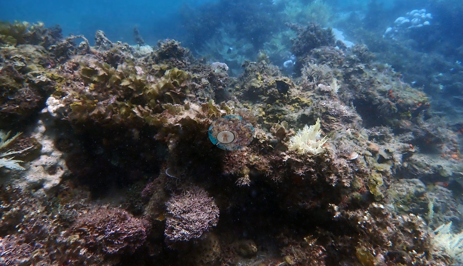
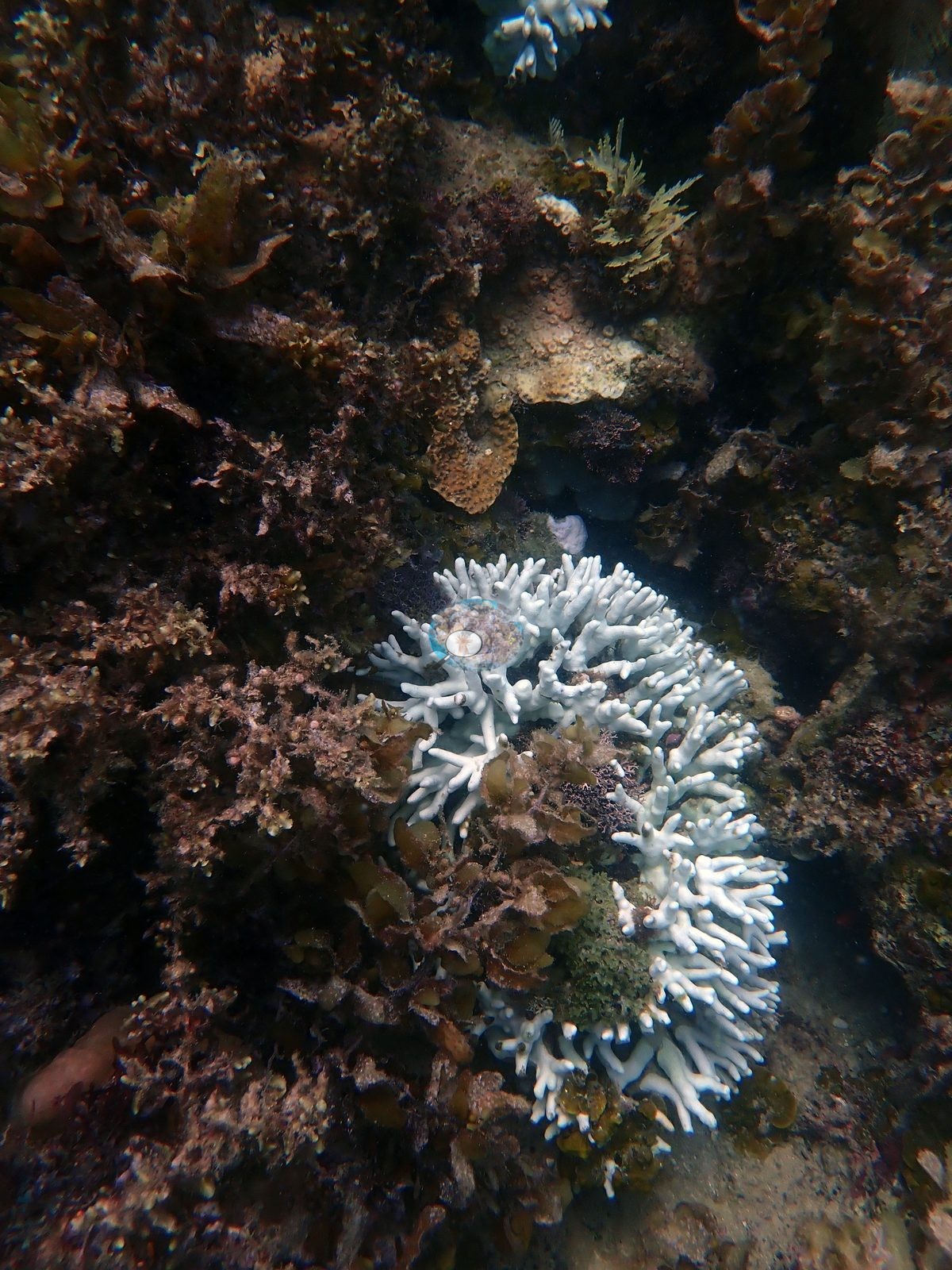
The loudest signal in the set is still algae, not bleaching, and the full run makes the case far more strongly than the four published frames did. Fleshy macroalgae -- rust-red and olive foliose fronds, brown Sargassum- and Dictyota-like blades, and green Halimeda-type tufts -- blanket the hardground in nearly every wide frame. Anderson named two frames for it outright: one is a reef mound almost wholly upholstered in weed with only two white coral heads showing through, and the other is a single bleached branching colony ringed and half-buried by canopy (e.g., Image 3, Image 4).
Coral here is not a framework; it is isolated colonies set into an algal carpet, which reads as the physical expression of the site's 18% cover -- the lowest of the Kisite-Mpunguti pins.
Coral cover
Coral cover 18% -- and 79.7% of hard coral tissue bleached (March-April 2024). Measured from 36 white-balanced photographs taken at this site during the 2024 Western Indian Ocean mass bleaching event and point-annotated in CoralNet, published in Mayfield, A.B. (2025) A Citizen Science Approach for Documenting Mass Coral Bleaching in the Western Indian Ocean. Environments 12(8):276. doi:10.3390/environments12080276. This is a published diver-photograph point-annotation value, not a computer vision estimate. Across the 20 Kenyan sites the mean was 30% coral cover and 77.1% of tissue bleached; this was among the sparsest sites of the survey.
Stressors
Bleaching is extensive but not uniform, and it sorts by growth form. Branching and corymbose Acropora are the worst hit: stark bone-white thickets in six frames (one a broad fine-branched stand gone entirely white, with a second white colony below it), with a few colonies tinged pale lilac-blue rather than pure white in two others. Massive and domed colonies are close behind: chalk-white domes with dark fissures in two frames, a bone-white knobby columnar colony standing proud of the reef with a crinoid at its base in another, and a cluster of white massives over sand in a fourth (e.g., Image 1).
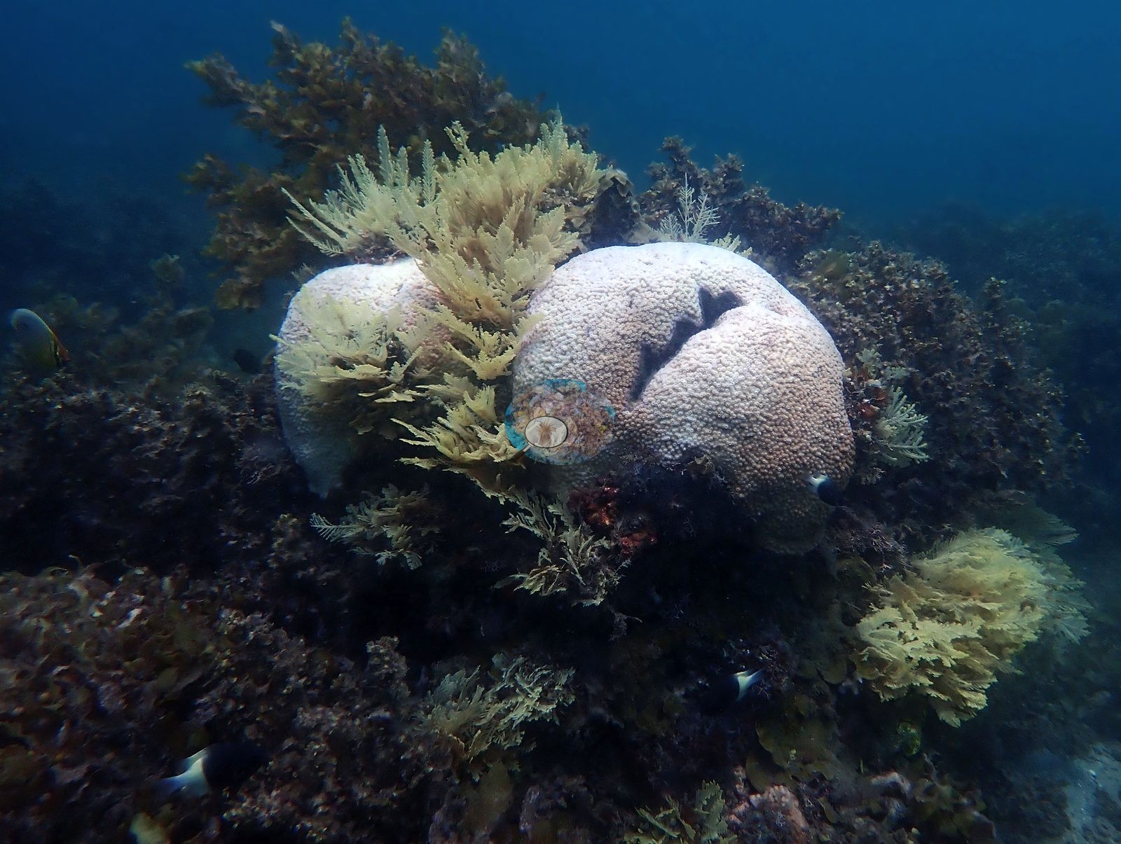
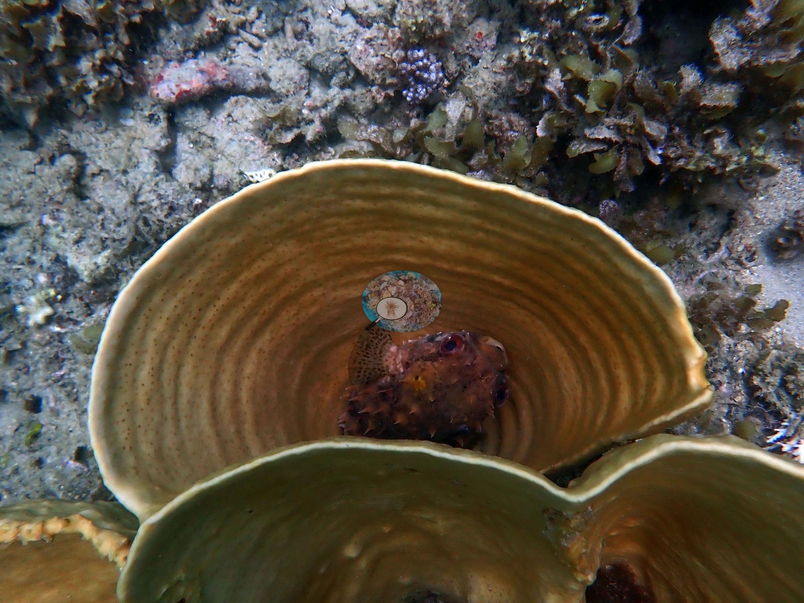
Anderson's own named frames add two more: one is a pale cream Astreopora dome set in macroalgae, and the other is a white-to-pale-gray digitate finger Porites colony ringed by weed. One frame is a mauve-pink encrusting mass -- the intermediate paling tone rather than full white -- and another is a pale blue-gray meandroid brain coral with its valleys still sharply defined, emerging from a thicket of brown fronds. The last frame of the dive is a large smooth-lobed chalk-white mass on the sand, most consistent with a bleached leather soft coral (Sarcophyton-type); a pale sponge cannot be excluded from the frame alone. Against that, the foliose cup and plate corals are the clear survivors, and the full set turns what the earlier pass called a single refugium into a repeated pattern. Turbinaria-type bowls appear fully pigmented golden-olive to tan in four frames, including a top-down stack of tiered bowls with fine concentric growth lines and a large healthy cabbage-form colony -- and one of them confirms what the earlier description had only inferred, showing a small pufferfish tucked down inside the bowl (e.g., Image 2).
Two frames are broad tan-brown foliose plates whose only whitening is a narrow band along the growing margin, which on these color-adjusted frames could as easily be the normal pale growth edge as a bleaching front. The one foliose colony that does look genuinely bleached is a large stacked whorl-form plate gone uniformly pale cream on an algal ridge. One frame places a bleached white Acropora directly against a large tan barrel sponge on the rubble. Typical recent thermal stress: mean annual maximum of 4.1 degree heating weeks (2021-2025, NOAA CRW; East African Coral Coast ecoregion). Seawater here measured 31.9°C during the survey (the Kenya survey-wide mean of 32.0°C matched the 1998 event), and NOAA recorded a peak of 13.5 degree-heating weeks on 18 April 2024, the highest for Kenya since records began in 1985. In situ temperatures ran 1.3 degrees C above NOAA's estimates, so the true heat stress was likely nearer 22 DHWs. No crown-of-thorns starfish (COTS) or other corallivores evident.
Fish and other fauna
The fauna in the wider set is richer than the published subset showed, and several of it settles earlier open questions. One frame, which Anderson himself labeled a bleached anemone, shows three magnificent sea anemones with tentacles blanched snow-white above deep crimson-magenta columns, packed together on the rock; this is the frame the site record had described for years without any published image to stand behind it. Another puts a blue-spotted ribbontail ray under a ledge on clean sand beside pale coral heads. One frame shows two giant clams (Tridacna) side by side with fluted mantles still patterned brown-gold and olive, no whitening, among crinoids and orange encrusting sponge. Another is a red-and-white striped squirrelfish resting against a bone-white dome, and a third an orange encrusting sponge worked over by small damselfish. Two more frames are views of a pale mauve-white sea cucumber on the sand, and another a sand channel beneath an algal-crusted overhang with almost no coral in it.
Comparisons with other data
No independent survey was made at this exact site; the nearest ones are listed in the table below.
Dive record
Dived 21 Mar 2024 at about 5 m off Lower Mpunguti in Kisite Marine National Park, during the 2024 Western Indian Ocean mass bleaching event. EXIF on the full set dates every frame to 21 March 2024 and brackets the photographic run between 13:20:04 and 13:35:14 -- a tight fifteen-minute sequence of 34 frames, essentially contiguous in camera numbering. Surveys were run with REEFolution.
CV model comparison
More info
The like-for-like row is the recomputed manual, not the published one. ⚠ The CV columns are on the OLD all-30 denominator while the published manual is on the settled rule; on these frames that understates cover by ~3.0 pp. The 50-frame batch is 6.3 pp poorer in cover than the survey average, so the CV columns are subset-distorted as well as denominator-shifted. Round Reef and Uyombo roll up 15 and 16 quadrat codes respectively. CoralSCOP (SAM-based mask-sum), edited photos: n/a — CoralSCOP was never run on Kenya edited copies; owner's ruling 2026-09-17: 'for kenya, it's only on unedited'| Method | Hard-coral cover (%) |
|---|---|
| Manual (published) | 18.1 |
| CoralNet | 17.1 |
| In-house DINOv3 | 37.3 |
| CoralSCOP unedited | 20.5 |
| Claude | 16.7 |
Independent surveys nearby
| Agency / program | Year(s) | Stations / distance | Link |
|---|---|---|---|
| Kenyan reef survey compilation (source not identified) | — | 1 station, 1.62 km | Records ↓ |
| MERMAID project “KenyaBleachingSurveys_2024”* | 2024 | 1 station, 3.49 km | Records ↓ |
| REEFolution Foundation | 2017–2023 | 9 stations, 0.69–4.94 km | Records ↓ |
| WCS Kenya / WCS Tanzania via MERMAID | 2020 | 1 station, 2.09 km | Records ↓ |
| WCS Kenya via MERMAID | 2009–2019 | 12 stations, 1.45–4.94 km | Records ↓ |
 Dr. Coral (CRD)Year-average (no detectable trend)
Within 5 km, 23 independent survey stations recorded hard coral cover in 185 records between 2009 and 2024. Of the 8 stations surveyed in more than one year, 3 declined, 3 increased, and 2 changed by less than 5 percentage points between their first and latest surveys. The longest record, Kikuyu House (REEFolution Foundation, 3.63 km away), went from 32% in 2018 to 23% in 2023. Surveys since 2021 average 34% (range 4.9–66%, n=7). This site's own estimate (18%) sits within the recent range (4.9–66%); the methods differ, so the comparison is context, not a like-for-like test. One further row in the table has no survey date, so it is listed but not part of this summary.
Collected by other programs using different methods (MERMAID is a data platform: each MERMAID row names the organization that did the survey, and its method is in the row's hover text. *Conducted by citizen scientists), so these are context for the figures above, not a like-for-like comparison. Where a station was surveyed more than once the range is shown. Station names are not dive-site names.
Show all 24 independent survey records
| Agency | Site / location | Date | Hard coral cover (%) | Distance | Link |
|---|---|---|---|---|---|
| WCS Kenya via MERMAID | Kisite (mean of 2 surveys, 2008–2009) | 2009 | 42% (4 images) | 4.46 km | Darling E. 2018. Kenya CRCP legacy. MERMAID |
| WCS Kenya via MERMAID | Kisite South of Site 1 | 2010 | 56% (2 images) | 4.32 km | Darling E. 2018. Kenya CRCP legacy. MERMAID |
| WCS Kenya via MERMAID | Waga | 2011 | 25% (2 images) | 4.45 km | Darling E. 2018. Kenya CRCP legacy. MERMAID |
| WCS Kenya via MERMAID | Waga 2 | 2011 | 25% (2 images) | 4.45 km | Darling E. 2018. Kenya CRCP legacy. MERMAID |
| WCS Kenya via MERMAID | Kisite Edge 1 | 2013 | 42% (2 images) | 4.14 km | Darling E. 2018. Kenya CRCP legacy. MERMAID |
| WCS Kenya via MERMAID | Jiwe la kale East | 2014 | 25% (2 images) | 3.43 km | Darling E. 2018. Kenya CRCP legacy. MERMAID |
| WCS Kenya via MERMAID | Kisite 2 (mean of 2 surveys, 2012–2015) | 2015 | 48% (4 images) | 4.94 km | Darling E. 2018. Kenya CRCP legacy. MERMAID |
| WCS Kenya via MERMAID | Mpunguti | 2016 | 32% (3 images) | 1.45 km | Darling E. 2018. Kenya CRCP legacy. MERMAID |
| WCS Kenya via MERMAID | Kisite corner | 2016 | 50% (2 images) | 4.14 km | Darling E. 2018. Kenya CRCP legacy. MERMAID |
| WCS Kenya via MERMAID | Kisite 1 (mean of 3 surveys, 2012–2016) | 2016 | 46% (6 images) | 4.46 km | Darling E. 2018. Kenya CRCP legacy. MERMAID |
| REEFolution Foundation | Lower Mpunguti | 2017–2019 | 0.0–8.0% (15 surveys) | 0.69 km | 2023. REEFolution Kenya. MERMAID |
| REEFolution Foundation | Dolphin Point | 2017–2019 | 20–42% (14 surveys) | 2.36 km | 2023. REEFolution Kenya. MERMAID |
| REEFolution Foundation | Outer Kisite | 2017–2019 | 39–53% (13 surveys) | 4.01 km | 2023. REEFolution Kenya. MERMAID |
| REEFolution Foundation | House Reef Firefly | 2017–2021 | 39–66% (21 surveys) | 4.50 km | 2023. REEFolution Kenya. MERMAID |
| REEFolution Foundation | Kisite 2 | 2017–2018 | 29–48% (3 surveys) | 4.94 km | 2023. REEFolution Kenya. MERMAID |
| REEFolution Foundation | Mkwiro CMA | 2018–2023 | 29–37% (7 surveys) | 3.52 km | 2023. REEFolution Kenya. MERMAID |
| REEFolution Foundation | Kikuyu House | 2018–2023 | 23–32% (24 surveys) | 3.63 km | 2023. REEFolution Kenya. MERMAID |
| REEFolution Foundation | Pilli Pipa Restaurant | 2018–2023 | 4.9–56% (31 surveys) | 4.21 km | 2023. REEFolution Kenya. MERMAID |
| REEFolution Foundation | Lower Mpunguti (mean of 15 surveys, 2017–2019) | 2019 | 7.1% (15 surveys) | 0.69 km | 2023. REEFolution Kenya. MERMAID |
| WCS Kenya via MERMAID | Mji wa Kale 2 (Mkwiro) (mean of 2 surveys, 2015–2019) | 2019 | 22% (4 images) | 3.52 km | Darling E, Kosgei J, McClanahan T, Muthiga N. 2019. Kenya MACMON 2016-17. MERMAID |
| WCS Kenya via MERMAID | Mji wa Kale 1 (Mkwiro) (mean of 2 surveys, 2015–2019) | 2019 | 26% (4 images) | 3.72 km | Darling E, Kosgei J, McClanahan T, Muthiga N. 2019. Kenya MACMON 2016-17. MERMAID |
| WCS Kenya / WCS Tanzania via MERMAID | Mkwiro | 2020 | 29% (3 surveys) | 2.09 km | Darling E, Mensa J, O'Leary J, Schwarz A. 2020. BAF 1 - 2020. MERMAID |
| MERMAID project “KenyaBleachingSurveys_2024”* | Mji wa Kale 1 (Mkwiro) | 2024 | 36% (2 images) | 3.49 km | Kosgei J, Musembi P. 2024. KenyaBleachingSurveys_2024. MERMAID |
| Kenyan reef survey compilation (source not identified) | Upper Mpunguti Leeward (site code S_UPL’14), South zone | — | 12% | 1.62 km | — |
Data & links
- CoralNet image repository for this region ↗
- Photo portfolio ↗
- Coral Reef Diagnostics page for this area ↗
All images from Coral Reef Diagnostics. Data are from Coral Reef Diagnostics and the organizations named in the data-sources table above.
© Coral Reef Diagnostics.