

Atauro - Pinnacle

Part of the regional summary: Timor-Leste
More info
Timor-Leste (NOAA CRW virtual station) · Lesser Sunda ecoregion mean=6.9°C-heating weeksThe deepest of the Atauro dives, to 35.7 m, on a dim, patchy reef dominated by encrusting life rather than a coral carpet: turf-covered framework with scattered Porites heads and plating corals, big finger and tube sponges, and an unusually high density of feather stars.
Twelve independent survey stations shown with the program’s logo — click one to see how far it is from this site.
Seven other CRD dive sites within 5 km shown in orange — click a marker to open its page.
Site description
General benthic features
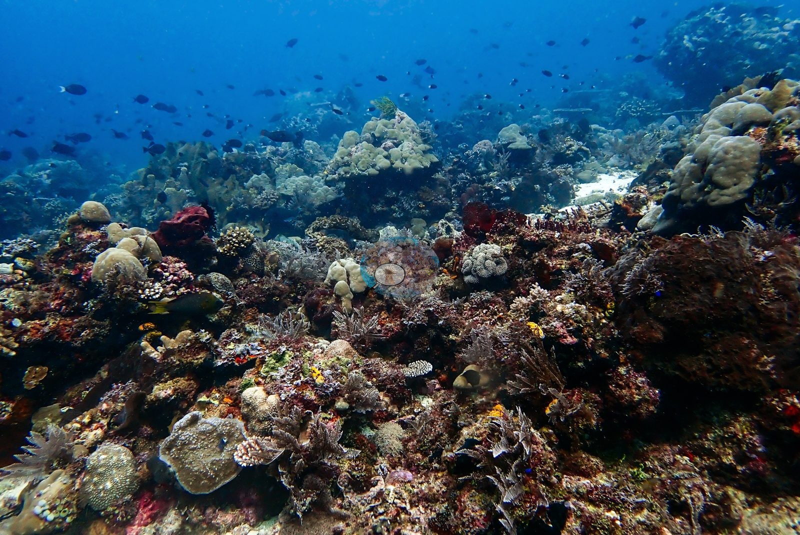
The habitat these four frames show is patchy and encruster-dominated rather than a coral carpet. The widest frame is a reef top of dark maroon algal turf and framework with corals scattered across it: cream-tan massive lobate Porites heads, pale gray plating colonies, small pale corymbose and digitate colonies, a vivid red barrel-like sponge and a maroon sponge, patches of open sand behind, and an unusually high density of feather stars — a dozen or more crinoids across the foreground alone (e.g., Image 1).
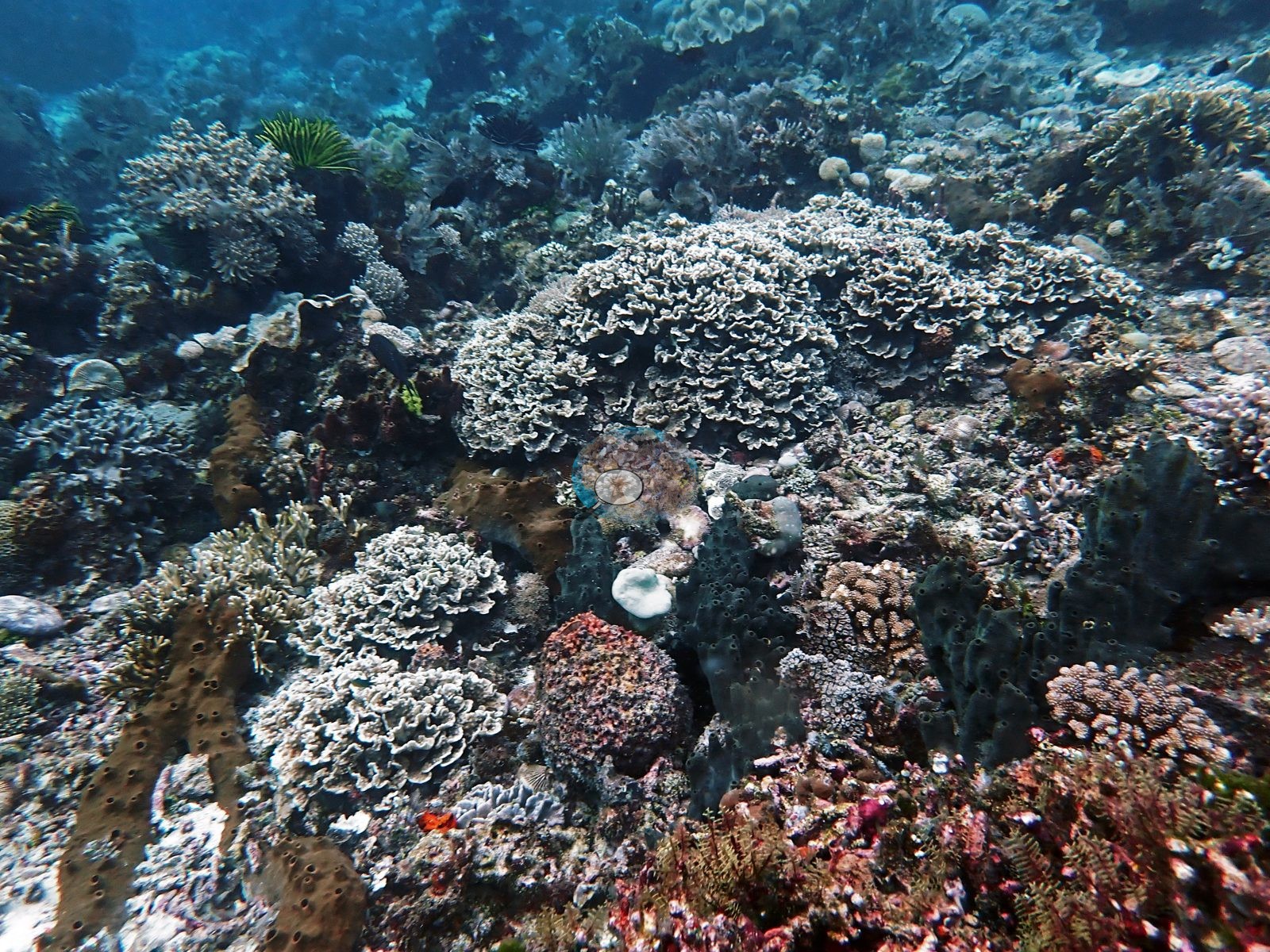
A second wide frame is the sponge-and-foliose face of the site: several large pale-cream tightly convoluted foliose colonies, prominent dark gray finger and tube sponges with open oscula, brown tubular sponges, red, and purple encrusting sponges, pink-mauve encrusting corals, more crinoids, and a single small white patch that could be a bleached nubbin or a chip of dead skeleton — not resolvable from the photograph (e.g., Image 4).
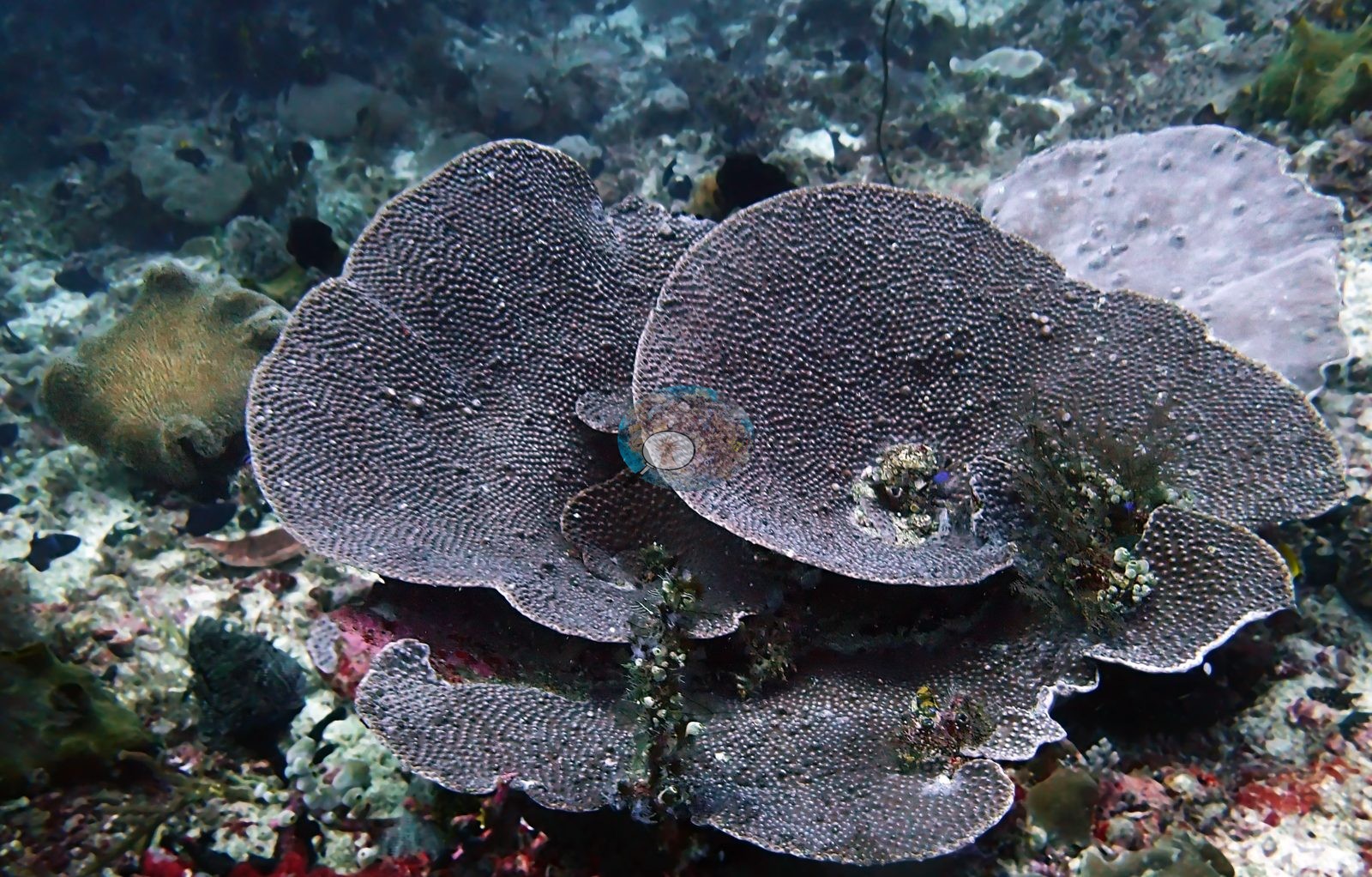
The third frame is a large tiered plating colony in dark purple-gray with a distinctly beaded surface (Montipora-like), stacked in overlapping plates over sediment-dusted rubble, with a smoother lavender plate alongside and small hydroid tufts growing on it (e.g., Image 3).
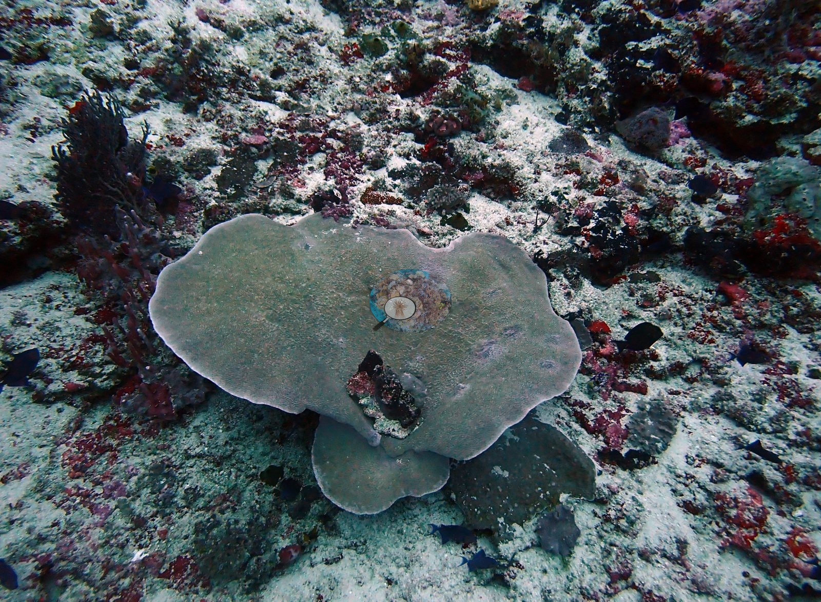
The fourth is the most telling for cover: one solitary gray-green plate colony sitting on open, sediment-veneered hardground crusted with pink and red coralline algae, ringed by small blue damselfishes, with essentially no other living coral in frame (e.g., Image 2).
Coral cover
Coral cover: 20% — a blind Claude computer-vision point count of 53 of Anderson's edited photographs (20 points per photo; water, fish, and obstructions excluded). Other computer-vision methods are listed in the method table. Nothing above is a cover estimate of ours from the photographs.
Stressors
No transect tape, mooring, gear, or other man-made object appears; no disease lesion or predation scar is visible.
Fish and other fauna
Dark chromis hang in the blue, with a yellow-tailed snapper- or grouper-like fish and a small butterflyfish over the reef.
Comparisons with other data
Also on record for this site: That average conceals real local variation: a substantial minority of the reviewed frames show dense, edge-to-edge coral cover — extensive massive Porites stands and branching Acropora thickets fill several frames outright — so "scattered" and "occasional branching growth" undersell the density in those pockets even though most of the site reads as open. Small fishes occur above the substrate, and the site still appears more open on average than Raiketa, Haruine, Inner Reef, or Cabbage Patch in the edited evidence. Paling is more widespread than a single frame: at least three separate colonies show conspicuous whitening across the reviewed selections — a branching soft coral reduced to little more than an olive-green core, a table Acropora with a distinct bleached patch, and a second table Acropora colony rendered pale white outright.
Dive record
Pinnacle was dived on 31 January 2024, in at 08:28 for 46 minutes, 35.7 m maximum and 16.8 m average depth, minimum water temperature 26.7°C (lifetime dive 255) — the deepest of the Atauro dives, and the frames look it: light is dim and blue-green rather than bright.
CV model comparison
More info
DINOv3 and CoralSCOP were run on the same photos and are listed for comparison. Coralscapes v2 and v1 were also run but are not shown: Anderson does not consider Coralscapes reliable for these photos. No diver transect exists for this trip, so agreement between the rows is not accuracy, and as of September 2026 no computer-vision method estimates coral cover accurately on new images; treat every row as indicative.| Method | Hard-coral cover (%) |
|---|---|
| In-house DINOv3 | 26.1 |
| CoralSCOP edited | 38.6 |
| Claude (edited photos) | 19.7 |
Independent surveys nearby
| Agency / program | Year(s) | Stations / distance | Link |
|---|---|---|---|
| Coral Triangle Center (CTC) | 2017 | 2 stations, 2.20–3.02 km | Records ↓ |
| Reef Check | 2004–2017 | 7 stations, 0.38–4.33 km | Records ↓ |
| XL Catlin Seaview Survey | 2014 | 3 stations, 1.18–3.09 km | Records ↓ |
 Dr. Coral (CRD)Year-average (no detectable trend)
Within 5 km, 12 independent survey stations recorded hard coral cover in 29 records between 2004 and 2017. The most recent nearby survey is from 2017, so these values predate recent heat stress. This site's own estimate (20%) sits within the range of these surveys (13–65%); the methods differ, so the comparison is context, not a like-for-like test.
Collected by other programs using different methods (Reef Check uses point-intercept transects; the XL Catlin Seaview Survey uses photo-transects with automated image annotation), so these are context for the figures above, not a like-for-like comparison. Where a station was surveyed more than once the range is shown. Station names are not dive-site names.
Show all 12 independent survey records
| Agency | Site / location | Date | Hard coral cover (%) | Distance | Link |
|---|---|---|---|---|---|
| Reef Check | South of Tanjung Reta | 2004 | 33% (2 surveys) | 0.38 km | — |
| Reef Check | North of Tanjung Reta | 2004 | 44% (2 surveys) | 2.17 km | — |
| Reef Check | South of Barstool | 2004 | 25% (2 surveys) | 4.07 km | — |
| XL Catlin Seaview Survey | transect 30014 | 2014 | 17% | 1.18 km | — |
| XL Catlin Seaview Survey | transect 30013 | 2014 | 13% | 2.45 km | — |
| XL Catlin Seaview Survey | transect 30015 | 2014 | 21% | 3.09 km | — |
| Coral Triangle Center (CTC) | Outer Reef (09) | 2017 | 41% (7 surveys) | 2.20 km | Currier K, Marine P, Welly M. 2017. Atauro Island MPA. MERMAID |
| Reef Check | Haru ina | 2017 | 53% (2 surveys) | 2.26 km | — |
| Coral Triangle Center (CTC) | Beloi (10) | 2017 | 49% (8 surveys) | 3.02 km | Currier K, Marine P, Welly M. 2017. Atauro Island MPA. MERMAID |
| Reef Check | Rai keta tungu | 2017 | 65% | 3.66 km | — |
| Reef Check | Rai keta rala | 2017 | 39% | 4.30 km | — |
| Reef Check | Watu ai | 2017 | 49% | 4.33 km | — |
Data & links
- Site info: Photo gallery ↗
- HeatCRD database ↗
- (reference) ↗
- Photo portfolio ↗
- Coral Reef Diagnostics page for this area ↗
All images from Coral Reef Diagnostics. Data are from Coral Reef Diagnostics and the organizations named in the data-sources table above.
© Coral Reef Diagnostics.