

Atauro - Biqueli Wall

Part of the regional summary: Timor-Leste
More info
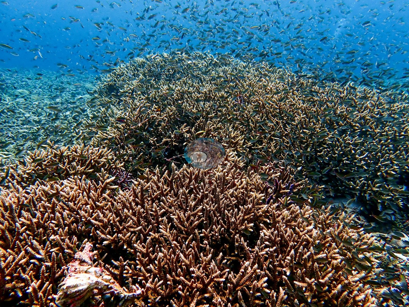
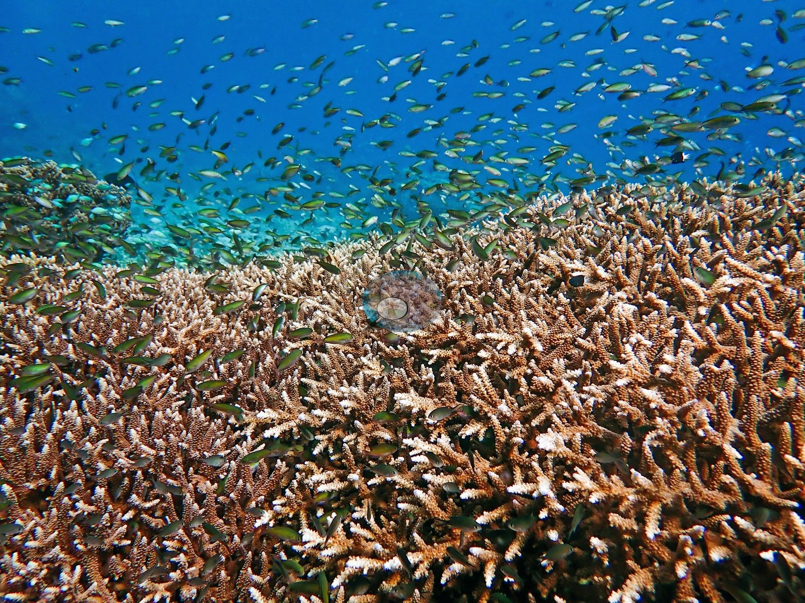
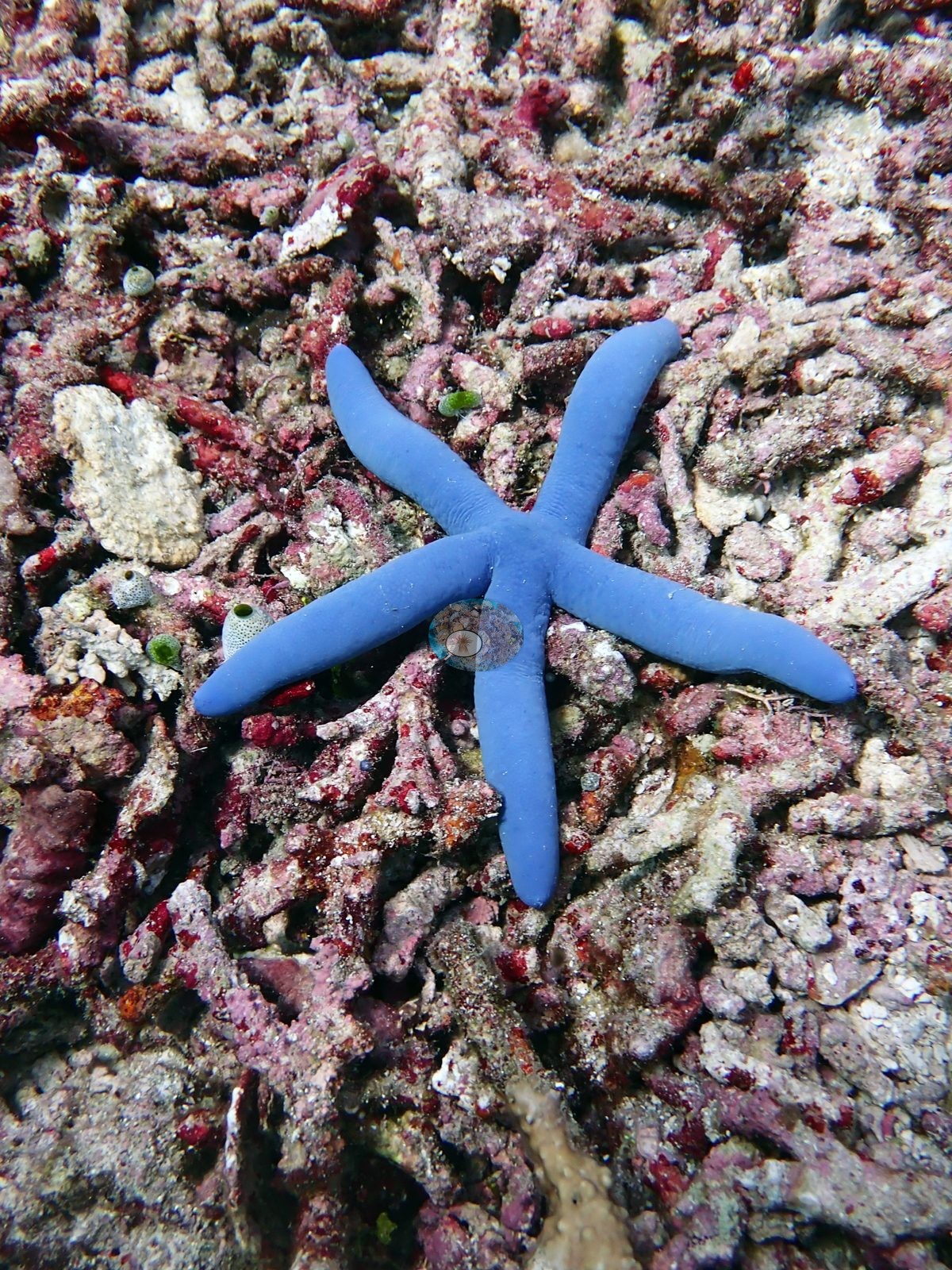
Timor-Leste (NOAA CRW virtual station) · Lesser Sunda ecoregion mean=6.9°C-heating weeksAlthough named for its wall, the surviving photographs from this Atauro dive show the upper terrace: a near-continuous field of tan branching Acropora under hundreds of damselfish and fusiliers. Patches of dead Acropora rubble crusted in pink coralline algae, one with a blue sea star, sit among the living thickets.
Nine independent survey stations shown with the program’s logo — click one to see how far it is from this site.
Three other CRD dive sites within 5 km shown in orange — click a marker to open its page.
Site description
Setting
What the four surviving frames document, however, is the upper terrace rather than the drop-off. Taken together the frames show excellent visibility, high branching-Acropora cover, and exceptional small-fish abundance in the shallows, alongside at least one substantial coralline-bound rubble field.
General benthic features
Frame by frame: the first is a broad wide-angle over a near-continuous field of tan corymbose and digitate Acropora, mound after mound of fine branching growth running to a flat horizon, with an enormous aggregation of small planktivorous fishes — damselfishes and fusilier-like schools numbering in the hundreds — filling the entire water column above it; a single block of pale dead skeleton crusted in pink coralline sits in the near foreground (e.g., Image 1).
The second is the same habitat in better light: wall-to-wall corymbose Acropora with pale branch tips sloping gently into clear blue, again with a dense cloud of dark-green damselfishes hovering over the thicket and hundreds more strung out into the blue (e.g., Image 2).
The third frame is a close view of the other extreme — a blue sea star consistent with Linckia laevigata lying across a consolidated bed of dead Acropora branch rubble entirely encrusted in pink and mauve crustose coralline algae, with red encrusting growth and a few small green ascidians and sponges, and no living coral in the frame at all (e.g., Image 3).
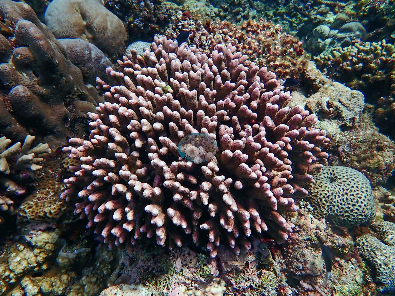
The fourth is a coral-rich pavement at mid relief: a large mauve-pink digitate colony with blunt, pale-tipped fingers dominates the center, flanked by dark brown massive lobate Porites, tan honeycomb-textured faviid brain corals, pale branching growth, a black feather star tucked into a crevice, and a few dark damselfishes (e.g., Image 4).
Coral cover
Coral cover: 27% — a blind Claude computer-vision point count of 147 of Anderson's edited photographs (20 points per photo; water, fish, and obstructions excluded). Other computer-vision methods are listed in the method table.
Stressors
No bleaching, disease lesion, predation scar, transect tape, mooring, or other man-made object appears in any frame.
Comparisons with other data
Also on record for this site: Sand, pale framework, and rubble channels separate the denser patches. Black feather stars (crinoids) recur constantly on bommie tops throughout the sequence, and barrel, tube, and encrusting sponges are a regular presence, though neither is a dominant visual feature. Small reef fishes occur above the coral, while individual bommies support several growth forms within a compact area. Because the reviewed images do not document the full drop-off, this is an account of the photographed upper reef at Biqueli Wall, not a complete characterization of the wall itself. A blue sea star compatible with Linckia laevigata is also present in the edited selection. One frame documents a single live table coral isolated within a broad field of dead rubble — a striking contrast that hints at real reef degradation in at least part of the photographed area, not captured by the otherwise neutral tone of this account.
Dive record
Biqueli Wall was dived on 30 January 2024, in at 08:31 for 59 minutes, 30.8 m maximum and 12.2 m average depth, minimum water temperature 27.8°C (lifetime dive 252).
CV model comparison
More info
DINOv3 and CoralSCOP were run on the same photos and are listed for comparison. Coralscapes v2 and v1 were also run but are not shown: Anderson does not consider Coralscapes reliable for these photos. No diver transect exists for this trip, so agreement between the rows is not accuracy, and as of September 2026 no computer-vision method estimates coral cover accurately on new images; treat every row as indicative.| Method | Hard-coral cover (%) |
|---|---|
| In-house DINOv3 | 30.2 |
| CoralSCOP edited | 38.4 |
| Claude (edited photos) | 27.4 |
| Reef Check 2004 (same site) | 48.8 |
Independent surveys nearby
| Agency / program | Year(s) | Stations / distance | Link |
|---|---|---|---|
| Coral Triangle Center (CTC) | 2017 | 2 stations, 4.22–4.27 km | Records ↓ |
| Reef Check | 2004–2017 | 5 stations, 0.13–4.63 km | Records ↓ |
| XL Catlin Seaview Survey | 2014 | 2 stations, 0.41–3.25 km | Records ↓ |
 Dr. Coral (CRD)Year-average (no detectable trend)
Within 5 km, 9 independent survey stations recorded hard coral cover in 19 records between 2004 and 2017. The most recent nearby survey is from 2017, so these values predate recent heat stress. This site's own estimate (27%) sits within the range of these surveys (13–61%); the methods differ, so the comparison is context, not a like-for-like test.
Collected by other programs using different methods (Reef Check uses point-intercept transects; the XL Catlin Seaview Survey uses photo-transects with automated image annotation), so these are context for the figures above, not a like-for-like comparison. Where a station was surveyed more than once the range is shown. Station names are not dive-site names.
| Agency | Site / location | Date | Hard coral cover (%) | Distance | Link |
|---|---|---|---|---|---|
| Reef Check | North of Tanjung Reta | 2004 | 44% (2 surveys) | 0.13 km | — |
| Reef Check | South of Tanjung Reta | 2004 | 33% (2 surveys) | 1.71 km | — |
| Reef Check | South of Barstool | 2004 | 25% (2 surveys) | 2.02 km | — |
| XL Catlin Seaview Survey | transect 30013 | 2014 | 13% | 0.41 km | — |
| XL Catlin Seaview Survey | transect 30014 | 2014 | 17% | 3.25 km | — |
| Coral Triangle Center (CTC) | Baroana (08) | 2017 | 35% | 4.22 km | Currier K, Marine P, Welly M. 2017. Atauro Island MPA. MERMAID |
| Coral Triangle Center (CTC) | Outer Reef (09) | 2017 | 41% (7 surveys) | 4.27 km | Currier K, Marine P, Welly M. 2017. Atauro Island MPA. MERMAID |
| Reef Check | Haru ina | 2017 | 53% (2 surveys) | 4.33 km | — |
| Reef Check | Uaro-Ana (Baru-ana) | 2017 | 61% | 4.63 km | — |
Data & links
- Site info: Photo gallery ↗
- HeatCRD database ↗
- (reference) ↗
- Photo portfolio ↗
- Coral Reef Diagnostics page for this area ↗
All images from Coral Reef Diagnostics. Data are from Coral Reef Diagnostics and the organizations named in the data-sources table above.
© Coral Reef Diagnostics.